USGS - science for a changing world

Minnesota Water Science Center

  Home   Information/Data   Projects   Publications   Flood   NAWQA   Office   Contact   Other USGS [an error occurred while processing this directive]   Internal
UMIS Study Unit Map.

UMIS NAWQA

USGS IN YOUR STATE

USGS Water Science Centers are located in each state.

There is a USGS Water Science Center office in each State. Washington Oregon California Idaho Nevada Montana Wyoming Utah Colorado Arizona New Mexico North Dakota South Dakota Nebraska Kansas Oklahoma Texas Minnesota Iowa Missouri Arkansas Louisiana Wisconsin Illinois Mississippi Michigan Indiana Ohio Kentucky Tennessee Alabama Pennsylvania West Virginia Georgia Florida Caribbean Alaska Hawaii New York Vermont New Hampshire Maine Massachusetts South Carolina North Carolina Rhode Island Virginia Connecticut New Jersey Maryland-Delaware-D.C.

Water-Quality and Ecological Issues

Protection of water quality in rivers and in aquifers in the study area is an important concern. The greatest effects on hydrology, water quality, and aquatic communities occur in areas where the disruption to the natural land cover is substantial.

Namekagon

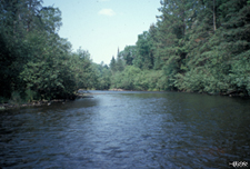
Water quality is affected less in the forested areas of the study unit (Upper Mississippi River and St. Croix River Basins) than in other areas of the Study Unit due to minimal land-cover disturbances. Water quality in the forested areas may affected by minor applications of herbicides at small farms, tree farms, and in lakes (for weed reduction); discharges of waste-water effluent; leaks from septic systems; local stream-channel disturbances from forestry; and localized draining of wetlands. These activities result in small increases in nutrient, pesticide, suspended-sediment, and bacteria concentrations relative to natural conditions. In general, there are few physical modifications to stream channels in forested areas with the exception of some areas that are used are used for commercial forestry practices. Aquatic communities are relatively undisturbed in forested areas due to minimal contaminant sources and minimal physical alterations to surrounding land use.

South Branch

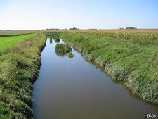
In agricultural areas (most of the Minnesota River Basin and parts of the Mississippi and St. Croix River Basins),water-quality concerns include degradation from point and nonpoint sources of sediment, nutrients, and pesticides, and physical alterations of streams through artificial drainage systems, channel straightening, and removal of riparian vegetation.

Riparian zones are the interface between streams and the surrounding watershed. Wooded riparian vegetation can impede surface runoff and stabilize stream banks thereby reducing the delivery of sediment into streams. Riparian Area
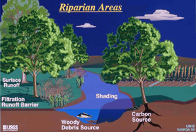
Reduced volumes of sediment delivered to streams may have beneficial effects on aquatic resources by reducing the amount of siltation on fish and invertebrate habitat areas. Reduced sediment in streams increases the visibility for animals that are site predators and increases light penetration that enhances the growth of algae. Perch Wooded riparian vegetation absorbs and reflects solar radiation, resulting in greater thermal stability and decreased light availability for primary production. Wooded riparian vegetation increases habitat complexity by supplying woody debris, which contributes to greater variation in channel and provides habitat for invertebrates, especially in low-gradient streams.

Shingle Creek

Water-quality issues in the urban areas of the study unit include contamination from point and nonpoint sources and physical alterations. Point and nonpoint-source contaminants originate from automobiles, road de-icing chemicals, construction, application of pesticides and fertilizers, atmospheric deposition, street debris in urban stream-water runoff, animal and plant refuse, and discharge from industrial and wastewater treatment facilities.

Mississippi Falls

Physical alterations affecting urban streams include impervious surfaces, drainage of wetlands, construction of detention ponds, loss of riparian cover, stream-channel modifications, and the presence of dams. Impervious surfaces cause greater peak streamflow rates of shorter duration from runoff than would occur naturally, and increase transport of contaminants from streets and parking lots to streams. These factors can increase water temperature and degrade habitat and water quality.

Habitat volume graph

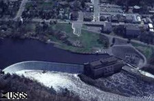
Construction of locks and dams contributes to the loss of floodplain backwater and slough habitats that are important for fish spawning and serve as migration barriers. Hydrologic conditions change due to dam presence and operation. Effects of dams graph 
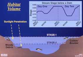
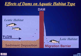
Sediment deposition is greater and stream flow is reduced in areas upstream of dams resulting in more of lentic or lake habitat. Changes in hydrologic conditions may result in shifts in species composition above the dam to those species that prefer lentic habitat rather than stream-like or lotic habitat (greater stream flow). Changes in water levels due to dam operation result in changes in aquatic habitat volume (Mueller, 1993).

Mueller, L., 1993, Winged maple leaf mussel and Higginseye pearly mussel - Freshwater mussels threatened with extinction: Minnesota Department of Agriculture, 19 p.

USGS Home Water Climate Change Core Science Ecosystems Energy and Minerals Env. Health Hazards

Accessibility FOIA Privacy Policies and Notices

USA.gov logo U.S. Department of the Interior | U.S. Geological Survey
URL: http://mn.water.usgs.gov/nawqa/umis/projectDescription/waterQualityEcologicalIssue.html
Page Contact Information: Webmaster
Page Last Modified: Wednesday, 31-Dec-2008 17:34:34 EST

05311000: Flow=985cfs,Stage=5.29ft,Floodstage=14ft,2024-02-26 17:00,>90,MINNESOTA RIVER AT MONTEVIDEO, MN 05301000: Flow=997cfs,Stage=24.10ft,2024-02-26 17:00,>90,MINNESOTA RIVER NEAR LAC QUI PARLE, MN 05292000: Flow=202cfs,Stage=2.64ft,Floodstage=10ft,2024-02-26 17:30,>90,MINNESOTA RIVER AT ORTONVILLE, MN 05129290: Flow=79.6cfs,Stage=14.40ft,Floodstage=20.5ft,2024-02-26 17:30,>90,GOLD PORTAGE OUTLET FROM KABETOGAMA LK NR RAY,MN 05344500: Flow=12800cfs,2024-02-26 16:55,Stage=25.36ft,2024-02-26 17:15:00,76-90,MISSISSIPPI RIVER AT PRESCOTT, WI 05340500: Flow=2800cfs,Stage=3.27ft,2024-02-26 17:00,76-90,ST. CROIX RIVER AT ST. CROIX FALLS, WI 05315000: Flow=50.7cfs,Stage=7.39ft,Floodstage=14ft,2024-02-26 17:00,76-90,REDWOOD RIVER NEAR MARSHALL, MN 05288500: Flow=6750cfs,Stage=3.37ft,Floodstage=12ft,2024-02-26 17:00,76-90,MISSISSIPPI RIVER AT HWY 610 IN BROOKLYN PARK, MN 05270500: Flow=199cfs,Stage=0.97ft,Floodstage=6ft,2024-02-26 17:15,76-90,SAUK RIVER NEAR ST. CLOUD, MN 05267000: Flow=4100cfs,Stage=9.50ft,2024-02-26 17:15,76-90,MISSISSIPPI RIVER NEAR ROYALTON, MN 05457000: Flow=64.2cfs,Stage=2.76ft,Floodstage=10ft,2024-02-26 17:00,25-75,CEDAR RIVER NEAR AUSTIN, MN 05385500: Flow=132cfs,Stage=1.96ft,2024-02-26 17:30,25-75,SOUTH FORK ROOT RIVER NEAR HOUSTON, MN 05385000: Flow=472cfs,Stage=3.16ft,Floodstage=15ft,2024-02-26 17:45,25-75,ROOT RIVER NEAR HOUSTON, MN 05345000: Flow=38.1cfs,Stage=2.32ft,2024-02-26 17:15,25-75,VERMILLION RIVER NEAR EMPIRE, MN 05333500: Flow=1050cfs,Stage=1.07ft,Floodstage=7ft,2024-02-26 17:00,25-75,ST. CROIX RIVER NEAR DANBURY, WI 05247500: Flow=858cfs,Stage=3.76ft,2024-02-26 17:45,25-75,CROW WING RIVER NEAR PILLAGER, MN 05245100: Flow=102cfs,Stage=1.87ft,Floodstage=7ft,2024-02-26 17:15,25-75,LONG PRAIRIE RIVER AT LONG PRAIRIE, MN 05129115: Flow=260cfs,Stage=5.62ft,Floodstage=14ft,2024-02-26 17:30,25-75,VERMILION RIVER NR CRANE LAKE, MN 05127500: Flow=595cfs,Stage=2.97ft,Floodstage=7.5ft,2024-02-26 17:30,25-75,BASSWOOD RIVER NEAR WINTON, MN 05125000: Flow=128cfs,Stage=2.19ft,Floodstage=6.5ft,2024-02-26 17:30,25-75,SOUTH KAWISHIWI RIVER NEAR ELY, MN 05124480: Flow=71.0cfs,Stage=3.13ft,2024-02-26 17:00,25-75,KAWISHIWI RIVER NEAR ELY, MN 05046000: Flow=339cfs,Stage=2.83ft,2024-02-26 17:30,25-75,OTTER TAIL RIVER BL ORWELL D NR FERGUS FALLS, MN 06604000: Stage=13.22ft,Floodstage=16ft,2024-02-26 17:15,Not ranked,Spirit Lake near Orleans, IA 06483290: Stage=7.20ft,2024-02-26 17:15:00,Floodstage=13ft,Not ranked,Ice affected,Rock River below Tom Creek at Rock Rapids, IA 06482610: Stage=1.89ft,2024-02-26 16:45:00,Floodstage=8.5ft,Not ranked,Ice affected,SPLIT ROCK CREEK AT CORSON,SD 05476000: Stage=7.67ft,2024-02-26 17:30:00,Floodstage=12ft,Not ranked,Ice affected,DES MOINES RIVER AT JACKSON, MN 05475350: Stage=10.68ft,Floodstage=19ft,2024-02-26 17:15,Not ranked,Ice,DES MOINES RIVER ABOVE WINDOM, MN 05388250: Stage=6.58ft,2024-02-26 17:00:00,Floodstage=14ft,Not ranked,Ice affected,Upper Iowa River near Dorchester, IA 05387030: Stage=6.61ft,2024-02-26 17:30,Not ranked,CROOKED CREEK AT FREEBURG MN 05386400: Stage=30.94ft,2024-02-26 17:45,Not ranked,MISSISSIPPI RIVER AT BROWNSVILLE, MN 05384350: Stage=8.25ft,Floodstage=21ft,2024-02-26 17:00,Not ranked,ROOT RIVER ABOVE RUSHFORD, MN 05383950: Stage=7.67ft,2024-02-26 17:00:00,Floodstage=19ft,Not ranked,Ice affected,ROOT RIVER NEAR PILOT MOUND, MN 05383075: Flow=318cfs,Stage=2.50ft,Floodstage=7.5ft,2024-02-26 17:00,Not ranked,LA CROSSE RIVER NEAR LA CROSSE, WI 05378500: Stage=5.71ft,2024-02-26 17:45:00,Floodstage=13ft,Not ranked,Ice affected,MISSISSIPPI RIVER AT WINONA, MN 05378490: Stage=5.97ft,Floodstage=655ft,2024-02-26 17:15,Not ranked,MISSISSIPPI RIVER AT LOCK AND DAM 5A NR WINONA, MN 05374000: Stage=5.23ft,Floodstage=18ft,2024-02-26 17:30,Not ranked,ZUMBRO RIVER AT ZUMBRO FALLS, MN 05372995: Stage=2.38ft,2024-02-26 17:15:00,Floodstage=14ft,Not ranked,Ice affected,SOUTH FORK ZUMBRO RIVER AT ROCHESTER, MN 05355250: Stage=2.93ft,2024-02-26 17:15:00,Floodstage=14ft,Not ranked,Seasonal site,MISSISSIPPI RIVER AT RED WING, MN 05355200: Stage=3.39ft,2024-02-26 17:00:00,Not ranked,Ice affected,CANNON RIVER AT WELCH, MN 05355092: Flow=167cfs,Stage=7.33ft,2024-02-26 17:50,Not ranked,CANNON RIVER AT 9TH ST. BRIDGE IN CANNON FALLS, MN 05355080: Stage=11.92ft,2024-02-26 17:15,Not ranked,PRAIRIE CREEK NEAR CANNON FALLS, MN 05355038: Stage=5.25ft,2024-02-26 17:30,Not ranked,CHUB CREEK AT CO. HWY. 47 ABOVE RANDOLPH, MN 05355024: Flow=128cfs,Stage=889.76ft,Floodstage=897ft,2024-02-26 17:30,Not ranked,CANNON RIVER AT NORTHFIELD MN 05354500: Stage=8.94ft,2024-02-26 17:15:00,Not ranked,Seasonal site,CANNON RIVER AT CO. HWY. 29 BELOW FARIBAULT, MN 05353800: Stage=3.77ft,2024-02-26 17:15:00,Not ranked,Ice affected,STRAIGHT RIVER NEAR FARIBAULT, MN 05344490: Flow=3650cfs,Stage=25.36ft,2024-02-26 17:15,Not ranked,ST. CROIX RIVER AT PRESCOTT, WI 05342000: Flow=91.8cfs,Stage=8.18ft,2024-02-26 17:30,Not ranked,KINNICKINNIC RIVER NEAR RIVER FALLS, WI 05341550: Stage=675.67ft,2024-02-26 17:15:00,Floodstage=687.00ft,Not ranked,Ice affected,ST. CROIX RIVER AT STILLWATER, MN 05338500: Stage=3.19ft,2024-02-26 17:15:00,Floodstage=9ft,Not ranked,Ice affected,SNAKE RIVER NEAR PINE CITY, MN 05336700: Stage=4.23ft,2024-02-26 17:00:00,Not ranked,Ice affected,KETTLE RIVER BELOW SANDSTONE, MN 05331580: Flow=9020cfs,Stage=7.18ft,2024-02-26 16:55,Not ranked,MISSISSIPPI RIVER BELOW L&D 2 AT HASTINGS, MN 05331000: Stage=3.36ft,2024-02-26 17:00:00,Floodstage=14ft,Not ranked,Ice affected,MISSISSIPPI RIVER AT ST. PAUL, MN 05330000: Stage=6.49ft,2024-02-26 17:45:00,Floodstage=25ft,Not ranked,Ice affected,MINNESOTA RIVER NEAR JORDAN, MN 05327000: Stage=3.36ft,2024-02-26 17:00:00,Not ranked,Seasonal site,HIGH ISLAND CREEK NEAR HENDERSON, MN 05325000: Stage=4.38ft,2024-02-26 17:30:00,Floodstage=22ft,Not ranked,Ice affected,MINNESOTA RIVER AT MANKATO, MN 05320500: Stage=1.77ft,2024-02-26 17:00:00,Not ranked,Ice affected,LE SUEUR RIVER NEAR RAPIDAN, MN 05320000: Stage=1.87ft,2024-02-26 16:45:00,Not ranked,Ice affected,BLUE EARTH RIVER NEAR RAPIDAN, MN 05319500: Stage=1.25ft,2024-02-26 17:30:00,Not ranked,Ice affected,WATONWAN RIVER NEAR GARDEN CITY, MN 05317200: Stage=2.31ft,2024-02-26 17:15:00,Not ranked,Ice affected,LITTLE COTTONWOOD RIVER NEAR COURTLAND, MN 05317000: Stage=4.30ft,2024-02-26 17:00:00,Floodstage=11ft,Not ranked,Ice affected,COTTONWOOD RIVER NEAR NEW ULM, MN 05316770: Stage=787.64ft,2024-02-26 17:45:00,Floodstage=800ft,Not ranked,Ice affected,MINNESOTA RIVER AT NEW ULM, MN 05316580: Flow=1470cfs,Stage=10.86ft,Floodstage=21ft,2024-02-26 17:00,Not ranked,MINNESOTA RIVER AT MORTON, MN 05316500: Stage=2.35ft,2024-02-26 17:00:00,Floodstage=6ft,Not ranked,Ice affected,REDWOOD RIVER NEAR REDWOOD FALLS, MN 05313500: Stage=3.39ft,2024-02-26 17:45:00,Not ranked,Ice affected,YELLOW MEDICINE RIVER NEAR GRANITE FALLS, MN 05311150: Flow=634cfs,2023-11-15 05:45,Stage=881.02ft,2024-02-26 17:15:00,Floodstage=885ft,Not ranked,MINNESOTA RIVER AT HWY 212 IN GRANITE FALLS, MN 05305000: Stage=36.11ft,2024-02-26 17:00:00,Not ranked,Ice affected,CHIPPEWA RIVER (TW) NEAR WATSON, MN 05304995: Stage=39.57ft,2024-02-26 17:00,Not ranked,CHIPPEWA R. (HW) ABOVE COUNTY RD 13 NR WATSON, MN 05304500: Stage=1.64ft,2024-02-26 17:45:00,Not ranked,Ice affected,CHIPPEWA RIVER NEAR MILAN, MN 05300000: Stage=7.06ft,2024-02-26 17:45:00,Not ranked,Ice affected,LAC QUI PARLE RIVER NEAR LAC QUI PARLE, MN 05294000: Stage=5.18ft,2024-02-26 17:00:00,Not ranked,Ice affected,POMME DE TERRE RIVER AT APPLETON, MN 05293000: Stage=2.98ft,2024-02-26 17:15:00,Not ranked,Ice affected,YELLOW BANK RIVER NEAR ODESSA, MN 05291000: Stage=1.84ft,2024-02-26 17:45:00,Floodstage=12ft,Not ranked,Ice affected,WHETSTONE RIVER NEAR BIG STONE CITY, SD 05290000: Stage=10.92ft,2024-02-26 17:00:00,Floodstage=17ft,Not ranked,Ice affected,LITTLE MINNESOTA RIVER NEAR PEEVER, SD 05289800: Stage=12.03ft,2024-02-26 17:00:00,Not ranked,Ice affected,MINNEHAHA CREEK AT HIAWATHA AVE. IN MINNEAPOLIS,MN 05289100: Stage=925.22ft,2024-02-26 17:00,Not ranked,MINNEHAHA CREEK BLW GRAYS BAY DAM IN MINNETONKA MN 05289000: Stage=928.73ft,2024-02-26 17:00,Not ranked,LAKE MINNETONKA ABV GRAYS BAY OTLT IN MINNETONKA 05288705: Stage=9.16ft,2024-02-26 17:00:00,Not ranked,Ice affected,SHINGLE CREEK AT QUEEN AVE IN MINNEAPOLIS, MN 05288670: Stage=89.44ft,Floodstage=16ft,2024-02-26 17:30,Not ranked,MISSISSIPPI RIVER ABV 37TH AVE. NE IN FRIDLEY, MN 05288580: Stage=6.29ft,2024-02-26 17:00:00,Not ranked,Ice affected,RICE CREEK BLW OLD HWY. 8 IN MOUNDS VIEW, MN 05287890: Stage=3.95ft,2024-02-26 17:00:00,Not ranked,Ice affected,ELM CREEK NR CHAMPLIN, MN 05286000: Stage=2.83ft,2024-02-26 17:00:00,Floodstage=8ft,Not ranked,Ice affected,RUM RIVER NEAR ST. FRANCIS, MN 05284000: Stage=10.75ft,2024-02-26 17:15,Not ranked,MILLE LACS LAKE AT COVE BAY NEAR ONAMIA, MN 05283500: Stage=4.55ft,2024-02-26 17:30:00,Floodstage=12ft,Not ranked,Ice affected,MISSISSIPPI RIVER AT US HWY 169 AT CHAMPLIN, MN 05280000: Stage=3.25ft,2024-02-26 17:00:00,Floodstage=10ft,Not ranked,Ice affected,CROW RIVER AT ROCKFORD, MN 05275000: Stage=1.01ft,2024-02-26 17:15:00,Not ranked,Ice affected,ELK RIVER NEAR BIG LAKE, MN 05270700: Stage=4.80ft,2024-02-26 16:45:00,Floodstage=9ft,Not ranked,Ice affected,MISSISSIPPI RIVER AT ST. CLOUD, MN 05244000: Stage=2.69ft,2024-02-26 17:00:00,Not ranked,Ice affected,CROW WING RIVER AT NIMROD, MN 05243725: Stage=1.16ft,2024-02-26 17:30:00,Not ranked,Ice affected,STRAIGHT RIVER NEAR PARK RAPIDS, MN 05242300: Stage=5.97ft,2024-02-26 17:30:00,Floodstage=16ft,Not ranked,Back Water,MISSISSIPPI RIVER AT BRAINERD, MN 05227530: Not ranked,Equipment malfunction,MISSISSIPPI RIVER DIVERSION NEAR AITKIN, MN 05227500: Stage=6.44ft,2024-02-26 17:30:00,Floodstage=13ft,Not ranked,Back Water,MISSISSIPPI RIVER AT AITKIN, MN 05212700: Stage=2.57ft,2024-02-26 17:45:00,Floodstage=10ft,Not ranked,Ice affected,PRAIRIE RIVER NEAR TACONITE, MN 05211000: Stage=2.76ft,2024-02-26 17:15:00,Not ranked,Ice affected,MISSISSIPPI RIVER AT GRAND RAPIDS, MN 05210000: Stage=72.44ft,2024-02-26 17:30,Not ranked,MISSISSIPPI R. AT DAYS HIGH LANDING NR DEER RIVER 05207600: Stage=5.48ft,2024-02-26 17:15:00,Not ranked,Ice affected,MISSISSIPPI RIVER AT WILLOW BEACH AT BALL CLUB, MN 05205900: Stage=94.47ft,2024-02-26 17:30,Not ranked,LEECH LAKE AT SUGAR POINT NEAR FEDERAL DAM, MN 05200510: Not ranked,Seasonal site,MISSISSIPPI RIVER NEAR BEMIDJI, MN 05140521: Stage=58.25ft,2024-02-26 17:00,Not ranked,LK OF THE WOODS @ SPRINGSTEEL IS NR. WARROAD, MN 05140520: Stage=58.27ft,2024-02-26 17:30,Not ranked,LAKE OF THE WOODS AT WARROAD, MN 05137500: Stage=4.00ft,2024-02-26 17:00,Not ranked,RAINY RIVER NEAR BOAT LANDING AT WHEELERS POINT,MN 05134200: Not ranked,Equipment malfunction,RAPID RIVER NEAR BAUDETTE, MN 05133500: Stage=3.39ft,2024-02-26 17:30:00,Not ranked,Ice affected,RAINY RIVER AT MANITOU RAPIDS, MN 05132000: Stage=3.76ft,2024-02-26 17:30:00,Floodstage=16ft,Not ranked,Ice affected,BIG FORK RIVER AT BIG FALLS, MN 05131500: Stage=2.89ft,2024-02-26 17:30:00,Floodstage=22ft,Not ranked,Ice affected,LITTLE FORK RIVER AT LITTLEFORK, MN 05129515: Stage=15.12ft,2024-02-26 17:30:00,Not ranked,Ice affected,RAINY R AT BOAT LANDING BLW INTERNATIONAL FALLS,MN 05126210: Flow=259cfs,Stage=3.95ft,2024-02-26 17:30,Not ranked,SOUTH KAWISHIWI R ABV WHITE IRON LAKE NR ELY, MN 05112000: Stage=2.35ft,2024-02-26 17:30:00,Not ranked,Ice affected,ROSEAU RIVER BELOW STATE DITCH 51 NR CARIBOU, MN 05107500: Stage=2.32ft,2024-02-26 17:30:00,Not ranked,Ice affected,ROSEAU RIVER AT ROSS, MN 05106000: Not ranked,Equipment malfunction,SPRAGUE CREEK NEAR SPRAGUE, MANITOBA, CANADA 05104500: Stage=3.96ft,2024-02-26 17:00:00,Not ranked,Ice affected,ROSEAU RIVER BELOW SOUTH FORK NEAR MALUNG, MN 05102490: Stage=14.44ft,Floodstage=39ft,2024-02-26 17:30,Not ranked,RED RIVER OF THE NORTH AT PEMBINA, ND 05094000: Stage=3.40ft,2024-02-26 17:15:00,Not ranked,Ice affected,SOUTH BRANCH TWO RIVERS AT LAKE BRONSON, MN 05092000: Stage=12.91ft,2024-02-26 17:45:00,Floodstage=32ft,Not ranked,Ice affected,RED RIVER OF THE NORTH AT DRAYTON, ND 05087500: Stage=3.91ft,2024-02-26 14:00:00,Not ranked,Ice affected,MIDDLE RIVER AT ARGYLE, MN 05085450: Stage=61.87ft,2024-02-26 16:45:00,Floodstage=67ft,Not ranked,Ice affected,SNAKE RIVER ABOVE WARREN, MN 05083500: Stage=10.09ft,Floodstage=26ft,2024-02-26 17:15,Not ranked,RED RIVER OF THE NORTH AT OSLO, MN 05082500: Stage=16.58ft,2024-02-26 17:45:00,Floodstage=28ft,Not ranked,Ice affected,RED RIVER OF THE NORTH AT GRAND FORKS, ND 05080000: Stage=12.48ft,2024-02-26 17:30:00,Not ranked,Ice affected,RED LAKE RIVER AT FISHER, MN 05079000: Stage=5.02ft,2024-02-26 16:15:00,Floodstage=15ft,Not ranked,Ice affected,RED LAKE RIVER AT CROOKSTON, MN 05078500: Not ranked,Equipment malfunction,CLEARWATER RIVER AT RED LAKE FALLS, MN 05078230: Stage=3.78ft,2024-02-26 17:30:00,Not ranked,Ice affected,LOST RIVER AT OKLEE, MN 05078000: Stage=3.42ft,2024-02-26 17:15:00,Not ranked,Ice affected,CLEARWATER RIVER AT PLUMMER, MN 05076000: Stage=4.69ft,2024-02-26 17:15:00,Not ranked,Ice affected,THIEF RIVER NEAR THIEF RIVER FALLS, MN 05075000: Stage=5.30ft,2024-02-26 17:00:00,Floodstage=12ft,Not ranked,Seasonal site,RED LAKE RIVER AT HIGH LANDING NR GOODRIDGE, MN 05074500: Stage=69.65ft,2024-02-26 17:30:00,Not ranked,Ice affected,RED LAKE RIVER NEAR RED LAKE, MN 05074000: Stage=74.19ft,2024-02-26 17:30,Not ranked,LOWER RED LAKE NR RED LAKE, MN 05073500: Stage=74.07ft,2024-02-26 17:30,Not ranked,UPPER RED LAKE AT WASKISH, MN 05070000: Stage=19.32ft,2024-02-26 17:15:00,Not ranked,Ice affected,RED RIVER OF THE NORTH NEAR THOMPSON, ND 05069000: Stage=5.19ft,2024-02-26 17:45:00,Floodstage=20ft,Not ranked,Ice affected,SAND HILL RIVER AT CLIMAX, MN 05067500: Flow=0.09cfs,2023-11-30 19:45,Not ranked,MARSH RIVER NEAR SHELLY, MN 05064500: Stage=8.32ft,2024-02-26 17:30:00,Floodstage=26ft,Not ranked,Ice affected,RED RIVER OF THE NORTH AT HALSTAD, MN 05064000: Stage=5.71ft,2024-02-26 17:30:00,Floodstage=20ft,Not ranked,Ice affected,WILD RICE RIVER AT HENDRUM, MN 05063398: Stage=5.75ft,2024-02-26 17:00:00,Not ranked,Back Water,S. BR. WILD RICE RIVER AT CO. RD. 27 NR FELTON, MN 05062500: Stage=2.60ft,2024-02-26 16:45:00,Floodstage=10ft,Not ranked,Ice affected,WILD RICE RIVER AT TWIN VALLEY, MN 05062000: Not ranked,Equipment malfunction,BUFFALO RIVER NEAR DILWORTH, MN 05061500: Stage=7.00ft,2024-02-26 17:45:00,Floodstage=13ft,Not ranked,Back Water,SOUTH BRANCH BUFFALO RIVER AT SABIN, MN 05061000: Stage=3.30ft,2024-02-26 16:45:00,Floodstage=8ft,Not ranked,Ice affected,BUFFALO RIVER NEAR HAWLEY, MN 05060400: Stage=69.50ft,2024-02-26 17:15:00,Floodstage=84ft,Not ranked,Ice affected,SHEYENNE RIVER AT HARWOOD, ND 05054000: Stage=15.05ft,2024-02-26 17:15:00,Floodstage=18ft,Not ranked,Ice affected,RED RIVER OF THE NORTH AT FARGO, ND 05053000: Stage=11.08ft,2024-02-26 14:00:00,Floodstage=20ft,Not ranked,Ice affected,WILD RICE RIVER NR ABERCROMBIE, ND 05052500: Stage=24.01ft,2023-10-01 00:45:00,Not ranked,Zero flow,ANTELOPE CREEK AT DWIGHT, ND 05051522: Stage=11.68ft,2024-02-26 16:45:00,Floodstage=30ft,Not ranked,Ice affected,RED RIVER OF THE NORTH AT HICKSON, ND 05051500: Stage=5.16ft,2024-02-26 17:30:00,Floodstage=11ft,Not ranked,Ice affected,RED RIVER OF THE NORTH AT WAHPETON, ND 05051300: Stage=7.95ft,2024-02-26 17:00:00,Not ranked,Ice affected,BOIS DE SIOUX RIVER NEAR DORAN, MN 05050000: Stage=5.17ft,2024-02-26 17:30:00,Floodstage=14ft,Not ranked,Ice affected,BOIS DE SIOUX RIVER NEAR WHITE ROCK, SD 05049995: Stage=72.42ft,2024-02-26 17:30,Not ranked,MUD LAKE ABOVE WHITE ROCK DAM NEAR WHITE ROCK, SD 05049710: Stage=72.65ft,2024-02-26 17:00,Not ranked,LAKE TRAVERSE OTLT AT RESERVATION DAM NR WHEATON 05049700: Stage=77.03ft,2024-02-26 17:00,Not ranked,LAKE TRAVERSE AT RESERVATION DAM NEAR WHEATON, MN 05049000: Stage=77.05ft,2024-02-26 17:30:00,Not ranked,Seasonal site,MUSTINKA RIVER ABOVE WHEATON, MN 05046475: Stage=15.06ft,2024-01-07 00:45:00,Not ranked,Ice affected,OTTER TAIL RIVER DIVERSION AT BRECKENRIDGE, MN 05030500: Flow=334cfs,Stage=5.66ft,2024-02-26 17:00,Not ranked,OTTER TAIL RIVER NEAR ELIZABETH, MN 04024430: Stage=4.89ft,2024-02-26 17:00:00,Floodstage=24ft,Not ranked,Back Water,NEMADJI RIVER NEAR SOUTH SUPERIOR, WI 04024000: Stage=3.81ft,2024-02-26 17:30:00,Floodstage=10.5ft,Not ranked,Ice affected,ST. LOUIS RIVER AT SCANLON, MN 04021520: Stage=3.94ft,2024-02-26 17:00:00,Not ranked,Back Water,STONEY BROOK AT PINE DRIVE NEAR BROOKSTON, MN 04015438: Stage=17.60ft,2024-02-26 16:45:00,Not ranked,Ice affected,ST. LOUIS RIVER NEAR SKIBO, MN 04015330: Not ranked,Equipment malfunction,KNIFE RIVER NEAR TWO HARBORS, MN 04010500: Not ranked,Equipment malfunction,PIGEON RIVER AT MIDDLE FALLS NR GRAND PORTAGE MN Go to WaterWatch (offsite) for a larger map with additional options