Minnesota DroughtWatch
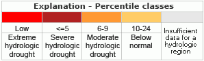
Minnesota DroughtWatchThis map (from USGS's National Drought Watch Web site) shows the 7-day average streamflow conditions in hydrologic units. Thus, the map shows conditions adjusted for this time of the year. The colors represent 7-day average streamflow percentiles for the day of the year. USGS sites having at least 30 years of record are used. The data used to produce this map are provisional and have not been reviewed or edited. They may be subject to significant change. Minnesota DroughtWatch MapsAverage streamflow maps:
Minnesota WaterWatch - DroughtDrought Analyses
Drought Management
Drought Links of Other Agencies
Map of below normal 7-day average streamflow compared to historical streamflow for the day of year
Drip CalculatorCheck your faucets at home -- do any of them drip? Enough unchecked drips in enough houses can add up to a flood of wasted water—a disturbing fact in those parts of the country in drought conditions. Use our handy drip calculator to see how many gallons of water can go down the drain if your drippy faucets keep dripping. |
![]() U.S. Department of the Interior |
U.S. Geological Survey
U.S. Department of the Interior |
U.S. Geological Survey
URL: http://mn.water.usgs.gov/drought/index.html
Page Contact Information: Webmaster
Page Last Modified: Friday, 05-Oct-2012 11:31:56 EDT