USGS - science for a changing world

Minnesota Water Science Center

  Home   Information/Data   Projects   Publications   Flood   NAWQA   Office   Contact   Other USGS [an error occurred while processing this directive]   Internal
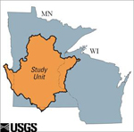
UMIS Study Unit Map.

UMIS NAWQA

USGS IN YOUR STATE

USGS Water Science Centers are located in each state.

There is a USGS Water Science Center office in each State. Washington Oregon California Idaho Nevada Montana Wyoming Utah Colorado Arizona New Mexico North Dakota South Dakota Nebraska Kansas Oklahoma Texas Minnesota Iowa Missouri Arkansas Louisiana Wisconsin Illinois Mississippi Michigan Indiana Ohio Kentucky Tennessee Alabama Pennsylvania West Virginia Georgia Florida Caribbean Alaska Hawaii New York Vermont New Hampshire Maine Massachusetts South Carolina North Carolina Rhode Island Virginia Connecticut New Jersey Maryland-Delaware-D.C.
Snowmelt Study Site Characteristics
Site
identifier
Site name Latitude Longitude County Glacial deposit
composition
or dominant
physiographic
source
Surficial
geology
Land Use
Drainage
area
(sq.mi.)
05267000
05268000
05270500
05275000
05276005
05278400
05278590
05278930
05280000
05286000
05288500
05288705
05320270
05330000
05330902
05331580
05331775
05331833
05333400
05333500
053350006
05335170
05335500
05336700
05338500
05338975
453049-092512101
05340370
05340500
053405524
05341125
05341500
05341540
05341740
05342000
05344490
05345000
05353800
05355200
05355250
05355330

Mississippi River near Royalton, Minn.
Platte River at Royalton, Minn.
Sauk River near St. Cloud, Minn.
Elk River near Big Lake, Minn.
North Fork Crow River above Paynesville, Minn.
North Fork Crow River near Rockford, Minn.
South Fork Crow River at Biscay, Minn.
Buffalo Creek near Glencoe, Minn.
Crow River at Rockford, Minn.
Rum River near St. Francis, Minn.
Mississippi River near Anoka, Minn.
Shingle Creek at Queen Ave in Minneapolis, Minn.
Little Cobb River near Beauford, Minn.
Minnesota River near Jordan, Minn.
Nine Mile Creek near James Circle at Bloomington, Minn.
Mississippi River below Lock & Dam #2 at Hastings, Minn.
St. Croix River near Woodland Corner, Wisc.
Namekagon River at Leonards, Wisc.
Namekagon River near Woodland Corner, Wisc.
St. Croix River near Danbury, Wisc.
Yellow River near Danbury, Wisc.
Crooked Creek near Hinckley, Minn.
Clam River near Webster, Wisc.
Kettle River below Sandstone, Minn.
Snake River near Pine City, Minn.
Wood River at State Highway 70 near Grantsburg, Wisc.

Sunrise River at Sunrise, Minn.
Trade River near Trade River, Wisc.
St. Croix River at St. Croix Falls, Wisc.
St. Croix River tributary near Osceola, Wisc.
Apple River near Range, Wisc.
Apple River near Somerset, Wisc.
Browns Creek at Stillwater, Minn.
Willow River at Burkhardt, Wisc.
Kinnickinnic River near River Falls, Wisc.
St. Croix River at Prescott, Wisc.
Vermillion River near Empire, Minn.
Straight River near Faribault, Minn.
Cannon River at Welch, Minn.
Mississippi River at Red Wing, Minn.
Rush River near Maiden Rock, Wisc.

455140
455043
453335
452002
452238
450544
445011
444550
450512
451940
450736
450300
435948
444135
444826
444448
460700
461018
460502
460428
455859
460042
455252
460620
455030
454622

453049
453558
452425
452052
452345
450927
450435
450130
444950
444457
444000
441529
443350
443636
443415

942130
941740
941400
934000
944700
934718
941716
940527
934402
932220
931748
931836
935430
933830
931805
925108
920753
911950
920647
921450
922305
923145
922916
925150
925600
924229

925121
924602
923849
924055
922150
924259
924821
923923
924400
924816
930317
931351
924355
923636
921944
Morrison
Morrison
Stearns
Sherburne
Kandiyohi
Wright
McLeod
McLeod
Wright
Anoka
Hennepin
Hennepin
Blue Earth
Scott
Hennepin
Dakota
Burnett
Bayfield
Burnett
Burnett
Burnett
Pine
Burnett
Pine
Pine
Burnett

Chisago
Polk
Polk
Polk
Polk
St. Croix
Washington
St. Croix
Pierce
Pierce
Dakota
Rice
Goodhue
Goodhue
Pierce
Outwash-Alluvium
Outwash-Alluvium
Outwash-Alluvium
Outwash-Alluvium
Outwash-Alluvium
Till plain-Moraine
Till plain-Moraine
Till plain-Moraine
Till plain-Moraine
Outwash-Alluvium
Outwash-Alluvium
Outwash-Alluvium
Till plain-Moraine
Till plain-Moraine
Till plain-Moraine
Till plain-Moraine
Outwash-Alluvium
Outwash-Alluvium
Outwash-Alluvium
Outwash-Alluvium
Outwash-Alluvium
Outwash-Alluvium
Outwash-Alluvium
Outwash-Alluvium
Till plain-Moraine
Outwash-Alluvium

Outwash-Alluvium
Outwash-Alluvium
Till plain-Moraine
Till plain-Moraine
Outwash-Alluvium
Till plain-Moraine
Till plain-Moraine
Outwash-Alluvium
Driftless
Till plain-Moraine
Outwash-Alluvium
Till plain-Moraine
Till plain-Moraine
Till plain-Moraine
Driftless
Calcareous
Calcareous
Calcareous
Calcareous
Calcareous
Calcareous
Calcareous
Calcareous
Calcareous
Calcareous
Calcareous
Calcareous
Calcareous
Calcareous
Calcareous
Calcareous
Siliceous
Siliceous
Siliceous
Siliceous
Siliceous
Siliceous
Siliceous
Siliceous
Calcareous
Siliceous

Calcareous
Siliceous
Siliceous
Siliceous
Siliceous
Siliceous
Calcareous
Siliceous
Calcareous
Siliceous
Calcareous
Calcareous
Calcareous
Calcareous
Calcareous
0.6
0.4
1.1
0.8
0.3
1.2
2.3
0.7
1.4
0.5
1.1
71
0.2
0.9
87
2.5
0.2
0.7
0.4
0.3
0.8
0
0.3
0.5
0.4
0.6

2.9
0.5
0.4
4.4
0
0.5
6.7
1.1
3.6
0.9
16
3.5
2.8
2.3
0.5
25
64
83
75
90
83
89
96
87
47
45
20
94
94
5.7
66
1
1.8
6
4.9
23
18
32
27
40
44

58
47
26
65
44
63
80
89
92
36.7
76
92
88
62
88

49
23
8.4
10
2.1
6.3
0.6
0
3.7
22
34
0.9
0.5
1.7
2.2
18
86
78
76
79
56
69
55
53
42
27

8.3
38
56
29
40
24
5.8
7.8
4.6
46.8
3.9
1.5
4
22
11
8.6
1.9
4.3
1.3
1.7
6
6
1.7
4.8
16
7.6
4
0.6
2.2
3.7
5.2
3.4
6.3
4.4
4
9
1.4
3.1
1.7
1.2
5

5.3
2.6
2.8
0.4
5.5
5.1
4.3
0.6
0.2
3.2
1.7
0.8
2.7
4.8
0.1
.16
10
2.7
13
5.6
3.5
2.2
0.9
2.7
14
12
0.7
4
1.1
1.7
7.1
9.6
12
13
12
11
12
9.9
18
16
24

26
12
14
0
10
7.1
2.9
1.1
0
12.2
0.5
2.1
2
7.8
0
11600
424
1030
549
232
1350
477
373
2640
1380
19200
28.2
130
16200
44.6
37000
433
128
1020
1510
312
94.4
358
868
975
160

170
133
6149
10
167
551
34.1
254
173
7691.5
129
436
1340
46800
225

USGS Home Water Climate Change Core Science Ecosystems Energy and Minerals Env. Health Hazards

Accessibility FOIA Privacy Policies and Notices

USA.gov logo U.S. Department of the Interior | U.S. Geological Survey
URL: http://mn.water.usgs.gov/nawqa/umis/projectDescription/snowmeltStudySiteCharacteristics.html
Page Contact Information: Webmaster
Page Last Modified: Wednesday, 31-Dec-2008 17:34:29 EST

05311000: Flow=985cfs,Stage=5.29ft,Floodstage=14ft,2024-02-26 17:00,>90,MINNESOTA RIVER AT MONTEVIDEO, MN 05301000: Flow=997cfs,Stage=24.10ft,2024-02-26 17:00,>90,MINNESOTA RIVER NEAR LAC QUI PARLE, MN 05292000: Flow=202cfs,Stage=2.64ft,Floodstage=10ft,2024-02-26 17:30,>90,MINNESOTA RIVER AT ORTONVILLE, MN 05129290: Flow=79.6cfs,Stage=14.40ft,Floodstage=20.5ft,2024-02-26 17:30,>90,GOLD PORTAGE OUTLET FROM KABETOGAMA LK NR RAY,MN 05344500: Flow=12800cfs,2024-02-26 16:55,Stage=25.36ft,2024-02-26 17:15:00,76-90,MISSISSIPPI RIVER AT PRESCOTT, WI 05340500: Flow=2800cfs,Stage=3.27ft,2024-02-26 17:00,76-90,ST. CROIX RIVER AT ST. CROIX FALLS, WI 05315000: Flow=50.7cfs,Stage=7.39ft,Floodstage=14ft,2024-02-26 17:00,76-90,REDWOOD RIVER NEAR MARSHALL, MN 05288500: Flow=6750cfs,Stage=3.37ft,Floodstage=12ft,2024-02-26 17:00,76-90,MISSISSIPPI RIVER AT HWY 610 IN BROOKLYN PARK, MN 05270500: Flow=199cfs,Stage=0.97ft,Floodstage=6ft,2024-02-26 17:15,76-90,SAUK RIVER NEAR ST. CLOUD, MN 05267000: Flow=4100cfs,Stage=9.50ft,2024-02-26 17:15,76-90,MISSISSIPPI RIVER NEAR ROYALTON, MN 05457000: Flow=64.2cfs,Stage=2.76ft,Floodstage=10ft,2024-02-26 17:00,25-75,CEDAR RIVER NEAR AUSTIN, MN 05385500: Flow=132cfs,Stage=1.96ft,2024-02-26 17:30,25-75,SOUTH FORK ROOT RIVER NEAR HOUSTON, MN 05385000: Flow=472cfs,Stage=3.16ft,Floodstage=15ft,2024-02-26 17:45,25-75,ROOT RIVER NEAR HOUSTON, MN 05345000: Flow=38.1cfs,Stage=2.32ft,2024-02-26 17:15,25-75,VERMILLION RIVER NEAR EMPIRE, MN 05333500: Flow=1050cfs,Stage=1.07ft,Floodstage=7ft,2024-02-26 17:00,25-75,ST. CROIX RIVER NEAR DANBURY, WI 05247500: Flow=858cfs,Stage=3.76ft,2024-02-26 17:45,25-75,CROW WING RIVER NEAR PILLAGER, MN 05245100: Flow=102cfs,Stage=1.87ft,Floodstage=7ft,2024-02-26 17:15,25-75,LONG PRAIRIE RIVER AT LONG PRAIRIE, MN 05129115: Flow=260cfs,Stage=5.62ft,Floodstage=14ft,2024-02-26 17:30,25-75,VERMILION RIVER NR CRANE LAKE, MN 05127500: Flow=595cfs,Stage=2.97ft,Floodstage=7.5ft,2024-02-26 17:30,25-75,BASSWOOD RIVER NEAR WINTON, MN 05125000: Flow=128cfs,Stage=2.19ft,Floodstage=6.5ft,2024-02-26 17:30,25-75,SOUTH KAWISHIWI RIVER NEAR ELY, MN 05124480: Flow=71.0cfs,Stage=3.13ft,2024-02-26 17:00,25-75,KAWISHIWI RIVER NEAR ELY, MN 05046000: Flow=339cfs,Stage=2.83ft,2024-02-26 17:30,25-75,OTTER TAIL RIVER BL ORWELL D NR FERGUS FALLS, MN 06604000: Stage=13.22ft,Floodstage=16ft,2024-02-26 17:15,Not ranked,Spirit Lake near Orleans, IA 06483290: Stage=7.20ft,2024-02-26 17:15:00,Floodstage=13ft,Not ranked,Ice affected,Rock River below Tom Creek at Rock Rapids, IA 06482610: Stage=1.89ft,2024-02-26 16:45:00,Floodstage=8.5ft,Not ranked,Ice affected,SPLIT ROCK CREEK AT CORSON,SD 05476000: Stage=7.67ft,2024-02-26 17:30:00,Floodstage=12ft,Not ranked,Ice affected,DES MOINES RIVER AT JACKSON, MN 05475350: Stage=10.68ft,Floodstage=19ft,2024-02-26 17:15,Not ranked,Ice,DES MOINES RIVER ABOVE WINDOM, MN 05388250: Stage=6.58ft,2024-02-26 17:00:00,Floodstage=14ft,Not ranked,Ice affected,Upper Iowa River near Dorchester, IA 05387030: Stage=6.61ft,2024-02-26 17:30,Not ranked,CROOKED CREEK AT FREEBURG MN 05386400: Stage=30.94ft,2024-02-26 17:45,Not ranked,MISSISSIPPI RIVER AT BROWNSVILLE, MN 05384350: Stage=8.25ft,Floodstage=21ft,2024-02-26 17:00,Not ranked,ROOT RIVER ABOVE RUSHFORD, MN 05383950: Stage=7.67ft,2024-02-26 17:00:00,Floodstage=19ft,Not ranked,Ice affected,ROOT RIVER NEAR PILOT MOUND, MN 05383075: Flow=318cfs,Stage=2.50ft,Floodstage=7.5ft,2024-02-26 17:00,Not ranked,LA CROSSE RIVER NEAR LA CROSSE, WI 05378500: Stage=5.71ft,2024-02-26 17:45:00,Floodstage=13ft,Not ranked,Ice affected,MISSISSIPPI RIVER AT WINONA, MN 05378490: Stage=5.97ft,Floodstage=655ft,2024-02-26 17:15,Not ranked,MISSISSIPPI RIVER AT LOCK AND DAM 5A NR WINONA, MN 05374000: Stage=5.23ft,Floodstage=18ft,2024-02-26 17:30,Not ranked,ZUMBRO RIVER AT ZUMBRO FALLS, MN 05372995: Stage=2.38ft,2024-02-26 17:15:00,Floodstage=14ft,Not ranked,Ice affected,SOUTH FORK ZUMBRO RIVER AT ROCHESTER, MN 05355250: Stage=2.93ft,2024-02-26 17:15:00,Floodstage=14ft,Not ranked,Seasonal site,MISSISSIPPI RIVER AT RED WING, MN 05355200: Stage=3.39ft,2024-02-26 17:00:00,Not ranked,Ice affected,CANNON RIVER AT WELCH, MN 05355092: Flow=167cfs,Stage=7.33ft,2024-02-26 17:50,Not ranked,CANNON RIVER AT 9TH ST. BRIDGE IN CANNON FALLS, MN 05355080: Stage=11.92ft,2024-02-26 17:15,Not ranked,PRAIRIE CREEK NEAR CANNON FALLS, MN 05355038: Stage=5.25ft,2024-02-26 17:30,Not ranked,CHUB CREEK AT CO. HWY. 47 ABOVE RANDOLPH, MN 05355024: Flow=128cfs,Stage=889.76ft,Floodstage=897ft,2024-02-26 17:30,Not ranked,CANNON RIVER AT NORTHFIELD MN 05354500: Stage=8.94ft,2024-02-26 17:15:00,Not ranked,Seasonal site,CANNON RIVER AT CO. HWY. 29 BELOW FARIBAULT, MN 05353800: Stage=3.77ft,2024-02-26 17:15:00,Not ranked,Ice affected,STRAIGHT RIVER NEAR FARIBAULT, MN 05344490: Flow=3650cfs,Stage=25.36ft,2024-02-26 17:15,Not ranked,ST. CROIX RIVER AT PRESCOTT, WI 05342000: Flow=91.8cfs,Stage=8.18ft,2024-02-26 17:30,Not ranked,KINNICKINNIC RIVER NEAR RIVER FALLS, WI 05341550: Stage=675.67ft,2024-02-26 17:15:00,Floodstage=687.00ft,Not ranked,Ice affected,ST. CROIX RIVER AT STILLWATER, MN 05338500: Stage=3.19ft,2024-02-26 17:15:00,Floodstage=9ft,Not ranked,Ice affected,SNAKE RIVER NEAR PINE CITY, MN 05336700: Stage=4.23ft,2024-02-26 17:00:00,Not ranked,Ice affected,KETTLE RIVER BELOW SANDSTONE, MN 05331580: Flow=9020cfs,Stage=7.18ft,2024-02-26 16:55,Not ranked,MISSISSIPPI RIVER BELOW L&D 2 AT HASTINGS, MN 05331000: Stage=3.36ft,2024-02-26 17:00:00,Floodstage=14ft,Not ranked,Ice affected,MISSISSIPPI RIVER AT ST. PAUL, MN 05330000: Stage=6.49ft,2024-02-26 17:45:00,Floodstage=25ft,Not ranked,Ice affected,MINNESOTA RIVER NEAR JORDAN, MN 05327000: Stage=3.36ft,2024-02-26 17:00:00,Not ranked,Seasonal site,HIGH ISLAND CREEK NEAR HENDERSON, MN 05325000: Stage=4.38ft,2024-02-26 17:30:00,Floodstage=22ft,Not ranked,Ice affected,MINNESOTA RIVER AT MANKATO, MN 05320500: Stage=1.77ft,2024-02-26 17:00:00,Not ranked,Ice affected,LE SUEUR RIVER NEAR RAPIDAN, MN 05320000: Stage=1.87ft,2024-02-26 16:45:00,Not ranked,Ice affected,BLUE EARTH RIVER NEAR RAPIDAN, MN 05319500: Stage=1.25ft,2024-02-26 17:30:00,Not ranked,Ice affected,WATONWAN RIVER NEAR GARDEN CITY, MN 05317200: Stage=2.31ft,2024-02-26 17:15:00,Not ranked,Ice affected,LITTLE COTTONWOOD RIVER NEAR COURTLAND, MN 05317000: Stage=4.30ft,2024-02-26 17:00:00,Floodstage=11ft,Not ranked,Ice affected,COTTONWOOD RIVER NEAR NEW ULM, MN 05316770: Stage=787.64ft,2024-02-26 17:45:00,Floodstage=800ft,Not ranked,Ice affected,MINNESOTA RIVER AT NEW ULM, MN 05316580: Flow=1470cfs,Stage=10.86ft,Floodstage=21ft,2024-02-26 17:00,Not ranked,MINNESOTA RIVER AT MORTON, MN 05316500: Stage=2.35ft,2024-02-26 17:00:00,Floodstage=6ft,Not ranked,Ice affected,REDWOOD RIVER NEAR REDWOOD FALLS, MN 05313500: Stage=3.39ft,2024-02-26 17:45:00,Not ranked,Ice affected,YELLOW MEDICINE RIVER NEAR GRANITE FALLS, MN 05311150: Flow=634cfs,2023-11-15 05:45,Stage=881.02ft,2024-02-26 17:15:00,Floodstage=885ft,Not ranked,MINNESOTA RIVER AT HWY 212 IN GRANITE FALLS, MN 05305000: Stage=36.11ft,2024-02-26 17:00:00,Not ranked,Ice affected,CHIPPEWA RIVER (TW) NEAR WATSON, MN 05304995: Stage=39.57ft,2024-02-26 17:00,Not ranked,CHIPPEWA R. (HW) ABOVE COUNTY RD 13 NR WATSON, MN 05304500: Stage=1.64ft,2024-02-26 17:45:00,Not ranked,Ice affected,CHIPPEWA RIVER NEAR MILAN, MN 05300000: Stage=7.06ft,2024-02-26 17:45:00,Not ranked,Ice affected,LAC QUI PARLE RIVER NEAR LAC QUI PARLE, MN 05294000: Stage=5.18ft,2024-02-26 17:00:00,Not ranked,Ice affected,POMME DE TERRE RIVER AT APPLETON, MN 05293000: Stage=2.98ft,2024-02-26 17:15:00,Not ranked,Ice affected,YELLOW BANK RIVER NEAR ODESSA, MN 05291000: Stage=1.84ft,2024-02-26 17:45:00,Floodstage=12ft,Not ranked,Ice affected,WHETSTONE RIVER NEAR BIG STONE CITY, SD 05290000: Stage=10.92ft,2024-02-26 17:00:00,Floodstage=17ft,Not ranked,Ice affected,LITTLE MINNESOTA RIVER NEAR PEEVER, SD 05289800: Stage=12.03ft,2024-02-26 17:00:00,Not ranked,Ice affected,MINNEHAHA CREEK AT HIAWATHA AVE. IN MINNEAPOLIS,MN 05289100: Stage=925.22ft,2024-02-26 17:00,Not ranked,MINNEHAHA CREEK BLW GRAYS BAY DAM IN MINNETONKA MN 05289000: Stage=928.73ft,2024-02-26 17:00,Not ranked,LAKE MINNETONKA ABV GRAYS BAY OTLT IN MINNETONKA 05288705: Stage=9.16ft,2024-02-26 17:00:00,Not ranked,Ice affected,SHINGLE CREEK AT QUEEN AVE IN MINNEAPOLIS, MN 05288670: Stage=89.44ft,Floodstage=16ft,2024-02-26 17:30,Not ranked,MISSISSIPPI RIVER ABV 37TH AVE. NE IN FRIDLEY, MN 05288580: Stage=6.29ft,2024-02-26 17:00:00,Not ranked,Ice affected,RICE CREEK BLW OLD HWY. 8 IN MOUNDS VIEW, MN 05287890: Stage=3.95ft,2024-02-26 17:00:00,Not ranked,Ice affected,ELM CREEK NR CHAMPLIN, MN 05286000: Stage=2.83ft,2024-02-26 17:00:00,Floodstage=8ft,Not ranked,Ice affected,RUM RIVER NEAR ST. FRANCIS, MN 05284000: Stage=10.75ft,2024-02-26 17:15,Not ranked,MILLE LACS LAKE AT COVE BAY NEAR ONAMIA, MN 05283500: Stage=4.55ft,2024-02-26 17:30:00,Floodstage=12ft,Not ranked,Ice affected,MISSISSIPPI RIVER AT US HWY 169 AT CHAMPLIN, MN 05280000: Stage=3.25ft,2024-02-26 17:00:00,Floodstage=10ft,Not ranked,Ice affected,CROW RIVER AT ROCKFORD, MN 05275000: Stage=1.01ft,2024-02-26 17:15:00,Not ranked,Ice affected,ELK RIVER NEAR BIG LAKE, MN 05270700: Stage=4.80ft,2024-02-26 16:45:00,Floodstage=9ft,Not ranked,Ice affected,MISSISSIPPI RIVER AT ST. CLOUD, MN 05244000: Stage=2.69ft,2024-02-26 17:00:00,Not ranked,Ice affected,CROW WING RIVER AT NIMROD, MN 05243725: Stage=1.16ft,2024-02-26 17:30:00,Not ranked,Ice affected,STRAIGHT RIVER NEAR PARK RAPIDS, MN 05242300: Stage=5.97ft,2024-02-26 17:30:00,Floodstage=16ft,Not ranked,Back Water,MISSISSIPPI RIVER AT BRAINERD, MN 05227530: Not ranked,Equipment malfunction,MISSISSIPPI RIVER DIVERSION NEAR AITKIN, MN 05227500: Stage=6.44ft,2024-02-26 17:30:00,Floodstage=13ft,Not ranked,Back Water,MISSISSIPPI RIVER AT AITKIN, MN 05212700: Stage=2.57ft,2024-02-26 17:45:00,Floodstage=10ft,Not ranked,Ice affected,PRAIRIE RIVER NEAR TACONITE, MN 05211000: Stage=2.76ft,2024-02-26 17:15:00,Not ranked,Ice affected,MISSISSIPPI RIVER AT GRAND RAPIDS, MN 05210000: Stage=72.44ft,2024-02-26 17:30,Not ranked,MISSISSIPPI R. AT DAYS HIGH LANDING NR DEER RIVER 05207600: Stage=5.48ft,2024-02-26 17:15:00,Not ranked,Ice affected,MISSISSIPPI RIVER AT WILLOW BEACH AT BALL CLUB, MN 05205900: Stage=94.47ft,2024-02-26 17:30,Not ranked,LEECH LAKE AT SUGAR POINT NEAR FEDERAL DAM, MN 05200510: Not ranked,Seasonal site,MISSISSIPPI RIVER NEAR BEMIDJI, MN 05140521: Stage=58.25ft,2024-02-26 17:00,Not ranked,LK OF THE WOODS @ SPRINGSTEEL IS NR. WARROAD, MN 05140520: Stage=58.27ft,2024-02-26 17:30,Not ranked,LAKE OF THE WOODS AT WARROAD, MN 05137500: Stage=4.00ft,2024-02-26 17:00,Not ranked,RAINY RIVER NEAR BOAT LANDING AT WHEELERS POINT,MN 05134200: Not ranked,Equipment malfunction,RAPID RIVER NEAR BAUDETTE, MN 05133500: Stage=3.39ft,2024-02-26 17:30:00,Not ranked,Ice affected,RAINY RIVER AT MANITOU RAPIDS, MN 05132000: Stage=3.76ft,2024-02-26 17:30:00,Floodstage=16ft,Not ranked,Ice affected,BIG FORK RIVER AT BIG FALLS, MN 05131500: Stage=2.89ft,2024-02-26 17:30:00,Floodstage=22ft,Not ranked,Ice affected,LITTLE FORK RIVER AT LITTLEFORK, MN 05129515: Stage=15.12ft,2024-02-26 17:30:00,Not ranked,Ice affected,RAINY R AT BOAT LANDING BLW INTERNATIONAL FALLS,MN 05126210: Flow=259cfs,Stage=3.95ft,2024-02-26 17:30,Not ranked,SOUTH KAWISHIWI R ABV WHITE IRON LAKE NR ELY, MN 05112000: Stage=2.35ft,2024-02-26 17:30:00,Not ranked,Ice affected,ROSEAU RIVER BELOW STATE DITCH 51 NR CARIBOU, MN 05107500: Stage=2.32ft,2024-02-26 17:30:00,Not ranked,Ice affected,ROSEAU RIVER AT ROSS, MN 05106000: Not ranked,Equipment malfunction,SPRAGUE CREEK NEAR SPRAGUE, MANITOBA, CANADA 05104500: Stage=3.96ft,2024-02-26 17:00:00,Not ranked,Ice affected,ROSEAU RIVER BELOW SOUTH FORK NEAR MALUNG, MN 05102490: Stage=14.44ft,Floodstage=39ft,2024-02-26 17:30,Not ranked,RED RIVER OF THE NORTH AT PEMBINA, ND 05094000: Stage=3.40ft,2024-02-26 17:15:00,Not ranked,Ice affected,SOUTH BRANCH TWO RIVERS AT LAKE BRONSON, MN 05092000: Stage=12.91ft,2024-02-26 17:45:00,Floodstage=32ft,Not ranked,Ice affected,RED RIVER OF THE NORTH AT DRAYTON, ND 05087500: Stage=3.91ft,2024-02-26 14:00:00,Not ranked,Ice affected,MIDDLE RIVER AT ARGYLE, MN 05085450: Stage=61.87ft,2024-02-26 16:45:00,Floodstage=67ft,Not ranked,Ice affected,SNAKE RIVER ABOVE WARREN, MN 05083500: Stage=10.09ft,Floodstage=26ft,2024-02-26 17:15,Not ranked,RED RIVER OF THE NORTH AT OSLO, MN 05082500: Stage=16.58ft,2024-02-26 17:45:00,Floodstage=28ft,Not ranked,Ice affected,RED RIVER OF THE NORTH AT GRAND FORKS, ND 05080000: Stage=12.48ft,2024-02-26 17:30:00,Not ranked,Ice affected,RED LAKE RIVER AT FISHER, MN 05079000: Stage=5.02ft,2024-02-26 16:15:00,Floodstage=15ft,Not ranked,Ice affected,RED LAKE RIVER AT CROOKSTON, MN 05078500: Not ranked,Equipment malfunction,CLEARWATER RIVER AT RED LAKE FALLS, MN 05078230: Stage=3.78ft,2024-02-26 17:30:00,Not ranked,Ice affected,LOST RIVER AT OKLEE, MN 05078000: Stage=3.42ft,2024-02-26 17:15:00,Not ranked,Ice affected,CLEARWATER RIVER AT PLUMMER, MN 05076000: Stage=4.69ft,2024-02-26 17:15:00,Not ranked,Ice affected,THIEF RIVER NEAR THIEF RIVER FALLS, MN 05075000: Stage=5.30ft,2024-02-26 17:00:00,Floodstage=12ft,Not ranked,Seasonal site,RED LAKE RIVER AT HIGH LANDING NR GOODRIDGE, MN 05074500: Stage=69.65ft,2024-02-26 17:30:00,Not ranked,Ice affected,RED LAKE RIVER NEAR RED LAKE, MN 05074000: Stage=74.19ft,2024-02-26 17:30,Not ranked,LOWER RED LAKE NR RED LAKE, MN 05073500: Stage=74.07ft,2024-02-26 17:30,Not ranked,UPPER RED LAKE AT WASKISH, MN 05070000: Stage=19.32ft,2024-02-26 17:15:00,Not ranked,Ice affected,RED RIVER OF THE NORTH NEAR THOMPSON, ND 05069000: Stage=5.19ft,2024-02-26 17:45:00,Floodstage=20ft,Not ranked,Ice affected,SAND HILL RIVER AT CLIMAX, MN 05067500: Flow=0.09cfs,2023-11-30 19:45,Not ranked,MARSH RIVER NEAR SHELLY, MN 05064500: Stage=8.32ft,2024-02-26 17:30:00,Floodstage=26ft,Not ranked,Ice affected,RED RIVER OF THE NORTH AT HALSTAD, MN 05064000: Stage=5.71ft,2024-02-26 17:30:00,Floodstage=20ft,Not ranked,Ice affected,WILD RICE RIVER AT HENDRUM, MN 05063398: Stage=5.75ft,2024-02-26 17:00:00,Not ranked,Back Water,S. BR. WILD RICE RIVER AT CO. RD. 27 NR FELTON, MN 05062500: Stage=2.60ft,2024-02-26 16:45:00,Floodstage=10ft,Not ranked,Ice affected,WILD RICE RIVER AT TWIN VALLEY, MN 05062000: Not ranked,Equipment malfunction,BUFFALO RIVER NEAR DILWORTH, MN 05061500: Stage=7.00ft,2024-02-26 17:45:00,Floodstage=13ft,Not ranked,Back Water,SOUTH BRANCH BUFFALO RIVER AT SABIN, MN 05061000: Stage=3.30ft,2024-02-26 16:45:00,Floodstage=8ft,Not ranked,Ice affected,BUFFALO RIVER NEAR HAWLEY, MN 05060400: Stage=69.50ft,2024-02-26 17:15:00,Floodstage=84ft,Not ranked,Ice affected,SHEYENNE RIVER AT HARWOOD, ND 05054000: Stage=15.05ft,2024-02-26 17:15:00,Floodstage=18ft,Not ranked,Ice affected,RED RIVER OF THE NORTH AT FARGO, ND 05053000: Stage=11.08ft,2024-02-26 14:00:00,Floodstage=20ft,Not ranked,Ice affected,WILD RICE RIVER NR ABERCROMBIE, ND 05052500: Stage=24.01ft,2023-10-01 00:45:00,Not ranked,Zero flow,ANTELOPE CREEK AT DWIGHT, ND 05051522: Stage=11.68ft,2024-02-26 16:45:00,Floodstage=30ft,Not ranked,Ice affected,RED RIVER OF THE NORTH AT HICKSON, ND 05051500: Stage=5.16ft,2024-02-26 17:30:00,Floodstage=11ft,Not ranked,Ice affected,RED RIVER OF THE NORTH AT WAHPETON, ND 05051300: Stage=7.95ft,2024-02-26 17:00:00,Not ranked,Ice affected,BOIS DE SIOUX RIVER NEAR DORAN, MN 05050000: Stage=5.17ft,2024-02-26 17:30:00,Floodstage=14ft,Not ranked,Ice affected,BOIS DE SIOUX RIVER NEAR WHITE ROCK, SD 05049995: Stage=72.42ft,2024-02-26 17:30,Not ranked,MUD LAKE ABOVE WHITE ROCK DAM NEAR WHITE ROCK, SD 05049710: Stage=72.65ft,2024-02-26 17:00,Not ranked,LAKE TRAVERSE OTLT AT RESERVATION DAM NR WHEATON 05049700: Stage=77.03ft,2024-02-26 17:00,Not ranked,LAKE TRAVERSE AT RESERVATION DAM NEAR WHEATON, MN 05049000: Stage=77.05ft,2024-02-26 17:30:00,Not ranked,Seasonal site,MUSTINKA RIVER ABOVE WHEATON, MN 05046475: Stage=15.06ft,2024-01-07 00:45:00,Not ranked,Ice affected,OTTER TAIL RIVER DIVERSION AT BRECKENRIDGE, MN 05030500: Flow=334cfs,Stage=5.66ft,2024-02-26 17:00,Not ranked,OTTER TAIL RIVER NEAR ELIZABETH, MN 04024430: Stage=4.89ft,2024-02-26 17:00:00,Floodstage=24ft,Not ranked,Back Water,NEMADJI RIVER NEAR SOUTH SUPERIOR, WI 04024000: Stage=3.81ft,2024-02-26 17:30:00,Floodstage=10.5ft,Not ranked,Ice affected,ST. LOUIS RIVER AT SCANLON, MN 04021520: Stage=3.94ft,2024-02-26 17:00:00,Not ranked,Back Water,STONEY BROOK AT PINE DRIVE NEAR BROOKSTON, MN 04015438: Stage=17.60ft,2024-02-26 16:45:00,Not ranked,Ice affected,ST. LOUIS RIVER NEAR SKIBO, MN 04015330: Not ranked,Equipment malfunction,KNIFE RIVER NEAR TWO HARBORS, MN 04010500: Not ranked,Equipment malfunction,PIGEON RIVER AT MIDDLE FALLS NR GRAND PORTAGE MN Go to WaterWatch (offsite) for a larger map with additional options