Minnesota Water Science Center
|
ABOUT THE MINNESOTA
|
Minnesota Water Science Center NewsletterVolume 1, Winter 2009-2010
Potential for Spring Flooding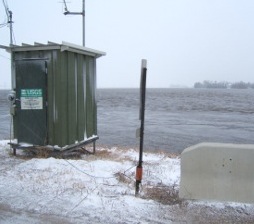 The South Branch of the Buffalo River near Sabin, Minnesota appears more like a lake during 2009 spring floods.
Report released on chloride in waters of the northern States may be of interest because of Minnesota's application of road saltWater samples from shallow wells in urban areas had the greatest concentrations of chloride, followed by water samples from agricultural and forested areas. Surface-water samples from several watersheds had chloride concentrations greater than the U.S. Environmental Protection Agency's recommended chronic criterion concentration for aquatic life. Statistical analyses showed that the density of roads, evapotranspiration and overland flow were significant factors in describing the range of maximum chloride concentrations. Reference: "Chloride in groundwater and surface water in areas underlain by the glacial aquifer system" by J. R. Mullaney, D. L. Lorenz and A. D. Arnston Contact: Dave Lorenz
Trends in nutrient and sediment concentrations in streams show signs of improvementMany actions have been taken to reduce nutrients and suspended-sediment in streams as a result of the Clean Water Act and subsequent regulations. A recently released report describes trends in concentrations and loads of nutrients and sediment in streams in the Midwest. Most forms of nitrogen, with the exception of ammonia, increased during the period from 1993-2004. The downward trend in dissolved ammonia concentrations indicates that some of the ammonia reduction goals of the Clean Water Act are being met. Flow-adjusted trends in total phosphorus concentrations were generally upward although trends in total phosphorus concentrations were mixed and showed no spatial pattern. The reduction in phosphorus fertilizer use and manure production east of the Mississippi River could explain most of the observed trends in dissolved phosphorus. Flow-adjusted trends in total suspended-material concentrations showed distinct spatial patterns of increasing tendencies in the west and decreasing concentrations in the east. Long term, non-monotonic trends in total nitrogen, total phosphorus, and suspended-material loads for 1975 to 2003 were described by local regression LOESS smoothing for six sites. The statistical significance of those trends cannot be determined; however, the long-term changes found for annual streamflow and load data indicate that the monotonic trends from 1993 to 2004 should not be extrapolated backward in time. The report was published as USGS Scientific Investigations Report 2008-5213. Contact Dave Lorenz
New report documents water-quality benefits along riparian corridors Reference: "Water Quality and Biological Characteristics and Responses to Agricultural Land Retirement in Three Streams of the Minnesota River Basin, Water Years 2006-08, USGS Scientific Investigations Report 2009-5215 Contact: Vicki Christensen
Collaborative efforts study sources of emerging contaminantsRecent work has identified emerging contaminants, including endocrine active chemicals and pharmaceutical compounds, in streams, lakes and groundwater, and other studies have raised questions about the effects of these compounds on fish. These compounds may enter the environment from wastewater treatment plants, septic-system effluent, or runoff from urban and agricultural lands. Given the large number of streams and lakes in Minnesota at risk from point and non-point sources of emerging contaminants, there is a need for relevant information concerning fish responses to chemical exposure in terms of development and reproduction. Several Water Science Center (Center) projects are providing insights about the extent of this problem at a statewide scale. Staff from the Center, the USGS National Research Program (NRP), and the USGS National Water Quality Laboratory (NWQL) are working in cooperation with St. Cloud State University, the University of St. Thomas, the University of Minnesota, and the Minnesota Pollution Control Agency to determine the fate and effects of endocrine active chemicals and pharmaceutical compounds in streams, lakes, and groundwater. Samples are being obtained from streams and lakes with varying degrees of wastewater, on-site septic tank density, or nonpoint-source influences from urban and agricultural sources. Contact: Melinda Erickson, Richard Kiesling, and Kathy Lee
A new report summarizes the occurrence and concentrations of volatile organic compounds (VOCs) in urban streams across the United StatesAs part of work conducted by the National Water-Quality Assessment Program, urban streams were monitored to characterize the stream quality from drainage basins with predominantly residential and commercial land use and to determine which selected natural and anthropogenic factors affect stream quality. VOCs were detected in 97 percent of 869 samples. Reference: "Occurrence of volatile organic compounds in selected urban streams in the United States" by D. A. Bender, G. C. Delzer, C. V. Price, and J. S. Zogorski Contact: James Fallon
National Crude Oil Spill Fate and Natural Attenuation Research Site, Bemidji Minnesota For more information contact Mindy Erickson or view the Project Website
Drawdown in Metro aquifers reflects patterns of suburban growthThe Center has completed a study to determine long-term changes in water levels in aquifers underlying the Twin Cities Metropolitan Area. The aquifers studied included the Prairie du Chien-Jordan, Franconia-Ironton-Galesville, and Mount Simon-Hinckley. The report concludes that groundwater withdrawals are increasing in the Twin Cities Metropolitan area. However, long-term (19 year) groundwater-level changes for the Prairie du Chien-Jordan and Mount Simon-Hinckley aquifers have not been large despite the substantial seasonal fluctuations in pumping. Cones of water-level depression have moved from the "downtown areas" to the southern and western suburbs. The project, conducted in cooperation with the Minnesota Department of Natural Resources, Minnesota Pollution Control Agency, and the Metropolitan Council, is documented in USGS Scientific Investigations Report (2009-5226). Contact : Chris Sanocki
Water- and Bed-Sediment Quality of Seguchie Creek and Selected Wetlands Tributary to Mille Lacs Lake in Crow Wing County, Minnesota, October 2003 to October 2006Construction of a four-lane expansion of U.S. Highway 169 has been planned along the western part of Mille Lacs Lake in Crow Wing County. Concerns exist that highway construction and related development could affect the resource quality of Mille Lacs Lake and its tributaries. The USGS, in cooperation with the Minnesota Department of Transportation, characterized the water and bed-sediment quality of selected tributaries intersecting the proposed route to document baseline conditions prior to construction. Locations monitored included Seguchie Creek upstream and downstream from the proposed route and three wetlands near Garrison. In Seguchie Creek, water no concentrations exceeded applicable water-quality standards set by the State of Minnesota. In bed sediment, constituent concentrations were compared to Interim Sediment Quality Guidelines (ISQG) set by the Canadian Council of Ministers of the Environment. Constituents that exceeded ISQGs include arsenic, cadmium, chromium, lead, and zinc, ancenaphthene, acenaphthylene, anthracene, benzo[a]anthracene, benzo[a]pyrene, chrysene, fluoranthene, fluorene, naphthalene, phenanthrene, and pyrene. In the three wetlands, concentrations exceeded ISQGs for arsenic, cadmium, chromium, copper, lead, zinc, flouranthene, phenanthrene, and pyrene. Results indicate that areas appearing relatively undisturbed and of high resource value can have degraded quality from previous unknown land use.
New and Updated Groundwater Software ReleasesThe Office of Groundwater announced the availability of a new Multi-Node Well Package for MODFLOW (MNW2) and updates to several additional groundwater software packages. Each of the packages is available through the USGS Groundwater Software webpage (http://water.usgs.gov/software/lists/groundwater/) and (or) the MODFLOW and Related Programs webpage (http://water.usgs.gov/nrp/gwsoftware/modflow.html). New releases include the following:
A new fact sheet "U.S. Geological Survey Groundwater Modeling Software: Making Sense of a Complex Natural Resource" is also now available online at http://pubs.usgs.gov/fs/2009/3105/. Contact: Melinda Erickson |
![]() U.S. Department of the Interior |
U.S. Geological Survey
U.S. Department of the Interior |
U.S. Geological Survey
URL: http://mn.water.usgs.gov/about/newsletter/winter2009/index.html
Page Contact Information: Webmaster
Page Last Modified: Wednesday, 23-Jun-2010 12:41:16 EDT


