Minnesota Water Science Center
Minnesota PROJECTSABOUT THE MINNESOTA
|
Midwest Mining Initiative / TESNAR 2011USGS Midwest Mining Initiative / TESNAR workshop - Understanding the Impacts of Mining in the Western Lake Superior region (Minnesota, Wisconsin, and Michigan), September 12-14, 2011, Bad River Lodge, Casino, and Convention Center
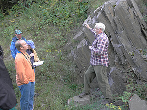
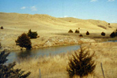
During the afternoon of the third day, a field trip was done covering the geology, geomorphology, and environmental monitoring in the Bad River watershed. The objective of the field trip was to present the geology of the area and provided a "hands-on" experience with baseline characterization of potential mining environments and associated monitoring designs and equipment. The field trip consisted of three stops. The first was at Copper Falls State Park where Tom Fitz (Northland College), Bill Cannon (USGS), and Laurel Woodruff (USGS) described the geology and Bad River geomorphology in the park. The second stop visited outcrops of the Palms Formation and Ironwood Iron-Formation along Ballou Creek, where Bill Cannon (USGS) and Klaus Schulz (USGS) described the geology of the formations. The third and final stop was at a streamgage on Tyler Forks where Krista Stensvold (USGS), Andrew Lindlof (USGS), Matt Hudson (Bad River Watershed Association), John Coleman (Great Lakes Indian Fish and Wildlife Commission), and Laurel Woodruff (USGS) presented information on the monitoring of streamflow, bed-sediment chemistry, and water quality on Tyler Forks. |
![]() U.S. Department of the Interior |
U.S. Geological Survey
U.S. Department of the Interior |
U.S. Geological Survey
URL: http://mn.water.usgs.gov/projects/tesnar/2011/index.html
Page Contact Information: Webmaster
Page Last Modified: Tuesday, 27-Sep-2011 15:58:52 EDT