Minnesota Water Science Center
Minnesota PROJECTSABOUT THE MINNESOTA
|
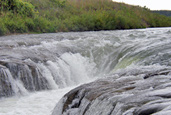
Project Title: Hydrographic Surveys of Four Pinch Points in the Namakan Reservoir System, MN Project Objectives: Conduct bathymetric and velocimetric surveys of the four pinch points in the Namakan Reservoir System: Namakan, Harrison, King Williams, and Little Vermilion Narrows. Collect lake water levels in each of the reservoir pools above, in-between, and below the narrows during the open-water periods of 2011 and 2012. Compile data for Environment Canada for development of a HEC-RAS model of the Namakan Reservoir System. Progress During FY11: The proposal was accepted and funded by the International Watershed Initiative of the International Joint Commission. Research permits with the National Park Service and the U.S. Forest Service were obtained. Remote Area Border Crossing Permits were obtained from both U.S. and Canadian Customs. Bathymetric and velocimetric surveys of the four narrows were completed. Reference elevations for the bathymetric surveys were obtained as was bathymetry data collection. Environment Canada staff joined, joined the survey crew and provided input for study design based on the requirements of the HEC-RAS model. Based on this input the number of velocity transects were reduced for the velocimetric surveys of each narrow. Water velocities were generally low, highly variable, and easily affected by boat traffic and wind. Therefore, only selected constrictions within each individual narrow were profiled for velocities. Velocity profiling was done using a boat-mounted ADCP. Stage-recording pressure transducers were deployed in three of the Namakan Reservoir pools (Little Vermilion Lake above Little Vermilion Narrows, in Sand Point Lake above Harrison Narrows, and in Sand Point Lake below Harrison Narrows). Because the narrows are culturally-significant areas, the process of obtaining research permits became difficult. Statement of Work for FY12: Transducers were removed in November 2011. Work will focus on data processing and analysis. Data will be used to plan data collection efforts for the open-water period of 2012. Water levels are controlled by the dam at Kettle Falls, and preliminary results suggest that discharges between pools of the Namakan Reservoir are highly variable in direction and magnitude during periods of stable dam operation. Therefore, the most important times for data collection are during times when dam operations are changing to accommodate the 2000 Rule Curve enforced by the IJC. The largest change in stage occurs in April and May, when water levels raise dramatically, coinciding with the spring thaw. Therefore, transducers will be deployed in the pools as soon as ice is out enough to ensure the safety of both people and equipment. A field crew will return to the Namakan Reservoir in the middle of summer to download transducer data, check installations, and replace transducer batteries. A final trip will be made at the end of the open-water period to remove transducers before ice-up. Data will be processed during the first quarter of FY2013 and given to Environment Canada for model development. |
![]() U.S. Department of the Interior |
U.S. Geological Survey
U.S. Department of the Interior |
U.S. Geological Survey
URL: http://mn.water.usgs.gov/projects/description/NQ0000115.html
Page Contact Information: Webmaster
Page Last Modified: Wednesday, 14-Dec-2011 17:12:12 EST

