Project Title: Assessing Groundwater Changes in the Vicinity of Devils Lake, North Dakota
Project Number: 8607DRO - MN 256
Project Chief: Jones, Perry M.
Project Start Date: January 2009
Project End Date: September 2010
Cooperators: U.S. Army Corps of Engineers (USACE)

Statement of Problem:
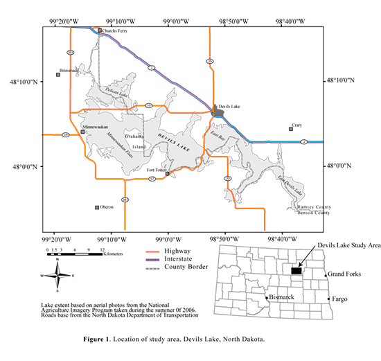
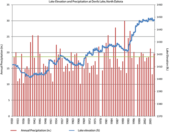
For the past several decades, annual precipitation in the Devils Lake area of North Dakota (figure 1) has exceeded the long-term average. This above-average precipitation has resulted in increased runoff to streams, lakes and wetlands and has increased recharge to the groundwater system. As a result, water levels in Devils Lake, North Dakota, have generally increased since the 1940’s (figures 2 and 3) (http://nd.water.usgs.gov/devilslake/index.html). The City of Devils Lake is protected from flooding by a series of earthen embankments. Because of increased lake levels, increased precipitation and recharge and embankment construction, groundwater levels in the City of Devils Lake are rising and may have caused intermittent flooding of basements and low-lying areas. Planned increases in the height of the embankments may result in increased groundwater levels on the upland sides of the embankments. The U.S. Geological Survey, in cooperation with the U.S. Army Corps of Engineers, is outlining a process for describing a study to fully examine the potential for groundwater changes associated with embankments-elevation change.
Objectives:
The main objective is to develop a detailed proposal to assess groundwater-level changes in the vicinity of the City of Devils Lake that may result from rising water levels in Devils Lake.
Relevance and Impact:
The results of this study would provide scientific understanding to decision makers about the effects of the construction of embankments on groundwater levels near Devils Lake. Elements from the detailed proposal could also be used to provide insights into groundwater conditions near other lakes experiencing water-level rises.

Figure 2 – Annual Precipitation and Lake Elevations for Devils Lake, North Dakota. Progress During FY10
The project chief completed the administrative report summarizing results from groundwater-flow models and outlining a proposed monitoring and modeling approach to better assess the impact of level changes in Devils Lake on surrounding groundwater resources. The project chief received and addressed technical comments in a draft copy of the report. The draft copy of the report was approved by the USGS Central Region. A copy of the final administrative report was formatted. On March 16, a final copy of the administrative report was sent to Terry Jorgensen, USACE, to complete the project.
Plans for next FY11:
The report and project folder will be archived.

Figure 3 – Shoreline locations for Devils Lake, North Dakota, 1949-2006. | 


