USGS - science for a changing world

Minnesota Water Science Center

  Home   Information/Data   Projects   Publications   Flood   NAWQA   Office   Contact   Other USGS [an error occurred while processing this directive]   Internal

Minnesota PROJECTS

ABOUT THE MINNESOTA
WSC

USGS IN YOUR STATE

USGS Water Science Centers are located in each state.

There is a USGS Water Science Center office in each State. Washington Oregon California Idaho Nevada Montana Wyoming Utah Colorado Arizona New Mexico North Dakota South Dakota Nebraska Kansas Oklahoma Texas Minnesota Iowa Missouri Arkansas Louisiana Wisconsin Illinois Mississippi Michigan Indiana Ohio Kentucky Tennessee Alabama Pennsylvania West Virginia Georgia Florida Caribbean Alaska Hawaii New York Vermont New Hampshire Maine Massachusetts South Carolina North Carolina Rhode Island Virginia Connecticut New Jersey Maryland-Delaware-D.C.

Project Title: Fate and Transport of Petroleum Hydrocarbons in Ground Water, Cass Lake, Minnesota
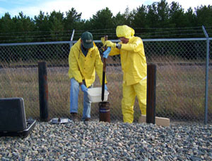
Project Number: 8607CXW - MN 246
Project Chief: Hansen, Donald S.
Project Start Date: June 2007
Project End Date: September 2009


Statement of Problem:


Water Science Center and NRP staff continues research by studying crude-oil contamination beneath the Enbridge Energy Corporation’s Cass Lake pumping station area. The site is within the Reservation of the Leech Lake Band of Ojibwe (Band) and is about 25 miles for the Bemidji research site.

The glacial outwash aquifer beneath the site consists of moderately well-sorted fine to medium-grained sands and silts to a depth of greater than 40 ft. Depth to the water table generally ranges from 26 to 29 ft below land surface. Ground-water movement is generally from northwest to southeast toward a wetland and a stream Water-table gradients are about 0.03 – 0.1 percent. Slug tests conducted indicate a mean hydraulic conductivity of about 20 feet per day. The ground-water flow velocity is estimated to be about 30 feet per day with an effective porosity of 0.25. Total organic carbon content of the aquifer matrix is 920 micrograms per kilogram. A network of wells was installed to monitor water quality at the site and to aid in evaluating the extent and nature of the contamination. In addition, a series of push-probe holes were used to investigate the extent of the dissolved and free-phase plumes. Approximately 48,000 gallons of crude oil were estimated to be floating on the water table at the site and crude-oil thicknesses were greater than 1.0 foot in selected wells. The floating crude oil extends to the southeast. The density of the crude oil varies from 0.85 to 0.938 grams per cubic centimeter. The wide range in viscosity and density likely is a reflection that crude oil resulted from batches of oil. The floating oil is estimated to be moving at a rate of 0.5 feet per year. Current remediation at the site consists of bailing oil from the monitoring wells, with a total of about 2.5 gallons being removed each month (Wenck Associates, 2006).

Objectives:


The objectives of this study are to: (1) Delineate the plume of dissolved petroleum hydrocarbons at the South Cass Lake pumping station in three dimensions; (2) Characterize the redox zones in the Cass Lake plume and use this to evaluate the depletion rate of the natural attenuation capacity of the aquifer; and (3) Estimate ground-water recharge to evaluate the possible effects of focused recharge on enhanced biodegradation of petroleum hydrocarbons. The study approach is to use the push-probe technique to investigate a series of vertical profiles at increasing distance down gradient, followed by field gas chromatograph (GC) to quantify BTEX concentrations, and then use these results to evaluate the existing well monitoring network
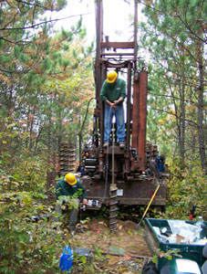
Relevance and Impact:


This proposed project is relevant to the USGS mission by addressing the priority issue “Fate and transport of anthropogenic compounds through hydrologic systems.” The proposed studies, based on long-standing USGS research at the Pinewood, Minnesota site would extend the results and fill in the gaps of previous data collection studies conducted by Enbridge and its consultants. Comparison of the research results from the Cass Lake site to that at the Pinewood site will expand our knowledge of the behavior of contaminants at petroleum hydrocarbon spill sites and thus benefit the scientific community.

Progress and Significant Results Since Last Reporting Date:


The U.S. Geological Survey (USGS) investigated the natural attenuation of petroleum hydrocarbons at the Enbridge Energy Limited Partnership South Cass Lake Pumping Station, in Cass Lake, Minnesota. Three weeks of field work were conducted between May, 2007 and July, 2008 to delineate the dissolved plume of benzene and characterize the biodegradation processes. Field activities included the installation of monitoring wells; collection of sediment cores, sampling of wells, and measurement of water-table elevations. Analytical results consist of grain-size distributions and concentrations of spilled and pipeline oil constituents, dissolved alkylbenzenes and redox constituents in groundwater, sediment bioavailable iron, and aquifer microbial populations. Groundwater flow was determined to be east-southeast at approximately 23 meters per year (m/yr). Results from the oil analyses indicate a high degree of biodegradation characterized by nearly complete absence of n-alkanes. All of the Cass Lake oil samples are highly degraded compared to two oil samples collected in 2008 from the similarly-contaminated USGS Bemidji, MN, research site located 40 kilometers (km) away. To determine if the Cass Lake oil came from the same source as the Bemidji oil, the Cass Lake pipeline sample was compared to an archived Bemidji source oil sample. Based on nineteen ratios developed for comparing oil sources, the conclusion is that the two oils are from the same source.

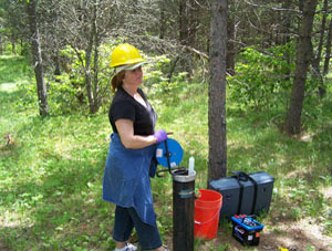
In the groundwater plume, benzene concentrations decrease by three orders of magnitude within 150 meters (m) downgradient from the floating oil body (between wells MW-10 and USGS-4 well nest). The depths of the highest benzene concentrations increase with distance downgradient from the oil, which is typical of plumes in shallow, unconfined aquifers. Background groundwater is nearly saturated with oxygen, whereas groundwater in the plume is almost entirely anaerobic. Like the Bemidji site, the most important biodegradation processes are anaerobic and dominated by iron reduction. The similarity between the Cass Lake and Bemidji benzene degradation rates, redox conditions, and aquifer material all support a hypothesis that the Cass Lake plume is decades old.

As concentrations of alkylbenzenes in the oil decrease over time, the benzene concentration in the groundwater plume will also decrease and eventually the plume is expected to shrink. Predicting the length of time required for the dissolution rate to slow to the point where the plume begins to shrink is a topic of active research at the Bemidji site. The Fox Creek wetland, located about 250 m south of the Cass Lake site, is the nearest receptor (building, surface water, or wells) south of the Cass Lake site. Based on data collected during this study and results from the Bemidji research, neither the dissolved plume nor the floating oil body is an immediate threat to the environment of Fox Creek or other receptors.

Plans for Next Reporting Date:


Publish the final report and present findings to the Leech Lake Band of Ojibwe

USGS Home Water Climate Change Core Science Ecosystems Energy and Minerals Env. Health Hazards

Accessibility FOIA Privacy Policies and Notices

USA.gov logo U.S. Department of the Interior | U.S. Geological Survey
URL: http://mn.water.usgs.gov/projects/description/8607CXW.html
Page Contact Information: Webmaster
Page Last Modified: Thursday, 07-Jan-2010 14:19:09 EST

05311000: Flow=985cfs,Stage=5.29ft,Floodstage=14ft,2024-02-26 17:00,>90,MINNESOTA RIVER AT MONTEVIDEO, MN 05301000: Flow=997cfs,Stage=24.10ft,2024-02-26 17:00,>90,MINNESOTA RIVER NEAR LAC QUI PARLE, MN 05292000: Flow=202cfs,Stage=2.64ft,Floodstage=10ft,2024-02-26 17:30,>90,MINNESOTA RIVER AT ORTONVILLE, MN 05129290: Flow=79.6cfs,Stage=14.40ft,Floodstage=20.5ft,2024-02-26 17:30,>90,GOLD PORTAGE OUTLET FROM KABETOGAMA LK NR RAY,MN 05344500: Flow=12800cfs,2024-02-26 16:55,Stage=25.36ft,2024-02-26 17:15:00,76-90,MISSISSIPPI RIVER AT PRESCOTT, WI 05340500: Flow=2800cfs,Stage=3.27ft,2024-02-26 17:00,76-90,ST. CROIX RIVER AT ST. CROIX FALLS, WI 05315000: Flow=50.7cfs,Stage=7.39ft,Floodstage=14ft,2024-02-26 17:00,76-90,REDWOOD RIVER NEAR MARSHALL, MN 05288500: Flow=6750cfs,Stage=3.37ft,Floodstage=12ft,2024-02-26 17:00,76-90,MISSISSIPPI RIVER AT HWY 610 IN BROOKLYN PARK, MN 05270500: Flow=199cfs,Stage=0.97ft,Floodstage=6ft,2024-02-26 17:15,76-90,SAUK RIVER NEAR ST. CLOUD, MN 05267000: Flow=4100cfs,Stage=9.50ft,2024-02-26 17:15,76-90,MISSISSIPPI RIVER NEAR ROYALTON, MN 05457000: Flow=64.2cfs,Stage=2.76ft,Floodstage=10ft,2024-02-26 17:00,25-75,CEDAR RIVER NEAR AUSTIN, MN 05385500: Flow=132cfs,Stage=1.96ft,2024-02-26 17:30,25-75,SOUTH FORK ROOT RIVER NEAR HOUSTON, MN 05385000: Flow=472cfs,Stage=3.16ft,Floodstage=15ft,2024-02-26 17:45,25-75,ROOT RIVER NEAR HOUSTON, MN 05345000: Flow=38.1cfs,Stage=2.32ft,2024-02-26 17:15,25-75,VERMILLION RIVER NEAR EMPIRE, MN 05333500: Flow=1050cfs,Stage=1.07ft,Floodstage=7ft,2024-02-26 17:00,25-75,ST. CROIX RIVER NEAR DANBURY, WI 05247500: Flow=858cfs,Stage=3.76ft,2024-02-26 17:45,25-75,CROW WING RIVER NEAR PILLAGER, MN 05245100: Flow=102cfs,Stage=1.87ft,Floodstage=7ft,2024-02-26 17:15,25-75,LONG PRAIRIE RIVER AT LONG PRAIRIE, MN 05129115: Flow=260cfs,Stage=5.62ft,Floodstage=14ft,2024-02-26 17:30,25-75,VERMILION RIVER NR CRANE LAKE, MN 05127500: Flow=595cfs,Stage=2.97ft,Floodstage=7.5ft,2024-02-26 17:30,25-75,BASSWOOD RIVER NEAR WINTON, MN 05125000: Flow=128cfs,Stage=2.19ft,Floodstage=6.5ft,2024-02-26 17:30,25-75,SOUTH KAWISHIWI RIVER NEAR ELY, MN 05124480: Flow=71.0cfs,Stage=3.13ft,2024-02-26 17:00,25-75,KAWISHIWI RIVER NEAR ELY, MN 05046000: Flow=339cfs,Stage=2.83ft,2024-02-26 17:30,25-75,OTTER TAIL RIVER BL ORWELL D NR FERGUS FALLS, MN 06604000: Stage=13.22ft,Floodstage=16ft,2024-02-26 17:15,Not ranked,Spirit Lake near Orleans, IA 06483290: Stage=7.20ft,2024-02-26 17:15:00,Floodstage=13ft,Not ranked,Ice affected,Rock River below Tom Creek at Rock Rapids, IA 06482610: Stage=1.89ft,2024-02-26 16:45:00,Floodstage=8.5ft,Not ranked,Ice affected,SPLIT ROCK CREEK AT CORSON,SD 05476000: Stage=7.67ft,2024-02-26 17:30:00,Floodstage=12ft,Not ranked,Ice affected,DES MOINES RIVER AT JACKSON, MN 05475350: Stage=10.68ft,Floodstage=19ft,2024-02-26 17:15,Not ranked,Ice,DES MOINES RIVER ABOVE WINDOM, MN 05388250: Stage=6.58ft,2024-02-26 17:00:00,Floodstage=14ft,Not ranked,Ice affected,Upper Iowa River near Dorchester, IA 05387030: Stage=6.61ft,2024-02-26 17:30,Not ranked,CROOKED CREEK AT FREEBURG MN 05386400: Stage=30.94ft,2024-02-26 17:45,Not ranked,MISSISSIPPI RIVER AT BROWNSVILLE, MN 05384350: Stage=8.25ft,Floodstage=21ft,2024-02-26 17:00,Not ranked,ROOT RIVER ABOVE RUSHFORD, MN 05383950: Stage=7.67ft,2024-02-26 17:00:00,Floodstage=19ft,Not ranked,Ice affected,ROOT RIVER NEAR PILOT MOUND, MN 05383075: Flow=318cfs,Stage=2.50ft,Floodstage=7.5ft,2024-02-26 17:00,Not ranked,LA CROSSE RIVER NEAR LA CROSSE, WI 05378500: Stage=5.71ft,2024-02-26 17:45:00,Floodstage=13ft,Not ranked,Ice affected,MISSISSIPPI RIVER AT WINONA, MN 05378490: Stage=5.97ft,Floodstage=655ft,2024-02-26 17:15,Not ranked,MISSISSIPPI RIVER AT LOCK AND DAM 5A NR WINONA, MN 05374000: Stage=5.23ft,Floodstage=18ft,2024-02-26 17:30,Not ranked,ZUMBRO RIVER AT ZUMBRO FALLS, MN 05372995: Stage=2.38ft,2024-02-26 17:15:00,Floodstage=14ft,Not ranked,Ice affected,SOUTH FORK ZUMBRO RIVER AT ROCHESTER, MN 05355250: Stage=2.93ft,2024-02-26 17:15:00,Floodstage=14ft,Not ranked,Seasonal site,MISSISSIPPI RIVER AT RED WING, MN 05355200: Stage=3.39ft,2024-02-26 17:00:00,Not ranked,Ice affected,CANNON RIVER AT WELCH, MN 05355092: Flow=167cfs,Stage=7.33ft,2024-02-26 17:50,Not ranked,CANNON RIVER AT 9TH ST. BRIDGE IN CANNON FALLS, MN 05355080: Stage=11.92ft,2024-02-26 17:15,Not ranked,PRAIRIE CREEK NEAR CANNON FALLS, MN 05355038: Stage=5.25ft,2024-02-26 17:30,Not ranked,CHUB CREEK AT CO. HWY. 47 ABOVE RANDOLPH, MN 05355024: Flow=128cfs,Stage=889.76ft,Floodstage=897ft,2024-02-26 17:30,Not ranked,CANNON RIVER AT NORTHFIELD MN 05354500: Stage=8.94ft,2024-02-26 17:15:00,Not ranked,Seasonal site,CANNON RIVER AT CO. HWY. 29 BELOW FARIBAULT, MN 05353800: Stage=3.77ft,2024-02-26 17:15:00,Not ranked,Ice affected,STRAIGHT RIVER NEAR FARIBAULT, MN 05344490: Flow=3650cfs,Stage=25.36ft,2024-02-26 17:15,Not ranked,ST. CROIX RIVER AT PRESCOTT, WI 05342000: Flow=91.8cfs,Stage=8.18ft,2024-02-26 17:30,Not ranked,KINNICKINNIC RIVER NEAR RIVER FALLS, WI 05341550: Stage=675.67ft,2024-02-26 17:15:00,Floodstage=687.00ft,Not ranked,Ice affected,ST. CROIX RIVER AT STILLWATER, MN 05338500: Stage=3.19ft,2024-02-26 17:15:00,Floodstage=9ft,Not ranked,Ice affected,SNAKE RIVER NEAR PINE CITY, MN 05336700: Stage=4.23ft,2024-02-26 17:00:00,Not ranked,Ice affected,KETTLE RIVER BELOW SANDSTONE, MN 05331580: Flow=9020cfs,Stage=7.18ft,2024-02-26 16:55,Not ranked,MISSISSIPPI RIVER BELOW L&D 2 AT HASTINGS, MN 05331000: Stage=3.36ft,2024-02-26 17:00:00,Floodstage=14ft,Not ranked,Ice affected,MISSISSIPPI RIVER AT ST. PAUL, MN 05330000: Stage=6.49ft,2024-02-26 17:45:00,Floodstage=25ft,Not ranked,Ice affected,MINNESOTA RIVER NEAR JORDAN, MN 05327000: Stage=3.36ft,2024-02-26 17:00:00,Not ranked,Seasonal site,HIGH ISLAND CREEK NEAR HENDERSON, MN 05325000: Stage=4.38ft,2024-02-26 17:30:00,Floodstage=22ft,Not ranked,Ice affected,MINNESOTA RIVER AT MANKATO, MN 05320500: Stage=1.77ft,2024-02-26 17:00:00,Not ranked,Ice affected,LE SUEUR RIVER NEAR RAPIDAN, MN 05320000: Stage=1.87ft,2024-02-26 16:45:00,Not ranked,Ice affected,BLUE EARTH RIVER NEAR RAPIDAN, MN 05319500: Stage=1.25ft,2024-02-26 17:30:00,Not ranked,Ice affected,WATONWAN RIVER NEAR GARDEN CITY, MN 05317200: Stage=2.31ft,2024-02-26 17:15:00,Not ranked,Ice affected,LITTLE COTTONWOOD RIVER NEAR COURTLAND, MN 05317000: Stage=4.30ft,2024-02-26 17:00:00,Floodstage=11ft,Not ranked,Ice affected,COTTONWOOD RIVER NEAR NEW ULM, MN 05316770: Stage=787.64ft,2024-02-26 17:45:00,Floodstage=800ft,Not ranked,Ice affected,MINNESOTA RIVER AT NEW ULM, MN 05316580: Flow=1470cfs,Stage=10.86ft,Floodstage=21ft,2024-02-26 17:00,Not ranked,MINNESOTA RIVER AT MORTON, MN 05316500: Stage=2.35ft,2024-02-26 17:00:00,Floodstage=6ft,Not ranked,Ice affected,REDWOOD RIVER NEAR REDWOOD FALLS, MN 05313500: Stage=3.39ft,2024-02-26 17:45:00,Not ranked,Ice affected,YELLOW MEDICINE RIVER NEAR GRANITE FALLS, MN 05311150: Flow=634cfs,2023-11-15 05:45,Stage=881.02ft,2024-02-26 17:15:00,Floodstage=885ft,Not ranked,MINNESOTA RIVER AT HWY 212 IN GRANITE FALLS, MN 05305000: Stage=36.11ft,2024-02-26 17:00:00,Not ranked,Ice affected,CHIPPEWA RIVER (TW) NEAR WATSON, MN 05304995: Stage=39.57ft,2024-02-26 17:00,Not ranked,CHIPPEWA R. (HW) ABOVE COUNTY RD 13 NR WATSON, MN 05304500: Stage=1.64ft,2024-02-26 17:45:00,Not ranked,Ice affected,CHIPPEWA RIVER NEAR MILAN, MN 05300000: Stage=7.06ft,2024-02-26 17:45:00,Not ranked,Ice affected,LAC QUI PARLE RIVER NEAR LAC QUI PARLE, MN 05294000: Stage=5.18ft,2024-02-26 17:00:00,Not ranked,Ice affected,POMME DE TERRE RIVER AT APPLETON, MN 05293000: Stage=2.98ft,2024-02-26 17:15:00,Not ranked,Ice affected,YELLOW BANK RIVER NEAR ODESSA, MN 05291000: Stage=1.84ft,2024-02-26 17:45:00,Floodstage=12ft,Not ranked,Ice affected,WHETSTONE RIVER NEAR BIG STONE CITY, SD 05290000: Stage=10.92ft,2024-02-26 17:00:00,Floodstage=17ft,Not ranked,Ice affected,LITTLE MINNESOTA RIVER NEAR PEEVER, SD 05289800: Stage=12.03ft,2024-02-26 17:00:00,Not ranked,Ice affected,MINNEHAHA CREEK AT HIAWATHA AVE. IN MINNEAPOLIS,MN 05289100: Stage=925.22ft,2024-02-26 17:00,Not ranked,MINNEHAHA CREEK BLW GRAYS BAY DAM IN MINNETONKA MN 05289000: Stage=928.73ft,2024-02-26 17:00,Not ranked,LAKE MINNETONKA ABV GRAYS BAY OTLT IN MINNETONKA 05288705: Stage=9.16ft,2024-02-26 17:00:00,Not ranked,Ice affected,SHINGLE CREEK AT QUEEN AVE IN MINNEAPOLIS, MN 05288670: Stage=89.44ft,Floodstage=16ft,2024-02-26 17:30,Not ranked,MISSISSIPPI RIVER ABV 37TH AVE. NE IN FRIDLEY, MN 05288580: Stage=6.29ft,2024-02-26 17:00:00,Not ranked,Ice affected,RICE CREEK BLW OLD HWY. 8 IN MOUNDS VIEW, MN 05287890: Stage=3.95ft,2024-02-26 17:00:00,Not ranked,Ice affected,ELM CREEK NR CHAMPLIN, MN 05286000: Stage=2.83ft,2024-02-26 17:00:00,Floodstage=8ft,Not ranked,Ice affected,RUM RIVER NEAR ST. FRANCIS, MN 05284000: Stage=10.75ft,2024-02-26 17:15,Not ranked,MILLE LACS LAKE AT COVE BAY NEAR ONAMIA, MN 05283500: Stage=4.55ft,2024-02-26 17:30:00,Floodstage=12ft,Not ranked,Ice affected,MISSISSIPPI RIVER AT US HWY 169 AT CHAMPLIN, MN 05280000: Stage=3.25ft,2024-02-26 17:00:00,Floodstage=10ft,Not ranked,Ice affected,CROW RIVER AT ROCKFORD, MN 05275000: Stage=1.01ft,2024-02-26 17:15:00,Not ranked,Ice affected,ELK RIVER NEAR BIG LAKE, MN 05270700: Stage=4.80ft,2024-02-26 16:45:00,Floodstage=9ft,Not ranked,Ice affected,MISSISSIPPI RIVER AT ST. CLOUD, MN 05244000: Stage=2.69ft,2024-02-26 17:00:00,Not ranked,Ice affected,CROW WING RIVER AT NIMROD, MN 05243725: Stage=1.16ft,2024-02-26 17:30:00,Not ranked,Ice affected,STRAIGHT RIVER NEAR PARK RAPIDS, MN 05242300: Stage=5.97ft,2024-02-26 17:30:00,Floodstage=16ft,Not ranked,Back Water,MISSISSIPPI RIVER AT BRAINERD, MN 05227530: Not ranked,Equipment malfunction,MISSISSIPPI RIVER DIVERSION NEAR AITKIN, MN 05227500: Stage=6.44ft,2024-02-26 17:30:00,Floodstage=13ft,Not ranked,Back Water,MISSISSIPPI RIVER AT AITKIN, MN 05212700: Stage=2.57ft,2024-02-26 17:45:00,Floodstage=10ft,Not ranked,Ice affected,PRAIRIE RIVER NEAR TACONITE, MN 05211000: Stage=2.76ft,2024-02-26 17:15:00,Not ranked,Ice affected,MISSISSIPPI RIVER AT GRAND RAPIDS, MN 05210000: Stage=72.44ft,2024-02-26 17:30,Not ranked,MISSISSIPPI R. AT DAYS HIGH LANDING NR DEER RIVER 05207600: Stage=5.48ft,2024-02-26 17:15:00,Not ranked,Ice affected,MISSISSIPPI RIVER AT WILLOW BEACH AT BALL CLUB, MN 05205900: Stage=94.47ft,2024-02-26 17:30,Not ranked,LEECH LAKE AT SUGAR POINT NEAR FEDERAL DAM, MN 05200510: Not ranked,Seasonal site,MISSISSIPPI RIVER NEAR BEMIDJI, MN 05140521: Stage=58.25ft,2024-02-26 17:00,Not ranked,LK OF THE WOODS @ SPRINGSTEEL IS NR. WARROAD, MN 05140520: Stage=58.27ft,2024-02-26 17:30,Not ranked,LAKE OF THE WOODS AT WARROAD, MN 05137500: Stage=4.00ft,2024-02-26 17:00,Not ranked,RAINY RIVER NEAR BOAT LANDING AT WHEELERS POINT,MN 05134200: Not ranked,Equipment malfunction,RAPID RIVER NEAR BAUDETTE, MN 05133500: Stage=3.39ft,2024-02-26 17:30:00,Not ranked,Ice affected,RAINY RIVER AT MANITOU RAPIDS, MN 05132000: Stage=3.76ft,2024-02-26 17:30:00,Floodstage=16ft,Not ranked,Ice affected,BIG FORK RIVER AT BIG FALLS, MN 05131500: Stage=2.89ft,2024-02-26 17:30:00,Floodstage=22ft,Not ranked,Ice affected,LITTLE FORK RIVER AT LITTLEFORK, MN 05129515: Stage=15.12ft,2024-02-26 17:30:00,Not ranked,Ice affected,RAINY R AT BOAT LANDING BLW INTERNATIONAL FALLS,MN 05126210: Flow=259cfs,Stage=3.95ft,2024-02-26 17:30,Not ranked,SOUTH KAWISHIWI R ABV WHITE IRON LAKE NR ELY, MN 05112000: Stage=2.35ft,2024-02-26 17:30:00,Not ranked,Ice affected,ROSEAU RIVER BELOW STATE DITCH 51 NR CARIBOU, MN 05107500: Stage=2.32ft,2024-02-26 17:30:00,Not ranked,Ice affected,ROSEAU RIVER AT ROSS, MN 05106000: Not ranked,Equipment malfunction,SPRAGUE CREEK NEAR SPRAGUE, MANITOBA, CANADA 05104500: Stage=3.96ft,2024-02-26 17:00:00,Not ranked,Ice affected,ROSEAU RIVER BELOW SOUTH FORK NEAR MALUNG, MN 05102490: Stage=14.44ft,Floodstage=39ft,2024-02-26 17:30,Not ranked,RED RIVER OF THE NORTH AT PEMBINA, ND 05094000: Stage=3.40ft,2024-02-26 17:15:00,Not ranked,Ice affected,SOUTH BRANCH TWO RIVERS AT LAKE BRONSON, MN 05092000: Stage=12.91ft,2024-02-26 17:45:00,Floodstage=32ft,Not ranked,Ice affected,RED RIVER OF THE NORTH AT DRAYTON, ND 05087500: Stage=3.91ft,2024-02-26 14:00:00,Not ranked,Ice affected,MIDDLE RIVER AT ARGYLE, MN 05085450: Stage=61.87ft,2024-02-26 16:45:00,Floodstage=67ft,Not ranked,Ice affected,SNAKE RIVER ABOVE WARREN, MN 05083500: Stage=10.09ft,Floodstage=26ft,2024-02-26 17:15,Not ranked,RED RIVER OF THE NORTH AT OSLO, MN 05082500: Stage=16.58ft,2024-02-26 17:45:00,Floodstage=28ft,Not ranked,Ice affected,RED RIVER OF THE NORTH AT GRAND FORKS, ND 05080000: Stage=12.48ft,2024-02-26 17:30:00,Not ranked,Ice affected,RED LAKE RIVER AT FISHER, MN 05079000: Stage=5.02ft,2024-02-26 16:15:00,Floodstage=15ft,Not ranked,Ice affected,RED LAKE RIVER AT CROOKSTON, MN 05078500: Not ranked,Equipment malfunction,CLEARWATER RIVER AT RED LAKE FALLS, MN 05078230: Stage=3.78ft,2024-02-26 17:30:00,Not ranked,Ice affected,LOST RIVER AT OKLEE, MN 05078000: Stage=3.42ft,2024-02-26 17:15:00,Not ranked,Ice affected,CLEARWATER RIVER AT PLUMMER, MN 05076000: Stage=4.69ft,2024-02-26 17:15:00,Not ranked,Ice affected,THIEF RIVER NEAR THIEF RIVER FALLS, MN 05075000: Stage=5.30ft,2024-02-26 17:00:00,Floodstage=12ft,Not ranked,Seasonal site,RED LAKE RIVER AT HIGH LANDING NR GOODRIDGE, MN 05074500: Stage=69.65ft,2024-02-26 17:30:00,Not ranked,Ice affected,RED LAKE RIVER NEAR RED LAKE, MN 05074000: Stage=74.19ft,2024-02-26 17:30,Not ranked,LOWER RED LAKE NR RED LAKE, MN 05073500: Stage=74.07ft,2024-02-26 17:30,Not ranked,UPPER RED LAKE AT WASKISH, MN 05070000: Stage=19.32ft,2024-02-26 17:15:00,Not ranked,Ice affected,RED RIVER OF THE NORTH NEAR THOMPSON, ND 05069000: Stage=5.19ft,2024-02-26 17:45:00,Floodstage=20ft,Not ranked,Ice affected,SAND HILL RIVER AT CLIMAX, MN 05067500: Flow=0.09cfs,2023-11-30 19:45,Not ranked,MARSH RIVER NEAR SHELLY, MN 05064500: Stage=8.32ft,2024-02-26 17:30:00,Floodstage=26ft,Not ranked,Ice affected,RED RIVER OF THE NORTH AT HALSTAD, MN 05064000: Stage=5.71ft,2024-02-26 17:30:00,Floodstage=20ft,Not ranked,Ice affected,WILD RICE RIVER AT HENDRUM, MN 05063398: Stage=5.75ft,2024-02-26 17:00:00,Not ranked,Back Water,S. BR. WILD RICE RIVER AT CO. RD. 27 NR FELTON, MN 05062500: Stage=2.60ft,2024-02-26 16:45:00,Floodstage=10ft,Not ranked,Ice affected,WILD RICE RIVER AT TWIN VALLEY, MN 05062000: Not ranked,Equipment malfunction,BUFFALO RIVER NEAR DILWORTH, MN 05061500: Stage=7.00ft,2024-02-26 17:45:00,Floodstage=13ft,Not ranked,Back Water,SOUTH BRANCH BUFFALO RIVER AT SABIN, MN 05061000: Stage=3.30ft,2024-02-26 16:45:00,Floodstage=8ft,Not ranked,Ice affected,BUFFALO RIVER NEAR HAWLEY, MN 05060400: Stage=69.50ft,2024-02-26 17:15:00,Floodstage=84ft,Not ranked,Ice affected,SHEYENNE RIVER AT HARWOOD, ND 05054000: Stage=15.05ft,2024-02-26 17:15:00,Floodstage=18ft,Not ranked,Ice affected,RED RIVER OF THE NORTH AT FARGO, ND 05053000: Stage=11.08ft,2024-02-26 14:00:00,Floodstage=20ft,Not ranked,Ice affected,WILD RICE RIVER NR ABERCROMBIE, ND 05052500: Stage=24.01ft,2023-10-01 00:45:00,Not ranked,Zero flow,ANTELOPE CREEK AT DWIGHT, ND 05051522: Stage=11.68ft,2024-02-26 16:45:00,Floodstage=30ft,Not ranked,Ice affected,RED RIVER OF THE NORTH AT HICKSON, ND 05051500: Stage=5.16ft,2024-02-26 17:30:00,Floodstage=11ft,Not ranked,Ice affected,RED RIVER OF THE NORTH AT WAHPETON, ND 05051300: Stage=7.95ft,2024-02-26 17:00:00,Not ranked,Ice affected,BOIS DE SIOUX RIVER NEAR DORAN, MN 05050000: Stage=5.17ft,2024-02-26 17:30:00,Floodstage=14ft,Not ranked,Ice affected,BOIS DE SIOUX RIVER NEAR WHITE ROCK, SD 05049995: Stage=72.42ft,2024-02-26 17:30,Not ranked,MUD LAKE ABOVE WHITE ROCK DAM NEAR WHITE ROCK, SD 05049710: Stage=72.65ft,2024-02-26 17:00,Not ranked,LAKE TRAVERSE OTLT AT RESERVATION DAM NR WHEATON 05049700: Stage=77.03ft,2024-02-26 17:00,Not ranked,LAKE TRAVERSE AT RESERVATION DAM NEAR WHEATON, MN 05049000: Stage=77.05ft,2024-02-26 17:30:00,Not ranked,Seasonal site,MUSTINKA RIVER ABOVE WHEATON, MN 05046475: Stage=15.06ft,2024-01-07 00:45:00,Not ranked,Ice affected,OTTER TAIL RIVER DIVERSION AT BRECKENRIDGE, MN 05030500: Flow=334cfs,Stage=5.66ft,2024-02-26 17:00,Not ranked,OTTER TAIL RIVER NEAR ELIZABETH, MN 04024430: Stage=4.89ft,2024-02-26 17:00:00,Floodstage=24ft,Not ranked,Back Water,NEMADJI RIVER NEAR SOUTH SUPERIOR, WI 04024000: Stage=3.81ft,2024-02-26 17:30:00,Floodstage=10.5ft,Not ranked,Ice affected,ST. LOUIS RIVER AT SCANLON, MN 04021520: Stage=3.94ft,2024-02-26 17:00:00,Not ranked,Back Water,STONEY BROOK AT PINE DRIVE NEAR BROOKSTON, MN 04015438: Stage=17.60ft,2024-02-26 16:45:00,Not ranked,Ice affected,ST. LOUIS RIVER NEAR SKIBO, MN 04015330: Not ranked,Equipment malfunction,KNIFE RIVER NEAR TWO HARBORS, MN 04010500: Not ranked,Equipment malfunction,PIGEON RIVER AT MIDDLE FALLS NR GRAND PORTAGE MN Go to WaterWatch (offsite) for a larger map with additional options