Minnesota Water Science Center

RedN NAWQAUSGS IN YOUR STATEUSGS Water Science Centers are located in each state. 
|
CONCEPTS FOR AN INDEX OF BIOTIC INTEGRITY FOR STREAMS OF THE RED RIVER OF THE NORTH BASIN
Robert M. Goldstein, Thomas P. Simon, Patricia A. Bailey, Michael Ell, Eric Pearson, Konrad Schmidt, and John W. Enblom
United States Geological Survey, 2280 Woodale
Dr., Mounds View, MN 55112;
|
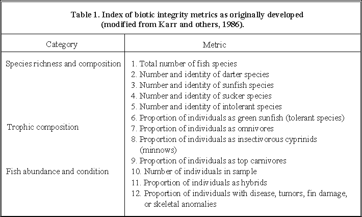
| Category | Metric |
| Species richness and composition | 1. Total number of fish species |
| 2. Number and identity of darter species | |
| 3. Number and identity of sunfish species | |
| 4. Number and identity of sucker species | |
| 5. Number and identity of intolerant special | |
| 6. Proportion of individuals as green sunfish (tolerant species) | |
| Trophic composition | 7. Proportion of individuals as omnivores |
| 8. Proportion of individuals as insectivorous cyprinids (minnows) | |
| 9. Proportion of individuals as top carnivore | |
| Fish abundance and condition | 10. Number of individuals in sample |
| 11. Proportion of individuals as hybrids | |
| 12. Proportion of individuals with disease, tumors, fin damage, or skeletal anomalies |
In the United States the water resources of the Red River of the North Basin (herein referred to as the Red River Basin) are currently managed by North Dakota, South Dakota, and Minnesota agencies in addition to the US. Environmental Protection Agency. The development of a modified IBI specific to the Red River Basin, based on multi-agency cooperation, would provide water resource managers with a common, broadly based, multi-parameter tool to evaluate biological conditions in streams. The purpose of this paper is to propose, a peon, potential metrics which may help evaluate biological conditions in the Red River Basin. This is a combined effort among the U.S. Geological Survey's National-Water Quality Assessment Program, U.S. Environmental Protection Agency (USEPA), Minnesota Pollution Control Agency (MPCA), North Dakota Department of Health and Consolidated Laboratories Water Quality Branch, and Minnesota Department of Natural Resources. Although each of the groups have different missions, they share the common goal of producing an IBI specific to the Red River Basin.
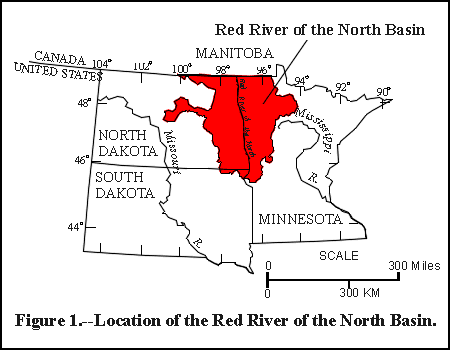
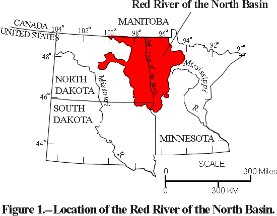
In the United States, the Red River Basin (fig. 1 below) covers over 90,000 square kilometers (km2) in the states of Minnesota, North Dakota, and South Dakota. The basin is a valued resource of international concern and an important agricultural area (Stoner and others, 1993).
Since the basin was settled, the original prairie vegetation has been cleared for production of wheat, corn, potatoes, soybeans, other small grains, and vegetables (Stoner and others, 1993). The land has been treated with fertilizers, herbicides, and insecticides to increase production. The drainage of wetlands and the creation of a massive network of drainage ditches enabled additional land to be cultivated. By 1973, over 2 million hectares (39 percent) of the land in Minnesota's portion of the basin were drained by almost 13,000 hen of drainage ditches (US. Geological Survey, 1974). Construction of numerous dams and small impoundments controlled runoff and flooding. These changes, combined with the natural climatic and hydrologic variability of the region, have helped form the environment of the Red River Basin today (Stoner and others, 1993).
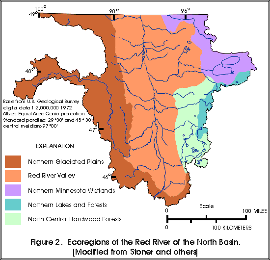
Various classification systems have been applied to land areas with the goal of identifying homogeneous areas (Bailey, 1974; Omernik, 1987). Omernik and Gallant (1988) have identified five ecoregions within the Red River of the North Basin (fig. 2 below): the Red River Valley, North Central Hardwood Forests, Northern lakes and Forests, Northern Glaciated Plains, and Northern Minnesota Wetlands. Ecoregions are defined as areas of homogeneous ecological systems or area that have the potential (if undisturbed) for similar biological communities (Omernik, 1987). Ecoregion classification is based on features which include differences in geomorphology, soils, physiography, land use and cover, and potential natural vegetation. Characteristics of the ecoregions in the Red River Basin are described by Stoner and others (1993).
Data on fish community composition were compiled from state agency reports, personal collection records, and published literature. A test analysis was made using the original IBI metrics. The IBI ratings were found to be highly correlated to river gradient (for example r=0.77 for the Red Lake River). The development of individual IBI metric expectations for the Red River Basin involved the review of previous metrics developed by Karrand others (1986), Ohio Environmental Protection Agency (1987), Steedman (1988), Lyons (1992), and Bailey and others (1993). Numerous discussions among the authors produced a list of modified metrics and new metrics. Each modified and new metric was evaluated hypothetically based on the available data. Modified or new metrics that could be supported by data were kept (table 2 below), all others were discarded. Only new metrics or modifications of existing metrics will be discussed. Each metric will be presented with its rationale.
Because of the influence of stream size on the IBI (Osborne and others, 1992), reference conditions will need to be developed for small headwater streams; mid-size tributaries; and large mainstem portions of rivers, such as the Red River of the North rnainstem and Red Lake River. Stream size classes were based on watershed area after Bailey and others (1993) and Simon (1992).
Fish communities are anticipated to reflect the differences among the five ecoregions in the Red River Basin, requiring reference fish community data from each ecoregion. Based on the number of stream size classes and ecoregions within the Red River Basin, a minimum of 15 versions of the IBI would need to be generated. After analysis of reference site fish community data, the possibility exists that some similarity among ecoregions or stream size clasps will reduce the number of versions needed. Reference conditions will be determined from the typical ecoregion Sites demonstrating least affected conditions. This will enable ecologically similar sites from adjacent ecoregions to be used to determine reference conditions for other areas.
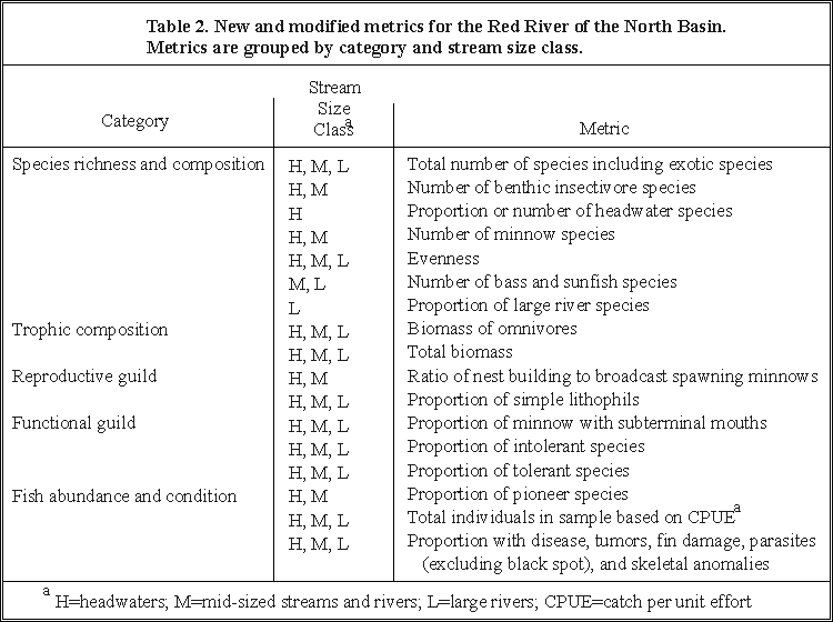
[Table 2. is available in either GIF (16 KB) or PDF (16 KB) format]
| ||
| Species richness and composition | H, M, L | Total number of species including exotic species |
| H,M | Number of benthic insectivore species | |
| H | Proportion or number of headwater species | |
| H, M | Number of minnow species | |
| H, M, L | Evenness | |
| M, L | Number of bass and sunfish species | |
| L | Proportion of large river species | |
| Trophic composition | H, M, L | Biomass of omnivores |
| H, M, L | Total biomass | |
| Reproductive guild | H, M | Ratio of nest building to broadcast spawning minnows |
| H, M, L | Proportion of simple lithophils | |
| Functional guild | H, M, L | Proportion of minnows with subtenninal mouths |
| H, M, L | Proportion of intolerant species | |
| Proportion of tolerant species | ||
| Fish abundance and condition | H, M | Proportion of pioneer species |
| H, M, L | Total individuals in sample based on CPUEa | |
| H, M, L | Proportion with disease, tumors, fin damage, parasites
(excluding black Spot), and skeletal anomalies |
a H=headwaters; M=midsized
streams and rivers; L=large rivers; CPUE=catch per unit effort
We propose 17 new or modified metrics for the Red River Basin. These metrics provide measures on multiple aspects of the fish community in five classes: species richness and composition, trophic composition, reproductive guilds (guilds as defined by Balon, 1975 and 1981), functional guilds, and fish abundance and condition.
Metric-total number of species (including exotic species). The total number of species is the species richness component of diversity (Pielou, 1975). Species richness is a function of the natural and anthropogenic changes occurring within an ecoregion. A total of 80 species of fish have been documented from the basin (Underhill, 1989), but the current assemblage, which excludes salmonids and species not collected within the last 20 years, consists of 75 species (Stoner and others, 1993). Generally, as ecological diversity (the number and kinds of organisms in a community) increases, biotic integrity improves. Although exotic species are excluded from the original metric (Plafkin and others, 1989), the carp (Cypnnus casino) is the only exotic species in the Red River Basin. Carp have been in the basin at least since the 1920's (Eddy and Underhill, 1974) and appear to be an integral part of the fish community. In some rivers, carp may constitute a substantial portion of the fish biomass (Renard and others, 1986), and their presence as an invader and replacement for native species may discriminate among the lowest levels of biological integrity. As such, they are an integral part of the fish community and will be included as part of this metric.
Metric-the number of benthic insectivore species. Benthic insectivores are those fish species associated with riffle habitats over clean gravel substrates that feed primarily on insects. This metric is a replacement for the number of darter species in the original IBI (table 1). Headwater sites in the basin do not have appreciable numbers of darter species. Review of species distribution data indicated that only three species of darters have been collected from North Dakota (Ryckman, 1981). The original concept for this metric was to include additional benthic insectivore species such as madtom (Noturus spp.)and sculpin (Cottus spp.) (Ohio Environmental Protection Agency, 1987; Simon, 1990) if darters were few or absent. The madtom occupy a niche similar to darters (sculpins are absent in the Red River Basin). Other benthic insectivores in the Red River Basin include silver redhorse (Moxostoma anisurum), golden redhorse (M. erythurum), shorthead redhorse (M. macrolepidotum), and greater redhorse (M. valenciennesi), silver chub (Macrhybopsis storeriana), bigmouth shiner (Notropis dorsalis), sand shiner (N. stramineus), mimic shiner (N. volucellus), longnose dace (Rhinichthys cataractae), blacknose dace (R. atratulus), and trout-perch (Pecrcopsis omiscomaycus). An increase in benthic insectivore species is hypothesized to correlate with increased biotic integrity.
Metric-proportion or number of headwater species. Ohio Environmental Protection Agency (1987) and Simon (1990) demonstrated that certain fish assemblages inhabit headwater streams with drainage areas under 50 km2. Pool habitat tends to be a limiting factor in many headwater streams prohibiting colonization by sunfish (Lepomis spp.). Nine species have been designated as headwater taxa (Ohio Environmental Protection Agency, 1987; Simon, 1990). Headwater species in the Red River Basin include pearl dace (Margariscus margarita), northern redbelly dace (Phoxinus eos), finescale dace (P. neogaeus), blacknose dace, and brook stickleback (Culaea inconstans). The presence of headwater fish species are associated with permanent habitat with low environmental stress and an increase in biotic integrity (Ohio Environmental Protection Agency, 1987; Simon, 1990).
Metric-number of minnow species. The number of minnow species has been associated with increased environmental quality and biotic integrity. The number and kinds of minnow species reflect biological integrity at both ends of the integrity continuum As many as ten minnow species may be present in headwater streams with drainage areas under 50 km2. Species such as the hornyhead chub (Nocomis bigutattus), sand shiner (Notropis stramineus), and roseyface shiner (N. rubellus) are exernples of minnows which occur in high quality areas. Species such as creek chub (Semotilus atromaculatus), fathead minnow (Pimephales promelas), and golden shiner (Notemigonus crysoleucas) are tolerant to both chemical degradation and stream desiccation.
Metric-evenness. Evenness describes the distribution of abundance of individuals among species (Pielou, 1975). Evenness compares the observed diversity to a theoretical maximum diversity. If all species have equal abundance, the distribution of abundances has maximum evenness. The greater the differences in abundance, the smaller the evenness.
In many cases where environmental degradation has occurred, one species in the community has been able to increase its numbers while other species have declined. Those species with the capacity to capitalize on a change in physical or chemical enviromnents are usually tolerant species. Their relative abundance increases and skews evenness such that without a loss of species (species richness) total diversity declines due to the reduction in evenness. In other cases, an environment is degraded or habitat altered allowing an exotic species to invade and become established.
In the case of a stream where degradation has allowed tolerant or exotic species to increase in abundance to the detriment of the other species, evenness would decrease as the proportion of tolerant species increased. Using evenness as the metric rather than the proportion of tolerant species precludes the necessity of developing a list of tolerant species. This aspect of the metric is a positive one for the Red River basin where so many of the species would be considered tolerant. Plafkin and others (1989) list twelve tolerant Midwestern species. Eleven are recorded from the Red River Basin. It is reasonable to hypothesize that the extremes of temperature, short growing season, and variability in discharge have produced an environment where many of the species could be classified as tolerant species. Reduced evenness indicates a loss of biotic integrity.
Metric-number of sunfish species including bass. An increase in the number of sunfish species indicates an increase in biotic integrity. This metric evaluates the abundance and quality of pool habitat based on sunfish which are primarily pool dwellers (Kerr and others, 1986). The number of sunfish species also indicates the status of midwater feeders and, therefore, gives an indication of the abundance and quality of invertebrate drift. In the original IBI (table 1), bass (Micropterus spp.) were excluded. In the Red River Basin there have been nine species of sunfish reported including two bass. The orange spotted sunfish (Loomis humilis) has been reported from North Dakota rivers in the Red River Basin, but only in several smaller tributaries in Minnesota. Several species of bass and sunfish have been stocked throughout the basin in various locations to increase sport fishing.
One of the most common changes to habitat which has occurred in the Red River Basin is the straightening of channels and reduction of pool habitat. This proposed metric is used to evaluate those environmental changes. The habitat requirements of bass are similar to the other sunfish. While the trophic guild of age 1 and older bass may not be the same as sunfish, it is comparable while the bass are small (<100 millimeters total length) and may overlap at larger sizes depending on the availability of food items (Keast and Eadie, 1985). Spawning requirements, in terms of habitat for nest location and construction, are similar for bass and sunfish (Eddy and Underhill, 1974). To increase resolution of the metric, bass are included in this metric because the critical survival factors are similar to sunfish
Metric-proportion of large river species. Few metrics have been proposed or tested for large river habitats such as the Red River of the North or Red Lake River. Simon (1992) recognized two categories of large rivers based on drainage area: large rivers (2500-5000 km2) and great rivers (>5000 km2). Hughes and Gammon (1987) evaluated a series of potential metrics for large rivers in the Willamette River basin whereas Simon (1992) described metrics designed for large rivers in Indiana. The number of large river fish taxa is expected to increase in rivers with drainage areas greater than 5000 km2. A lower proportion of large river taxa suggests a loss of biological integrity in large and great river habitats.
Just as darter, madtom, and sculpin are characteristic of small streams, so certain species are commonly found in large river habitats. Pflieger (1971), Burr and Warren (1986), and Simon (1992) found that a characteristic fish faunal assemblage was apparent in large and great river habitats. Pflieger (1971) designated this an important ichthyofaunal zone for fish in Missouri. Simon (1992) found that certain fish species such as sturgeon (Acipenseridae), gar (Lepisosteidae), river shiner (Notropis blennius), carpsuckers (Carpiodes spp.), buffalo (Ictiobus spp.), channel catfish (Ictalurus punctatus), and some chubs (Cyprinidae) appeared in greater abundance at drainage areas of about 5000 km2.
These metrics are designed to focus on energy flow through the system and how it may be changed by degradation of the environment. Rather than use the proportion of individuals (omnivores, insectivores, benthic insectivores and top carnivores) as the metric, the proportion of biomass (total weight of each group) should be examined. The point of this group of metrics is to determine changes or disruptions to the normal flow of energy or biomass through the system. Using the number of individuals may have a confounding effect under conditions of a good spawn class or temporary abundance. Biomass would be a better indicator of how energy has been transformed and where it is reposited.
Metric-proportion of biomass as omnivores. An increase in omnivores suggests a decrease in biotic integrity. Although some studies have defined omnivores by the ingestion of at least 25 percent plant and 25 percent animal material (Karr and others, 1986; Ohio Environmental Protection Agency, 1987; Simon, 1990; Bailey and others, 1993), for this study omnivores are defined by the presence of a black peritoneum and a long coiled gut. Karr and others (1986) and Plafkin and others (1989) both agree that the physical characteristics of omnivores include a dark peritoneum and a long, coiled gut. In the Red River Basin the omnivores are the fathead minnow, bluntness minnow (Pimephales notatus), pugnose shiner (Notropis anogenus), and the carp. Species requiring additional consideration in large rivers include white sucker (Catostomus commersoni), bigmouth and srnallmouth buffalo (Ictiobus cyprinellus and I. bubalus, respectively), and quillback (Carpiodes cyprinus).
Metric-total biomass. This metric has been used by Hughes and Gammon (1987) for large western rivers. It should be a useful metric for mid-size and large rivers in the Red River Basin and may provide discriminatory ability for headwater streams. Much of the habitat alteration that has occurred in the basin affects headwater and mid-size streams and their communities. Total biomass would be indicative of gross changes to the nutrient and energy flow through the system.
Reproductive guild metrics group species that have common aspects
of reproduction. The reproductive guild concept (Balon 1975; 1981)
represents evolutionary peaks in a landscape of reproductive styles.
Balon classified 33 reproductive guilds based on form and function
in early developmental intervals, preferred spawning grounds,
and features of reproductive behavior. The evolutionary progression
is from the more simplistic behaviors of broadcast spawners to
the more moderately-complex behaviors of brood hiders, guarders,
and nest constructors, to the complex behavior of external and
internal bearers. As habitat complexity increases, reproductive
behaviors should tend toward the more complex. With increased
degradation simplistic reproductive behaviors would tend to dominate.
Metric-ratio of nest building to broadcast spawning minnows. A relatively even ratio of nest builders to broadcast spawners in minnows indicates high biotic integrity. When ratios are skewed, there is usually a reduction in reproductive guild complexity and a shift away from guilds affected by sediment and associated degradation. Specific reproductive behaviors such as broadcast spawning (golden shiners) and nest construction (hornyhead chub, common shiner (Luxilus cornutus), and roseyface shiner) tend to be affected by siltation, increased biological oxygen demand, and reduced oxygen levels as a result of contaminated sediments. Species utilizing cavities (fathead minnow and bluntnose minnow) tend to increase in abundance under these conditions. This new metric measures changes in reproductive guild composition. Cyprinids are the largest family group in the Red River Basin with 28 species reported and should provide adequate information for the metric.
Metric-proportion of simple lithophils. Increased proportions of simple lithophils suggest high biotic integrity. This is a replacement for the hybrid metric which was supposed to assess levels of degradation based on an increase in hybridization. Increased hybridization has not been correlated with degraded conditions. Leonard and Orth (1986), Ohio Environmental Protection Agency (1987), Berkman and Rabeni (1987), and Whittier and others (1987) showed hybridization occurred within pristine areas and did not increase with degraded conditions.
Spawning guilds have been shown to be affected by habitat quality (Salon, 1975; Berkman and Rabeni, 1987) and have been suggested as an alternative metric by Angermeier and Karr (1986). Reproductive attributes of simple behaviors are the most environmentally sensitive, requiring clean gravel and cobble substrates for successful reproduction. Simple lithophilous spawners broadcast eggs that settle into interstitial spaces of the gravel and do not provide parental care. Berkman and Rabeni (1987) observed an inverse relation between simple lithophil spawners and the proportion of silt in streams. Significant range reductions have been observed in some species due to increased silt loads in streams. Species which are simple lithophils include white sucker, northern hogsucker (Hypentelium nigricans), silver redhorse, golden redhorse, shorthead redhorse, greater redhorse, rosyface shiner, northern redbelly dace, blacknose dace, longnose dace, burbot (Lota lota), rainbow darter (Etheostoma caeruleum), logperch (Percina caprodes), blackside darter (P. maculata), river darter, (P. shumardi), sauger (Stizostedion canadense), and walleye (S. vitreum).
Functional guilds are another method for classifying
or grouping organisms based on common ecological attributes. The
commonality may be morphological, physiological, behavioral, or
some other attribute that combines form and function.
Metric-proportion of cyprinids with subterminal mouths. A high proportion of minnows with sub-terminal mouths would be associated with increased biotic integrity and be indicative of high levels of secondary benthic production and lack of siltation effects.
This is a replacement metric for the number of darter species. This metric focuses on the functional feeding group of small, benthic insectivores. Although the benthic-insectivore metric includes all size classes of fishes from large suckers to smaller darters, this metric focuses on the smaller individuals which are limited in the size food item that is consumable. Production of food items for this group depends on availability of interstitial habitat and undisturbed terrestrial organic matter sources. This replacement is based on using species in the same trophic guild as darters (Miller and others, 1988; Plafkin and others, 1989). Use of this metric reduces the subjective definition of a benthic species based on food habits or behavior and bases the definition on morphology, form and function. This metric focuses on species which are ecological replacements for darter species.
Metric-proportion of intolerant species. In the original metric (Karr, 1981; Karr and others, 1986), no more than 5-10 percent of listed species should be categorized as intolerant to environmental degradation. Selection of intolerant species depends on the best judgement of local ichthyologists and fisheries biologists who may not necessarily agree over the entire range of a species. For example, Karr and others (1986) list 19 intolerant species from north-central North America. Plafkin and others (1989) list 49 intolerant species from the mid-west. Of the 75 species found in the Red River Basin, 5 (6.7 percent) were mentioned by Karr and others (1986) and 8 (9.0 percent) by Plafkin and others (1989) but only 2 were common to both lists. Using the composite list from both sources, there are only 11 intolerant species found in the Red River Basin. From a total of 75 species only I5 percent are deemed intolerant. Implementation of this metric requires an objective and consistent definition of intolerant species.
Metric-proportion of tolerant species. Tolerant species in the Red River Basin include black bullhead (Ameiurus melas), fathead minnow, carp, creek chub, white sucker, central mudminnow (Umbra limi), blacknose dace, golden shiner, and bluntnose minnow. Also, as large river habitat is encountered, additional species include quillback, bigmouth buffalo, channel catfish, green sunfish (Lepomis cyanellus), and freshwater drum (Aplodinotus grunniens). Increases in tolerant species indicate a loss of biotic integrity.
Karr and others (1986) provided three metrics that evaluated individual condition and assessed stream reach based on numbers of fish. A suggested alternative metric is designed to focus on the hydrologic variability of this basin. The streams of the basin are subjected to large deviations from the normal annual hydrograph. Periodic but unpredictable catastrophic hydrologic events (floods and droughts) can have significant effects on the fish communities. To account for these events which will skew the metric scores and present a biased evaluation, a new metric is proposed.
Metric-proportion of pioneer species. A high proportion of pioneer species indicates an environment that is temporarily unavailable for some species or stressed, thus reflecting lower biotic integrity. This metric was first proposed by Ohio Environmental Protection Agency (1987) to indicate the permanence of the stream habitat. Smith (1971) identified a certain assemblage of small stream species that are termed pioneer species. These species are the first to colonize sections of streams after desiccation and perhaps other catastrophic events such as floods. These species also dominate in environments affected by anthropogenic stresses and temporal desiccation. Species identified as pioneer species include the stoneroller (Campostoma anomalum), bluntnose minnow, fathead minnow, creek chub, creek chubsucker (Erimyzon oblongus), green sunfish, and johnny darter (Etheostoma Nignum). This metric does not change with increases in drainage area (Simon, 1990) and may be significant in the North Dakota part of the basin where intermittent conditions are more common due to differences in precipitation along an east to west gradient (Stoner and others, 1993).
Metric-total individuals in sample (catch per unit effort). This metric is standardized by catch per unit effort that accounts for both time and distance sampled. Total relative abundance is comparable to the overall ability of the stream to support an aquatic community. Reductions in the total relative abundance from expected values would indicate some form of stress affecting some survival requirement of the fish community. In many respects this metric is similar to total biomass but evaluates the size of the fish community in terms of numbers of individuals rather than total biomass. For example, two streams may both exhibit total biomass of 100 kilograms/sample. Using only the biomass metric, they would be rated similarly. If one had 100 individuals/sample and the other 1000/sample, there would be a substantial difference in the structure of the communities and their ratings.
Metric-proportion of individuals with disease, tumors, fin damage, parasites, and skeletal anomalies. This metric rates the health and condition of the individuals within the community. It should be independent of stream size and ecoregion. The decision to exclude certain parasites, such as black spot, from inclusion in the metric is justifiable based on the ubiquitous distribution of the infestation which is dependent on the presence of a snail as intermediate host (Steedman, 1988). Presence of snails is not correlated with environmental degradation, but rather with low water velocity and macrophytes. This metric is probably most discriminatory at sampling locations below a point source of contamination (wastewater treatment plant or industrial discharge).
The concepts for proposed new metrics for a basin specific Index of Biotic Integrity are the result of a combined effort of State and Federal agencies with an interest in aquatic resource management and assessment in the Red River Basin. Though the proposed metrics in the paper need to be tested and refined, this paper represents an important first step to achieving a modified IBI for the Red River Basin. A number of State and Federal agencies contributed data, expertise, and experience to provide the foundation of the modified IBI. As a result, the final modified IBI will provide an important means for evaluating and managing the aquatic resources of the basin, irrespective of State political boundaries.
Angermeier, P.L, and Karr, J.R., 1986, Applying an index of biotic integrity based on stream fish communities-Considerations in sampling and interpretation: North American Journal of Fisheries Management, v.6, p. 418-429.
Bailey, R.G., 1974, Ecoregions of the United States. U.S. Department of Agriculture, Forest Service, lntermountain Region, Ogden, Utah, map scale 1:750,000.
Bailey, P.A., Enblom, J.W., Hanson, S.R., Renard, P.A., and Schmidt, Konrad, 1993, A fish community analysis of the Minnesota River Basin: Minnesota Pollution Control Agency, St. Paul, Minnesota. [variously paged]
Balon, E.K., 1975, Reproductive guilds of fishes--a proposal and definition: Journal of the Fisheries Research Board of Canada, v.32, p.821-864.
Balon, E.K., 1981, Additions and amendments to the classification of reproductive styles in fishes: Environmental Biology of Fishes, v.6, p.377-389.
Berkman, H.E., and Rabeni, C.F., 1987, Effects of siltation on stream fish communities: Environmental Biology of Fishes, v.18, p. 285-294.
Burr, B.M., and Warren Jr., M.L., 1986, A distributional atlas of Kentucky fishes: Kentucky Nature Preserves Commission, Scientific and Technical Series Number 4, Frankfort, Kentucky, 398 p.
Eddy, S., and Underhill, J.C., 1974, Northern Fishes: University of Minnesota Press, Minneapolis, 414 p.
Fausch, K.D., and Schrader, L.H., 1987, Use of the index of biotic integrity to evaluate the effects of habitat, flow, and water quality on fish communities in three Colorado Front Range streams- Final Report to the Kodak-Colorado Division and the Cities of Fort Collins, Loveland, Greeley, Longmont, and Windsor: Department of Fisheries and Wildlife Biology, Colorado State University, Fort Collins, Colorado. [variously paged].
Hughes, R.M., and Gammon, J.R., 1987, Longitudinal changes in fish assemblage and water quality in the Willamette River, Oregon: Transactions of the American Fisheries Society, v.116, p. 196-209.
Karr, J.R, 1981, Assessment of biotic integrity using fish communities: Fisheries, v.6, p. 21-27.
Karr J.R., and Dudley, D.R., 1981, Ecological perspective on water quality goals: Environmental Management, v.5, p. 44-68.
Karr, J.R., Fausch, K.D., Angermeier, P.L., Yant, P.R., and Schlosser, I.J., 1986, Assessing biological integrity in running waters-- a method and its rationale: Illinois Natural History Survey Special Publication Number 5, 28 p.
Keast, Allen and Eadie, J.M., 1985, Growth depensation in year-0 largemouth bass: the influence of diet: Transactions of the American Fisheries Society, v.114, p. 204-213.
Leonard, P.M., and Orth, D.)., 1986, Application and testing of an index of biotic integrity in small, coolwater streams: Transactions of the American Fisheries Society, v.115, p. 401-415.
Lyons, John, 1992, Using the index of biotic integrity (IBI) to measure environmental quality in warmwater streams of Wisconsin: USDA, Forest Service, North Central Forest Experiment Station, General Technical Report NC-149, St. Paul, Minn., 51 p.
Miller, D.L., Leonard, P.M., Hughes, R.M., Karr, J.R., Moyle, P.B., Schrader, L.H., Thompson, B.A., Daniels, R.A., Fausch, K.D., Fitzhugh, G.A., Gammon, J.R., Halliwell, D.B., Angermeier, P.L., and Orth, D.J., 1988, Regional applications of an index of biotic integrity for use in water resource management: Fisheries, v.13, p. 12-20.
Ohio Environmental Protection Agency, 1987, Biological criteria for the protection of aquatic life: Volume II-Users Manual for biological field assessment of Ohio surface waters: Ohio Environmental Protection Agency, Columbus, Ohio. [variously paged].
Omernik, J.M., 1987, Ecoregions of the United States: Annals of the Association of American Geographers, v.77, p.118-125.
Omernik, J.M., and Gallant, A.L., 1988, Ecoregions of the upper midwest states: U.S. Environmental Protection Agency, EPA/600/3-88/037, 56 p.
Osborne, L.L., Kohler, S.L., Bayley, P.B., Day, D.M., Bertrand, W.A., Wiley, M.J., and Sauer, Randy., 1992, Influence of stream location in a drainage network on the index of biotic integrity: Transactions of the American Fisheries Society v.121, p. 635-643.
Pielou, E.C., 1975, Ecological diversity. John Wiley and Sons, Inc. New York, NY, 165 p.
Pflieger, W.L., 1971, A distributional study of Missouri fishes: University of Kansas Museum of Natural History Number 20, p. 225-570, 15 fig., 193 maps.
Plafkin, J.L., Barbour, M.T., Porter, K.D., Gross, S.K., and Hughes, R.M., 1989, Rapid bioassessrnent protocols for use in streams and rivers-benthic rnacroinvertebrates and fish: US. Environmental Protection Agency, EPA/440/4-89/001. [variously paged].
Renard, P.A., Hanson, S.R., and Enblom, J.W., 1986, Biological survey of the Red River of the North: Minnesota Department of Natural Resources Special Publication No. 142, 60 p., 17 plates.
Ryckman, L.F., 1981, A revised checklist of the fishes of North Dakota, with a brief synopsis of each species' distribution within the state: North Dakota Game and Fish Department Circular, 18p.
Simon, T.P., 1990, Development of index of biotic integrity expectations for the ecoregions of lndiana I. Central corn belt plain: US. Environmental Protection Agency, Ambient Monitoring Section, Chicago, Ill., EPA/905/9-91/025. [variously paged].
Simon, T.P., 1992, Biological criteria development for large rivers with an emphasis on an assessment of the White River drainage, Indiana: U.S. Environmental Protection Agency Region V, Chicago, Ill., EPA 905/R-92/006. [variously paged].
Simon, T.P., and Lyons, J., In press, Application of the index of biotic integrity to evaluate water resource integrity in freshwater ecosystems: in W.S. Davis and T.P. Simon, eds., Biological Assessment and Criteria-Tools for water resources planning and decision making: Lewis Publishers, Ann Arbor, Mich.
Smith, P.W., 1971, Illinois streams-a classification based on their fishes and an analysis of factors responsible for the disappearance of native species: Illinois Natural History Survey, Biological Notes Number 76.
Steedman, R.J., 1988, Modification and assessment of an index of biotic integrity to quantify stream quality in southern Ontario: Canadian Journal of Fisheries and Aquatic Science, v.45, p. 492-501.
Stoner, J.D., Lorenz, D.L., Wiche, G.J., and Goldstein, R.M., 1993, Red River of the North Basin, Minnesota, North Dakota, and South Dakota: Water Resources Bulletin, v. 29, p. 575-615.
Underhill, J.C., 1989, The distribution of Minnesota fishes and late Pleistocene glaciation: Journal of the Minnesota Academy of Science, v.55, p. 32-37.
U.S. Geological Survey, 1974, Drainage ditch inventory 1973. [Variously paged].
Whittier, T.R, Larsen, D.P., Hughes, R.M., Rohm, C.M., Gallant, A.L., and Omernik, J.M., 1987, The Ohio regionalization project-A compendium of results: U.S. Environmental Protection Agency, Corvallis, Oregon, EPA/600/3-87/025, 66 p.
![]() U.S. Department of the Interior |
U.S. Geological Survey
U.S. Department of the Interior |
U.S. Geological Survey
URL: http://mn.water.usgs.gov/nawqa/redn/rpts/ibi/ibi.htm
Page Contact Information: Webmaster
Page Last Modified: Wednesday, 31-Dec-2008 17:34:00 EST
