RedN NAWQA
USGS IN YOUR STATE
USGS Water Science Centers are located in each state.

|
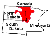
Red River of the North Basin
National Water-Quality Assessment Program
Lorenz, D.L., 1992, Using a Geolographical Information System to Describe the Environmental Setting of the Red River of the North Basin in: Balthrop, B.H., and Baker, E.G., compilers, U.S. Geological Survey
National Computer Technology Meeting -- Program and Abstracts, May 17-22,
1992, Norfolk, VA: U.S. Geological Survey Open-File Report 92-64, p.21
Abstract
A geographic information system was used to describe the environmental setting
of the Red River of the North Basin, one of 20 study units in the U.S.
Geological Survey National Water Quality Assessment Program. Thematic data
used to describe the environmental setting were mean annual precipitation,
mean annual streamflow, surficial and buried aquifers, and ecological regions.
A geographic information system was used to compile these data from various
sources and from various spatial scales, to overlay the themes of data, and to
create map products of the basin. Due to the long-term, in-depth nature of
the the regional water-quality assessment, an early description of the
environmental setting of the study unit is critical for planning the study.
The subsequent multiscale analyses for the water-quality assessment will be facilitated with the geographic information system.
|