Minnesota Water Science Center

RedN NAWQAUSGS IN YOUR STATEUSGS Water Science Centers are located in each state. 
|
Red River of the North BasinNational Water-Quality Assessment ProgramStoner, J.D., Lorenz, D.L., Wiche, G.J., and Goldstein, R.M., 1993, Red River of the North Basin, Minnesota, North Dakota, and South Dakota: American Water Resources Association Monograph Series No. 19 and Water Resources Bulletin, v.29, no.4, pp575-615.
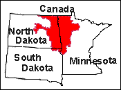
AbstractFrom its origin, the Red River of the North meanders northward for 394 miles to the Canadian border, a path that is nearly double the straight-line distance. The Red River of the North normally receives over 75 percent of its annual flow from the eastern tributaries as a result of regional patterns of precipitation, evapotranspiration, soils, and topography. Most runoff occurs in spring and early summer as a result of rains falling on melting snow or heavy rains falling on saturated soils. Lakes, prairie potholes, and wetlands are abundant in most physiographic areas outside of the Red River Valley Lake Plain. Dams, drainage ditches, and wetlands alter the residence time of water, thereby affecting the amount of sediment, biota, and dissolved constituents carried by the water. Ground water available to wells, streams, and springs primarily comes from sand and gravel aquifers near land surface or buried within 100 to 300 feet of glacial drift that mantles the entire Red River of the North basin. Water moves through the system of bedrock and glacial-drift aquifers in a regional flow system generally toward the Red River of the North and in complex local flow systems controlled by local topography. Many of the bedrock and glacial-drift aquifers are hydraulically connected to streams in the region. The total water use in 1990, about 196 million gallons per day, was mostly for public supply and irrigation. Slightly more than one half of the water used comes from ground-water sources compared to surface-water sources. Most municipalities obtain their water from ground-water sources. However, the largest cities (Fargo, Grand Forks and Moorhead) obtain most of their water from the Red River of the North. The types and relative amounts of various habitats change among the five primary ecological regions within the Red River of the North basin. Headwater tributaries are more diverse and tend to be similar to middle-reach tributaries in character rather than the lower reaches of these tributaries for the Red River of the North. Concentrations of dissolved chemical constituents in surface waters are normally low during spring runoff and after thunderstorms. The Red River of the North generally has a dissolved-solids concentration less than 600 milligrams per liter with mean values ranging from 347 milligrams per liter near the headwaters to 406 milligrams per liter at the Canadian border near Emerson, Manitoba. Calcium and magnesium are the principal cations and bicarbonate is the principal anion along most of the reach of the Red River of the North. Dissolved-solids concentrations generally are lower in the eastern tributaries than in the tributaries draining the western part of the basin. At times of low flow, when water in streams is largely from ground-water seepage, the water quality more reflects the chemistry of the glacial-drift aquifer system. Ground water in the surficial aquifers commonly is a calcium bicarbonate type with dissolved-solids concentration generally between 300 and 700 milligrams per liter. As the ground water moves down gradient, dissolved-solids concentration increases, and magnesium and sulfate are predominant ions. Water in sedimentary bedrock aquifers is predominantly sodium and chloride and is characterized by dissolved-solids concentrations in excess of 1,000 milligrams per liter. Sediment erosion by wind and water can be increased by cultivation practices and by livestock that trample streambanks. Nitrate-nitrogen concentrations also can increase locally in surficial aquifers beneath cropland that is fertilized, particularly where irrigated. Nitrogen and phosphorous in surface runoff from cropland fertilizers and nitrogen from manure can contribute nutrients to lakes, reservoirs, and streams. Some of the more persistent pesticides, such as atrazine, have been detected in the Red River of the North. Few data are available to conclusively define the presence or absence of pesticides and their break-down products in Red River of the North basin aquifers or streams. Urban runoff and treated effluent from municipalities are discharged into streams. These point discharges contain some quantity of organic compounds from storm runoff, turf-applied pesticides, and trace metals. The largest releases of treated-municipal wastes are from the population centers along the Red River of the North and its larger tributaries. Sugar-beet refining, potato processing, poultry and meat packing, and milk, cheese, and cream processing are among the major food processes from which treated wastes are released to streams, mostly in or near the Red River of the North.
Citation Index-Journal Articles | Study Unit Publications | Red River of the North Basin, NAWQA | U.S. Geological Survey in Minnesota | NAWQA Program |