|

ABOUT THE MINNESOTA
WSC
USGS IN YOUR STATE
USGS Water Science Centers are located in each state.

|

Minnesota Water Science Center Newsletter
Summer 2011
|
U.S. Department of Interior
U.S. Geological Survey
Minnesota Water Science Center
2280 Woodale Drive
Mounds View, MN 55112
http://mn.water.usgs.gov
|
|
Spring floods less severe than anticipated
Spring floods were less severe than anticipated at many places in Minnesota. River forecasters at the National Weather Service were concerned that lingering water content from one of the snowiest winters on record in much of Minnesota, combined with spring rains and warm temperatures, could combine to produce record flooding. Fortunately, the snowmelt occurred in relatively distinct phases from south to north across Minnesota. In southern Minnesota snow melted and rivers peaked before areas in northern Minnesota had a chance to melt. Consequently, many rivers in the Mississippi River Basin experienced double flood crests. While these double flood crests prolonged the period of moderate flooding, they tended to be less severe than had both peaks occurred simultaneously.
Monitoring toxic contaminants as part of Great Lakes Restoration Initiative
USGS personnel install monitoring
equipment at the St. Louis River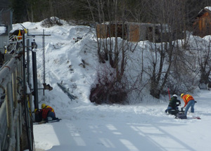 |
The USGS is sampling water for contaminants and monitoring surrogates that may be used to predict loads of contaminant sources as part of the U.S. Environmental Protection Agency's Great Lakes Restoration Initiative (GLRI). Samples were collected for toxic contaminants in bed sediment and lipids (fatty tissue) near streamgages at two Minnesota sites-- the Pigeon River near Grand Portage and the St. Louis River near Scanlon, MN. More recently, an intensive water-quality monitoring station was installed at the St. Louis River near Scanlon. At this site, water samples for analysis of nutrients, suspended sediment, and other constituents, will be collected during runoff. A water-quality monitoring station also was installed for telemetry of continuous turbidity, dissolved oxygen, specific conductance, pH, and water temperature. A combination of these data sources will be used to estimate loads of constituents of concern that flow into Lake Superior. More information can be found on the project's website.
The Sentinel Lakes project is developing tools to assess how changes in water quality affect the availability of deep-water habitat of cold-water fish
Jeff Ziegeweid and Andrew Berg
collecting lake samples.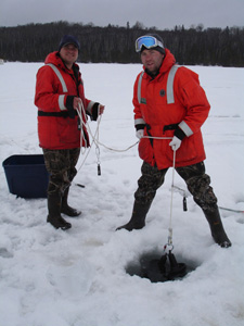 |
The work is being conducted in cooperation with the Minnesota Department of Natural Resources with support from the Minnesota Environment and Natural Resources Trust Fund. Biophysical models of water quality are being developed to predict changes in the optimal habitat for cold-water fish as a function of temperature and dissolved oxygen requirements for the fish species. Data are being collected from three Super Sentinel Lakes as part of a larger effort coordinated by the Minnesota Department of Natural Resources. Nutrients, major ions, and water-quality field properties are being monitored within the lakes, and in the inflows and outflows of the lakes. Continuous water temperature data from multiple depths are being collected to investigate seasonal patterns in thermocline and mixing trends between the lakes. Calibrated lake models can be used to evaluate future management challenges by simulating how optimal fish habitat can be altered by changes in climate and land use. Project chief: Richard Kiesling; Project personnel: Emily Resseger, Sarah Elliott, Jeff Ziegeweid, and Mimi Wallace.
New Scientific Investigation Report
We are pleased to announce the publication of a new Scientific Investigation Report: "Assessment of nutrient enrichment by use of algal, invertebrate, and fish community attributes in wadeable streams in ecoregions surrounding the Great Lakes," by Jeffrey W. Frey, Amanda H. Bell, Julie Hambrook Berkman, and David L. Lorenz. The report is a product of the National Water-Quality Assessment (NAWQA) Program's Major River Basin Assessment (MRB) study of the Great Lakes, Ohio, Upper Mississippi, and Souris-Red-Rainy region. This report highlights the algal, invertebrate, and fish taxa and community attributes that best reflect the effects of nutrients and biological response along a gradient of low to high nutrient concentrations in States surrounding the Great Lakes. An electronic version of this report is available at the pubs warehouse.
The NAWQA website can be referenced for additional information and to access other regional reports of the NAWQA studies.
Even after almost 30 years, research work is still going strong at the National Crude Oil Spill Fate and Natural Attenuation Research Site near Bemidji
Cutting a core at the Bemidji research site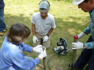 |
The 2011 Request for Proposal (RFP), funded through monies provided by Enbridge Energy to USGS and the Minnesota Pollution Control Agency (MPCA) through the four-party Collaborative Agreement signed in 2009, resulted in award of $29,000 divided among six projects. The projects brought with them more than $77,000 in matching funds for research at the Bemidji site. The Agreement parties are USGS, Enbridge Energy, MPCA, and Beltrami County.
The 2011 field season is scheduled for June 19 - July 1. We expect 30+ researchers to be on-site during the 2-week, USGS-hosted field season, working on several different projects. Project topics include fate and transport of hydrocarbons, biodegradation of high molecular weight hydrocarbons, examination of hydrophobic soil's hydrologic properties, and use of geophysical methods to monitor subsurface changes at a hydrocarbon spill site. Additional information regarding previous work, publications, and ongoing work at the Bemidji site is available.
Missing streamgage
Streamgage Equipment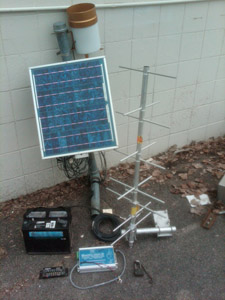 |
On May 5 our field crew found instrumentation removed from our stream gage in Pine County. Missing are a High-Data Rate Data Collection Platform, satellite radio antenna, battery, current regulator, rain gage and solar panels. The theft apparently occurred on Thursday, May 5, between 2015-2030 hours (time of last data logged and transmission). It remains puzzling what someone would do with this equipment. We've filed a sheriff's report with Pine County and if anyone has information, we'd appreciate it. (contact Jim Stark)
Note from the Director - Ensuring Sustainable Water for Minnesota
I had the privilege of attending the Spring Conference of the Minnesota Groundwater Association on May 6. It was an excellent meeting that focused on water sustainability in Minnesota. Subject experts from Minnesota described efforts underway to ensure the sustainability of water for human and ecological needs into the future. This is a much more complex issue than simply making sure that we have enough water for our needs in the near term. Local speakers included Representative Paul Torkelson (MN House of Representatives), Princesa VanBuren Hansen (MN Environmental Quality Board), Dr. Deborah Swackhamer (University of MN Water Resources Center), Jay Frischman and Dr. Jeanette Leete (MN Department of Natural Resources), Lanya Ross (Metropolitan Council) Troy Hall (Moorhead Public Service), and Andrew Streitz (MN Pollution Control Agency). Each of the speakers did a great job.
We also had the opportunity to learn about similar efforts in other states. Those speakers included Linda Hutchins (MA Department of Conservation and Recreation), David Hamilton (MI Department of Environmental Quality) James Cannia (US Geological Survey- Nebraska), and Rod Horn (South Platte Natural Resources District--Nebraska).These states also are addressing this issue and are using approaches and tools that have potential to be applied for efforts in Minnesota. We all benefit from this kind of information exchange and I applaud the Association for taking on this important effort.
|
Sue Langer was selected as the Minnesota Water Science Center's Employee of the Year by her colleagues
Sue Langer |
Sue does an outstanding job maintaining the USGS National Water Information System (NWIS) database for the Center. This work is critical to our scientists and to other Federal and State agencies. Sue ensures that the NWIS database is accurate and accessible. This year, Sue took on extra duties managing the organization and shipping of water samples while continuing to fulfill her normal day-to-day responsibilities. Sue has presented results of special studies at various conferences throughout the year. She represents the Center with integrity and maintains a positive attitude. Sue is a strong advocate for community service and donates personal time and energy to causes that are important to her.
The Minnesota Water Science Center has released two reports that involve chemicals of concern
The first report describes a study of contaminants of concern in wastewater and in streams and lakes that receive wastewater-treatment plant effluent in Minnesota. The study was a cooperative effort among the U.S. Geological Survey, the Minnesota Pollution Control Agency, St. Cloud State University, the University of St. Thomas, and the University of Colorado. The objective of the study was to identify distribution patterns of endocrine active chemicals, pharmaceuticals, and other organic and inorganic chemicals of concern indicative of wastewater effluent, and to identify biological characteristics of estrogenicity and fish responses in the same streams.
The second report summarizes 14 years of research and monitoring of endocrine-active chemicals and biological responses in Minnesota. Endocrine active chemicals have been identified in wastewater-treatment plant effluent and surface waters downstream from discharge of wastewater-treatment plant effluent throughout Minnesota. Although concentrations are typically low, endocrine disruption has been detected in wild fish throughout Minnesota at sites downstream from wastewater-treatment plant effluent. Endocrine active chemicals and endocrine disruption have also been detected at sites with no wastewater effluent discharge. This work has involved St. Cloud State University, Minnesota Department of Health, Minnesota Pollution Control Agency, Minnesota Department of Natural Resources, Metropolitan Council Environmental Services, and the University of Minnesota. Additional information on contaminants of emerging concern is available on our project page.
PAHs increasing in urban U.S. lakes
On April 14, a Congressional briefing featured news from a USGS fact sheet regarding increasing levels of polycyclic aromatic hydrocarbons (PAHs) in urban lakes across the Nation. PAHs are widespread in the environment and are a significant environmental concern because several are probable human carcinogens, they are toxic to fish and other aquatic life, and their concentrations have been increasing in urban lakes in recent decades. Findings show, for example, that coal-tar-based pavement sealant is a much greater source of PAHs to urban lakes than previously identified sources, such as vehicle emissions, used motor oil, and tire particles. The sealants are used on parking lots, driveways, and playgrounds but rarely used on roads. For more information, contact Laura Parsons.
World Water Day, March 22, 2011
Han River Weir in South Korea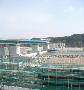 |
On World Water Day, four scientists were invited to speak in at a symposium in Seoul, South Korea on various aspects of water-quality management. Victoria Christensen of the USGS Minnesota Water Science Center was one of those scientists and the following are her observations of the International Symposium for the 19th Anniversary of World Water Day and South Korea.
South Korea, a country about half the size of Minnesota, sits on a peninsula in East Asia. With North Korea as its only neighbor, water surrounds Korea on three sides. Four river systems flow from the central uplands of the peninsula into the seas to the south and east. The Han, Nakdong, Yeongsan, and Geum Rivers are the focus of the massive Four Rivers Restoration Project. Although the project is not without public opposition, Korea's National Institute of Environmental Research has forged ahead with the project, which includes the installation of 16 weirs to provide flood control and water security. Korean scientists are working to integrate a system to manage the water quality, control spill accidents, and ensure water supply for the country. This system includes plans for a national monitoring network of meteorological and hydraulic data, real-time monitoring at nearly 600 sites, and the management of total maximum daily loads (TMDLs). The paper on which I based my presentation, In-Stream Water-Quality Estimation: Case Studies in Real-time Stream and Lake Monitoring in the Central USA, is available from the USGS Minnesota Water Science Center website. Throughout my visit to South Korea, which included field trips to the Four Rivers Visitors Center and a weir construction site, it became clear that Koreans, both in support and in opposition to the project, care deeply about water quality and the environment.
Floods of September 2010 in Southern Minnesota
Severe flooding in Minnesota, 2010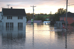 |
During September 22-24, 2010, heavy rainfall ranging from 3 inches to more than 10 inches caused severe flooding across southern Minnesota. The flooding exceeded 500-year and 100-year streamflow events in numerous locations in southern Minnesota. The floods followed wet antecedent conditions, where summer rainfall totals were as high as 20 inches. Flood-peak streamflows during the flooding had annual exceedance probabilities estimated to be less than 0.2 percent (recurrence interval greater than 500 years) at 7 streamgages and less than 1 percent (recurrence interval greater than 100 years) at 5 streamgages.
The USGS, in cooperation with the Federal Emergency Management Agency and the Minnesota Department of Natural Resources, conducted a study to document and summarize the meteorological and hydrologic information pertaining to the floods of September 2010 in southern Minnesota. The widespread flooding that occurred as a result of the heavy rainfall caused evacuations of hundreds of residents, and damages in excess of 64 million dollars to residences, businesses, and infrastructure. In all, 21 counties in southern Minnesota were declared Federal disaster areas.
Peak-of-record streamflows were recorded at nine U.S. Geological Survey and three Minnesota Department of Natural Resources streamgages. The USGS tabulated flood-peak gage heights, peak streamflows, and annual exceedance probabilities for numerous U.S. Geological Survey and Minnesota Department of Natural Resources streamgages to document the magnitude of the flooding.
High-water marks were identified and tabulated for the most severely affected communities of Faribault, Owatonna, Pine Island, and Zumbro Falls. Using these high-water marks, flood-peak inundation maps and water-surface profiles for these four most severely affected communities were constructed. The flood maps and profiles show the extent and height of flooding through the communities and will be used for flood response and recovery efforts by local, county, State, and Federal agencies. A new report summarizes this study.
Red River Sediment report available
A study by the U.S. Geological Survey, in cooperation with the U.S. Army Corps of Engineers was conducted during the 2010 spring high-flow event to determine sediment concentrations, loads, and particle-size distributions at six sites in the Red River of the North and selected tributaries near Fargo, North Dakota. Suspended-sediment (point and integrated samples), bed-material, and bedload samples were collected at the six sites at various time intervals during the high-flow event. Suspended-sediment concentrations in the Red River ranged from 74 to 156 milligrams per liter near Christine, ND and from 81 to 154 milligrams per liter at Fargo. In comparison, the suspended-sediment concentrations ranged from 476 to 1,120 milligrams per liter in the Sheyenne River Streamflow and suspended-sediment concentration data demonstrated that the timing of the peak in suspended-sediment concentration varied in relation to the peak in streamflow among the six sites. The final published report for the 2010 spring sediment sampling is posted online at the pubs warehouse.
|
|
|
