Instant Information Now Available about Minnesota Water Conditions
Now you can receive instant, customized updates about water conditions by subscribing to WaterAlert, a new service from the USGS. Whether you are watching for floods, interested in recreational activities or concerned about the quality of water in your well, WaterAlert allows you to receive daily or hourly updates about current conditions in rivers, lakes and groundwater when they match conditions of concern to you. WaterAlert allows users to receive updates about river flows, groundwater levels, water temperatures, rainfall and water quality at any of more than 9,500 sites where USGS collects real-time water information. This information is crucial for managing water resources, including during floods, droughts and chemical spills. WaterAlert users start at http://water.usgs.gov/wateralert and select a specific site. Users then select the preferred delivery method (email or text), whether they want hourly or daily notifications, which data parameter they are interested in, and the threshold for those parameters. Users can set the system to alert them when conditions are above a value, below a value, and between or outside of a range.
Sign up at http://water.usgs.gov/wateralert.
Spring Flooding Less Severe than Expected
Spring snowmelt floods in Minnesota were generally less severe in 2010 than initially predicted by the National Weather Service (NWS). Floods are compared to the historical flood record by a statistic called the annual recurrence interval or its inverse, the annual exceedance probability (AEP). A new USGS publication explaining these statistics is available. The preferred term is the AEP, in which the smaller the number, the more severe the flood when compared to those on record.
Flooding recorded at USGS streamgages was the most severe in the Minnesota and Red River of the North Basins. Provisional data indicate that streams with the lowest AEPs in Minnesota occurred in the Minnesota River Basin, where 7 streamgages recorded peaks with less than a 4 percent AEP, compared to only one in the Red River Basin. Five streamgages in the Minnesota, 3 in the Red, and 2 in the Upper Mississippi River Basins recorded peaks with AEPs from 4-10 percent.
Although the mild flooding was a relief, USGS staff prepared for the worst prior to flooding by extending stage-discharge rating curves at selected sites for NWS flood prediction modeling, detailing additional USGS personnel from outside Minnesota to make additional flood measurements, meeting with Federal, State, and local agencies to ensure their needs were addressed, and preparing equipment for floods. The most intense flood-related field activities by the USGS occurred during March 14 to 31. More than 240 discharge measurements were made at 147 real-time or crest-stage streamgages. Sediment samples were collected at selected streamgages around the State, with the most collected from streams in Red River Basin. More information is available at http://mn.water.usgs.gov/flood/
Workshop on Understanding Vegetation and Hydrology of Upper Midwest Wetlands, September 22-24
The U.S. Geological Survey (USGS), the Fond du Lac Band of Lake Superior Chippewa and Great Lakes Indian Fish and Wildlife Commission will be holding a 2-day workshop during September 22-24 to demonstrate techniques and tools used to characterize wetland vegetation and hydrology and to assess the effects of land-use and climate change on wetlands. The workshop is supported by the USGS Technical training in Support of Native American Relations (TESNAR) Program. Scientists from government agencies, universities, and private companies will present information and research results on specific wetland issues to tribal resource managers and tribal members who require knowledge about wetland hydrology and wetland ecology. Topics will include wetland water budgets, water chemistry, groundwater/surface-water interactions, nutrient dynamics, effects of climate change, hydrologic effects on wetland ecology, and mining effects on wetlands. This workshop will provide valuable information needed to assess the vulnerability of ecosystems and reduce wetland losses resulting from adverse changes to the landscape. For more information, contact Perry M. Jones.
StreamStats Online for Minnesota
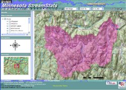 StreamStats for Minnesota is a Web-based Geographic Information System that provides users with access to an assortment of analytical tools that are useful for water-resources planning and management, and for engineering design applications, such as the design and sizing of bridges. StreamStats allows users to easily obtain streamflow statistics, drainage-basin characteristics, and other information for user-selected sites on streams. StreamStats users can choose locations of interest from an interactive map and obtain information for these locations. If a user selects the location of a U.S. Geological Survey (USGS) data-collection station, the user will be provided with a list of previously published information for the station. If a user selects a location where no data are available (an ungaged site), StreamStats will delineate the drainage-basin boundary, measure basin characteristics and output a table with the 1.5, 2, 5, 10, 25, 50, 100, and 500 year peak streamflow estimates for the site. The peak streamflow estimates are based on regression equations from the USGS Scientific Investigations Report "Techniques for Estimating the Magnitude and Frequency of Peak Flows on Small Streams in Minnesota Based on Data through Water Year 2005" Scientific Investigations Report 2009-5250.
Endocrine Active Chemicals and Endocrine Disruption In Minnesota
Several studies have been completed in cooperation with the St. Cloud State University, Minnesota Department of Health, Minnesota Pollution Control Agency, Minnesota Department of Natural Resources, Metropolitan Council Environmental Services, and the University of Minnesota to determine the presence of endocrine active chemicals and the incidence of endocrine disruption in Minnesota streams and lakes since 1994.
Results from a series of studies demonstrate that endocrine active chemicals are present in Minnesota surface waters, indicating that aquatic organism exposure is likely. Endocrine active chemicals have been identified in wastewater-treatment plant effluent and surface waters downstream from discharge of wastewater-treatment plant effluent throughout Minnesota at low concentrations. Biological indicators of endocrine disruption have been detected in wild fish throughout Minnesota at sites directly downstream from wastewater-treatment plant effluent, indicating that endocrine active chemicals in effluent contribute to endocrine disruption in fish. This finding was confirmed in a controlled study exposing fathead minnows to wastewater-treatment plant effluent at an onsite fish exposure laboratory. Although chemicals contributing to endocrine disruption in fish are complex, several laboratory studies have further confirmed that certain classes of chemicals, such as hormones and alkylphenols, which are components of wastewater-treatment plant effluent, affect the endocrine systems of fish through biochemical, structural, and behavioral disruption. Although these studies indicate that wastewater-treatment plant effluent is a conduit for endocrine active chemicals to surface waters, endocrine active chemicals also were present in surface waters with no obvious wastewater-treatment plant effluent sources. These observations indicate that other unidentified sources of endocrine active chemicals exist, such as runoff from land surfaces, atmospheric deposition, inputs from onsite septic systems, or other groundwater sources. The presence of biological indicators of endocrine disruption in male fish indicates that the fish are exposed to endocrine active chemicals. However their presence in male fish does not indicate an effect on fish reproduction or changes in fish populations. More information is available at the project website.
Research Continues at the National Crude Oil Spill Fate and Natural Attenuation Site
For more than 25 years the long-term fate of hydrocarbons in the subsurface has been investigated by a multi-disciplinary group of scientists at the Bemidji research site. In 2010, additional research support was awarded to six new projects through a Request for Proposals (RFP) process. Support for this RFP is part of a 2009 Collaborative Agreement between Enbridge Energy, Beltrami County, the Minnesota Pollution Control Agency, and USGS. Successful or awarded proposals were announced in early May for work beginning in summer 2010. The new, proposed work brings new researchers to the site from academic institutions in California, Oklahoma, Colorado, and New Jersey. One new industry researcher will also begin work at the site, with additional financial support from the American Petroleum Institute. Researchers from the University of St. Thomas, Bemidji State University, USGS National Research Program and the Office of Groundwater, Branch of Geophysics, will also be continuing past projects or beginning new work. For more information contact Mindy Erickson or view the Project Website.
Minnesota Department of Health and Minnesota Water Science Center Cooperate on Project to Assess Regional Differences in Arsenic Concentrations in Minnesota Groundwater
Naturally occurring arsenic is common in groundwater in Minnesota. Drinking-water managers need to know where high arsenic in groundwater is likely to occur before issuing well regulations, or permitting or investing in new production wells. Statewide arsenic results show that arsenic concentrations in Minnesota groundwater are higher in the western part of the state; however, elevated arsenic concentrations have been found in groundwater statewide, and arsenic concentrations have significant spatial variability. In cooperation with the Minnesota Department of Health (MDH), the U.S. Geological Survey is beginning a project to assess two-dimensional spatial distribution of high arsenic groundwater in three counties of the state. Phase I of this study has two specific objectives: assess the two- and three-dimensional spatial distribution of arsenic in groundwater in Anoka County, Carlton County, and Ottertail County, Minnesota, and identify data needs for developing a predictive model for high arsenic concentrations in groundwater. This investigation is now possible because of large amounts of new groundwater arsenic concentration data being collected by the MDH and recently completed geologic and hydrogeologic mapping completed by the Minnesota Geological Survey (MGS) and the Minnesota Department of Natural Resources (MDNR).
|
Report Released: "Evaluation of Methods for Delineating Zones of Transport for Production Wells in Karst and Fractured-Rock Aquifers of Minnesota"
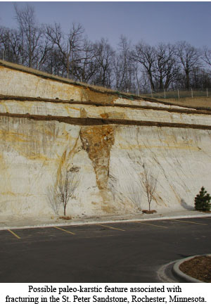 The U.S. Geological Survey (USGS) Minnesota Water Science Center in cooperation with the Minnesota Department of Health has completed a report on a study to evaluate methods for delineating zones of groundwater transport for production wells in karst and fractured-rock aquifers in Minnesota. About 78 percent of Minnesotans use groundwater extracted from bedrock and glacial aquifers for their drinking water. Protection of these well-water supplies is difficult for communities that extract water from bedrock aquifers in which groundwater flows mainly through karst features (solution openings and solution channels or conduits) and fractures. Assessment of groundwater-flow conditions in the vicinity of production wells in karst and fractured-rock settings commonly is difficult due in part to the lack of detailed hydrogeologic information and the resources needed to collect it. Methods for delineating zones of groundwater transport around wells were applied to the 24 production wells that extract groundwater from karst and fractured-rock aquifers in nine Minnesota communities. Zones of transport delineated using these two empirical methods were compared with zones of transport previously delineated by Minnesota Department of Health hydrologists for the wells. The report can be accessed at the Publication Warehouse. For more information, contact Perry M. Jones.
Low-Flow Characterization of the Mississippi River
A study was completed to characterize low-flows in the Mississippi River above Anoka (MRA). The study, in cooperation with the Metropolitan Council assessed the risk of drought on water supplies for the Twin Cities Metropolitan Area. The likelihood of extremely low flow was estimated by a superposition method; 5776 synthetic flows were computed resulting in a minimum synthetic lowflow of 398 cubic feet per second at a probability of occurrence of 0.0002 per year. Low-flow conditions at the MRA, defined as flow less than the tenth percentile of flow, were associated with low-flow conditions at two or fewer of four upstream sites 42 percent of the time, indicating that for many lowflows there is sufficient water in the basin and the threat of extremely low flows is low. But summer low-flow conditions at the MRA were almost always associated with low water levels in three or more of the six headwaters reservoirs.
Results are presented in Lorenz, D.L. and Kessler, E.W., 2009, Low-flow characteristics of the Mississippi River and selected tributaries: Final Program and Book of Abstracts Minnesota Water Resources Conference October 26-27, 2009, St. Paul, Minn.
Report Released on Estimates of Peak Streamflows
Estimates of peak-flow magnitudes for 1.5-, 2-, 5-, 10-, 25-, 50-, 100-, and 500-year recurrence intervals are presented for streamflow stations in Minnesota, based on data through water year 2005. The peak-flow frequency information was subsequently used in regression analyses to develop equations relating peak flows for selected recurrence intervals to various basin and climatic characteristics. Regional regression equations were developed for selected recurrence intervals in each of six regions in Minnesota. The regression equations can be used to estimate peak flows at ungaged sites not affected by urbanization.
The Report is Techniques for Estimating the Magnitude and Frequency of Peak Flows on Small Streams in Minnesota Based on Data through Water Year 2005(SIR 2009-5250) by David L. Lorenz, Chris A. Sanocki, and Matthew J. Kocian
USGS Data Series Report DS 495 "Perchlorate Data for Streams and Groundwater in Selected Areas of the United States, 2004" is Now Available Online
This report presents data collected as part of a reconnaissance study to evaluate the occurrence of perchlorate in rivers and streams and in shallow aquifers in selected areas of the United States. Perchlorate, a component in rocket fuels, fireworks, and some explosives is soluble in water and persists in soils and water for long periods. It is biologically active at relatively low levels in the environment, and has been identified as an endocrine-disrupting chemical. The purpose of this reconnaissance was to determine the occurrence of perchlorate in agricultural areas of the Midwestern and North-Central United States and in arid Central and Western parts of the United States.
Samples were collected from 171 sites on rivers and streams and 146 sites from wells during the summer and early fall of 2004. Samples were collected from surface-water sites in 19 states and from wells in 5 States. Perchlorate was detected in samples collected in 15 States and was detected in 34 of 182 samples from rivers and streams and in 64 of 148 groundwater samples at concentrations equal to or greater than 0.4 micrograms per liter. Perchlorate concentrations were 1.0 micrograms per liter or greater in surface-water samples from 7 States and in groundwater samples in 4 states. Only one surface-water and one groundwater sample had concentrations greater than 5.0 micrograms per liter. Perchlorate concentrations in followup samples collected from 1 to 3 months after the initial sample were unchanged at 4 of 5 stream sites.
Report released on Midwest floods of 2008
During 2008, record precipitation amounts, coupled with already saturated soils, resulted in flooding along many rivers in the United States Midwest. Separate flooding events occurred in January, February, March, April, May, June, July, and September of 2008. The June floods were by far the most severe and widespread with substantial (and in places record) flooding and damage occurring in Illinois, Indiana, Iowa, Kansas, Michigan, Minnesota, Missouri, Nebraska, Oklahoma, South Dakota, and Wisconsin. Indiana had the most recurrent flooding during 2008, with peak-of-record streamflows occurring during January, February, March, June, and September. During 2008, peak-of-record streamflows were recorded at more than 147 U.S. Geological Survey (USGS) streamgages. The annual exceedance probability of the peak streamflows at 25 streamgages was less than 0.2 percent and between 0.2 and 1 percent at 68 streamgages. Trends in flood magnitudes were computed for USGS Midwest streamgages that had no regulation. No Midwest-wide systematic trends upward or downward were evident, although clusters of consistent trends (both upward and downward) were detected in parts of the Midwest.
The report is Flooding in the United States Midwest, 2008 by Robert R. Holmes, Todd A Korning, and Krista A Karstensen, U. S. Geological Survey Professional Paper 1775
Water-Budget Changes from Precipitation Variability at the Glacial Ridge National Wildlife Refuge
Surface waters and surficial groundwaters form an integrated dynamic hydrologic system at the Glacial Ridge National Wildlife Refuge near Crookston, in northwestern Minnesota. The U.S. Geological Survey measured or estimated the amount of water flowing through each part of this system during 2003-5. Results indicate that the hydrologic system responded very quickly (within a year) to the total amount of precipitation. The differences in precipitation between years caused changes in flow between surface waters and groundwater with groundwater flows buffering surface-water flows. During a year of near-normal precipitation (2005), 53 percent (%) of the water that fell in the area was returned to the atmosphere as evapotranspiration, 37% recharged groundwater, and 10% of precipitation ran off to ditches. That same year, surface water flow through channels was about 25% of precipitation and was composed of 39% groundwater discharge and 61% direct runoff.
Save the Date: National Research Lectures at the USGS Minnesota Water Science Center
September 27, 2010: We are fortunate to have two guest lectures at the Minnesota Water Science Center on September 27. Please save the dates. Details will follow.
- Dr. Nancy Simon, USGS, Reston Virginia--Sediments as a source and sink for phosphorus - internal loading versus retention of nutrients
- Dr. Marie Noele Croteau, USGS National Research Program, Menlo Park, California-- Assessing bioavailability and toxicity of engineered metallo-nanoparticles in aquatic environments using enriched stable isotope tracers and biodynamic modeling
Minnesota Water Sustainability Framework
In April I had the opportunity to participate in a team effort to provide input about water sustainability and ecosystem services as part of the University of Minnesota's Framework effort to provide the legislature with guidance about sustainable waters. Having participated in several efforts to guide groundwater sustainability planning for state, I came to the meeting thinking that the most important aspect for maintaining aquatic ecological services was to maintain groundwater flow to streams during low flow. I left the meeting with a better understanding of the complex interrelationships that affect aquatic ecological services. I also learned that physical hydrologists and ecologists need to work together but speak different languages. The process continues. Physical hydrologists and aquatic ecologists need to continue the dialog.
Jim Stark
|


