|

ABOUT THE MINNESOTA
WSC
USGS IN YOUR STATE
USGS Water Science Centers are located in each state.

|

Minnesota Water Science Center Newsletter
Spring 2011
|
U.S. Department of Interior
U.S. Geological Survey
Minnesota Water Science Center
2280 Woodale Drive
Mounds View, MN 55112
http://mn.water.usgs.gov
|
 |
|
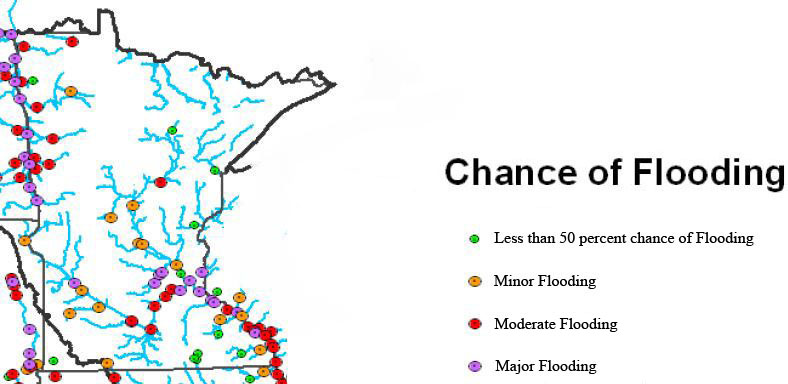
Spring Flood Outlook in Minnesota
The threat of widespread, major flooding in Minnesota and other areas of the Upper Midwest this spring is great. A recent multi-agency meeting to discuss the threat indicated that major to peak-of-record flooding has about a 20-percent chance of occurrence in the Red, Mississippi, and Minnesota River Basins. Even the Mississippi River at St. Paul has about a 15-percent risk of exceeding the previous peak of record stage at 26.01 feet. The dots on the map show the likelihood of major flooding (courtesy of the National Weather Service).
Several factors contribute to the likelihood of major floods. Precipitation in late summer and early fall was much above average. Late-season precipitation saturated the soil and recharged aquifers so that streamflow remains greater than average. Precipitation in the early winter also was much above average throughout all of Minnesota. Precipitation in the winter tends to remain on the soil as snow, which can be released quickly during the spring thaw. Recent estimates indicate that much of Minnesota is covered by more than 4 inches of snow-water equivalent, the equivalent of a 4-inch rain storm.
Scientist Spotlight - Victoria Christensen
 Victoria Christensen has been invited to be a main speaker for the 19th International World Water Day in Seoul, South Korea on March 21, 2011. The theme of this symposium is "Prediction and Monitoring for Operational Water Quality Management in River Systems". The symposium event is being organized by the South Korean government (Ministry of Environment). Vicki will present a paper on "In-stream water-quality estimation: case studies in continuous, real-time monitoring".
Vicki received her B.A. from Hamline University and B.S. and M.S. degrees from the University of Kansas. Her master's research examined the occurrence and fate of dissolved solids, nutrients, atrazine, and bacteria in an agricultural watershed. She joined the USGS Kansas Water Science Center in 1992 and the USGS Minnesota Water Science Center in 2002. Her interests and project work include real-time water-quality monitoring, effects of land use on water quality, the fate of nutrients in agricultural and reservoir systems, and reservoir sediment studies. She also has an interest in communicating science topics to broad audiences in order to share her appreciation of the natural environment.
New report released on water availability in the Great Lakes Basin
 Although the Great Lakes are the largest freshwater system on Earth, the basin has the potential for local shortages, according to a new basin-wide water availability assessment by the USGS. Water availability in the Great Lakes Basin is a balance between storage of surface water and groundwater in the system, flows of water through the system, and existing, sometimes competing, human and ecological uses of water. Water use has a relatively minor effect on regional water availability, because of the large volume of water in storage, large annual flows, and abundant, high-quality groundwater. Development in the Great Lakes region also has had relatively little effect on basin-wide water availability, although surface-water diversions and pumping of groundwater have affected some flow patterns over large areas of the basin.
This study and related groundwater availability studies being conducted nationally by the USGS through the Groundwater Resources Program support the proposed Water Census for the United States. The Water Census is an initiative to provide citizens, communities, natural-resource managers, and policymakers with a clear knowledge of the status of their water resources, data on trends in water availability and use over recent decades, and an improved ability to forecast the availability of freshwater for future human, economic, and environmental uses. Reports from this study, as well as additional information on USGS water availability studies in the Great Lakes Basin, are available online.
New Report released
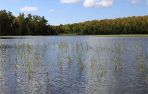 We are pleased to announce a new publication on nutrient conditions for two lakes on the Grand Portage Reservation in northeastern Minnesota. The USGS cooperated with the Science Museum of Minnesota and the Grand Portage Band of Chippewa Indians to study Swamp and Speckled Trout Lakes. Water samples and sediment cores were used to establish reference nutrient conditions. Results from this study may be used as a guide in establishing nutrient criteria in these and other lakes on the Grand Portage Reservation. For more information, contact Victoria Christensen.
Christensen, V.G., Jones, P.M., Edlund, M.B., and Ramstack, J.M., 2010, Water quality (2000-08) and historical phosphorus concentrations from paleolimnological studies of Swamp and Speckled Trout Lakes, Grand Portage Reservation, northeastern Minnesota: U.S. Geological Survey Scientific Investigations Report 2010-5192, 53 p.
Explaining mercury in selected watersheds across the Nation
New studies build an understanding of how natural features and human activities affect the transformation, transport, and bioaccumulation of mercury in stream ecosystems.
- Hydrological mobilization of mercury and dissolved organic carbon in a snow-dominated, forested watershed - conceptualization and modeling, by Schelker and others in the Journal of Geophysical Research (vol. 116, G01002). (USGS Contact: Doug Burns, phone: 518-285-5662). Available for free download via Author Choice.
- Flood hydrology and methylmercury availability in Coastal Plain rivers: by Bradley and others, in the journal, Environmental Science and Technology (v. 44, p. 9285-9290). Available for free download via Author Choice. (USGS Contact: Paul Bradley, phone: 803-750-6125)
- Simulation of streamflow in the McTier Creek watershed, South Carolina: by Feaster and others, in U.S. Geological Survey Scientific Investigations Report 2010-5202. (USGS contact: Toby Feaster, phone: 803-750-6103)
- Total mercury, methylmercury, and selected elements in soils of the Fishing Brook watershed, Hamilton County, New York, and the McTier Creek watershed, Aiken County, South Carolina, 2008: by Woodruff and others, in U.S. Geological Survey Data Series 516. (USGS contact: Laurel Woodruff, 763-783-3291)
|
USGS Staff Prepare for Flooding
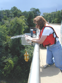
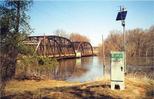
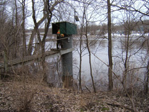 U.S. Geological Survey (USGS) staff are preparing for possible widespread and major flooding this spring as forecast by the National Weather Service (NWS). Substantial flooding is expected because above-normal precipitation last fall has caused streams to flow at 100 to 1,000 percent of normal this winter. In addition, snowfall has been greater than normal. USGS preparations include flood "hardening" streamgages, arranging for "rapid-deployment streamgages" that can be installed if existing streamgages become inoperable, requesting additional staff from other USGS offices nationwide to help make flood measurements, extending stage-discharge rating curves and preparing winter flow-duration analyses for sites requested by the National Weather Service, and coordinating with other Federal, State, and local agencies for specific flood information needs.
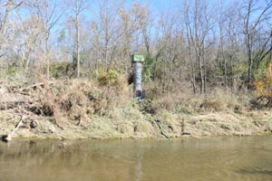 Streamgages are flood-hardened differently, depending on the existing installation and the forecasted level of flood crests. In the simplest case, instrumentation and power may be elevated within the existing gage house. For more vulnerable streamgages, a redundant set of water-level recorders and telemetry may be temporarily or permanently installed at a higher elevation.
Rapid-deployment streamgages are lightweight, turnkey-ready USGS streamgages that can be shipped overnight and installed quickly on bridges. A limited number exist for use nationwide during floods, so installations are for emergency purposes only.
More information...
USGS Exhibit at Mall of America
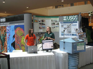 Every winter for the last 10 years, the Minnesota Federal Executive Board has sponsored an event with the Mall of America called the Government on Display Expo. This year, during the weekend of January 29-30, 2011, the U.S. Geological Survey (USGS) provided an exhibit that highlights programs and activities of the agency. The exhibit included a streamgage model, posters, and USGS publications and brochures. The USGS Earth Resources Observation and Science (EROS) Center provided a display featuring products from the USGS Image Gallery. Several USGS employees volunteered their time to talk with the public and provide information about the USGS.
Fact Sheet on USGS Sampling Protocols
A fact sheet and a video are now available that summarize water-quality sampling procedures used by staff of the USGS. The video shows USGS sampling procedures along the northern coast of the Gulf of Mexico in response to the Deepwater Horizon oil spill.
Fact Sheet 2010-3121: "Water-Quality Sampling by the U.S. Geological Survey: Standard Protocols and Procedures."
Coal-tar sealant largest source of polycyclic aromatic hydrocarbons (PAHs) in urban lakes
The presence of PAHs in the environment is widespread, and USGS research has recently demonstrated that coal-tar-based pavement sealants are the largest sources of PAHs to urban lakes. Sealcoat products are widely used in the United States, both commercially and by homeowners. The products are commonly applied to commercial parking lots (including strip malls, schools, churches, and shopping centers), residential driveways, apartment complexes, and playgrounds. PAHs are an environmental health concern because several are probable human carcinogens, they are toxic to fish and other aquatic life, and their concentrations have been increasing in urban lakes in recent decades.
Access the full report in the journal Science of the Total Environment and the USGS press release (December 1, 2010). For information on the study, contact Barb Mahler, (512) 927-3566. Learn more about other contaminants in lake sediments.
Altered flows lead to ecological degradation in streams across the United States
Most river flows across the United States are altered by land- and water-management activities (such as related to reservoirs, diversions, subsurface tile drains, groundwater withdrawals, wastewater inputs, and impervious surfaces), leading to ecological degradation and loss of native species. USGS findings show that the amount of water flowing in streams and rivers has been significantly altered in nearly 90 percent of waters that were assessed across the Nation. Altered river flows lead to the loss of native fish and invertebrate species whose survival and reproduction are tightly linked to specific flow conditions. For example, in streams with severely diminished flow, native trout, a popular sport fish that requires fast-flowing streams with gravel bottoms, are replaced by less desirable non-native species, such as carp.
Access the full study, published in the Ecological Society of America journal Frontiers in Ecology and the Environment and the USGS press release. For more information on the study, contact Daren Carlisle, (703) 648-6890. Learn more about other national ecology studies.
Models help to estimate nitrate concentrations in private wells in the glacial aquifer system in the United States
An estimated 17 million people use private wells that tap the glacial aquifer system. USGS glacial studies include modeled estimates on the probability of nitrate concentration above various thresholds. Modeled findings demonstrated significant predictors for nitrate concentration greater than 4 milligrams per liter as nitrogen, including well characteristics such as open-interval diameter, open-interval length, and depth to top of open interval.
Access the USGS report (and other information on the glacial aquifer system) online. For more information on the glacial studies, contact Kelly Warner, 217-328-9739, ext. 9727.
|
|
|
