USGS - science for a changing world

Minnesota Water Science Center

  Home   Information/Data   Projects   Publications   Drought   Flood   NAWQA   Office   Contact   Other USGS

Emerging Contaminant and Endocrine Studies

Minnesota PROJECTS

USGS IN YOUR STATE

USGS Water Science Centers are located in each state.

There is a USGS Water Science Center office in each State. Washington Oregon California Idaho Nevada Montana Wyoming Utah Colorado Arizona New Mexico North Dakota South Dakota Nebraska Kansas Oklahoma Texas Minnesota Iowa Missouri Arkansas Louisiana Wisconsin Illinois Mississippi Michigan Indiana Ohio Kentucky Tennessee Alabama Pennsylvania West Virginia Georgia Florida Caribbean Alaska Hawaii New York Vermont New Hampshire Maine Massachusetts South Carolina North Carolina Rhode Island Virginia Connecticut New Jersey Maryland-Delaware-D.C.

Fate and Effects of Alkylphenols and other Endocrine Active Chemicals in Three Minnesota Streams

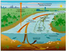
The U.S. Geological Survey (USGS), the Minnesota Pollution Control Agency, and St. Cloud State University conducted an integrated chemical and biological study of three streams (South Fork Crow River, Redwood River, and Grindstone River) that receive wastewater in Minnesota. The objective of the study was to identify distribution patterns of endocrine-active chemicals and other organic chemicals indicative of wastewater, and to identify fish responses in the same streams. Endocrine-active chemicals are a class of chemicals that interfere with the natural regulation of endocrine systems, and an understanding of their distribution in aquatic systems is important so that aquatic organism exposure can be evaluated.

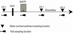
The USGS collected and analyzed water and quality-assurance samples and measured streamflow during six sampling events in each of three streams. Water samples were collected upstream from and at two successive points downstream from wastewater-treatment plant (WWTP) effluent discharge and from treated effluent from February through September 2007.

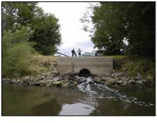
Bed sediment samples were collected during one sampling period at each of the stream locations. Water and bed-sediment samples were analyzed for endocrine-active chemicals including alkylphenols, alkylphenol polyethoxylates, and nonylphenol ethoxycarboxlylates (NPECs). Water samples were also analyzed for major ions, nutrients, and organic carbon. In addition, as part of an intensive time-series investigation, the USGS staff collected daily samples for 8 weeks from the Redwood River near Marshall, Minn., for analyses of total alkylphenols and atrazine. St. Cloud State University staff collected and analyzed fish to determine male fish responses at all water sampling sites and at an additional site near the wastewater-treatment plant effluent discharge to these streams. Male fish responses included the presence and concentration of vitellogenin in plasma, gonadosomatic indices, and histological characterizations of liver and testes tissue.

Lee, K.E., Schoenfuss, H.L., Jahns, N.D., Brown, G.K., and Barber, L.B., 2008, Alkylphenols, other endocrine-active chemicals, and fish responses in three streams in Minnesota—Study design and data, February–September 2007: U.S. Geological Survey Data Series 405, 44 p. plus appendixes.
http://pubs.usgs.gov/ds/405/

USGS Home Water Resources Biology Geography Geology Geospatial

Accessibility FOIA Privacy Policies and Notices

Take Pride in America logo USA.gov logo U.S. Department of the Interior | U.S. Geological Survey
URL: http://mn.water.usgs.gov/projects/CED/alkyl.html
Page Contact Information: Webmaster
Page Last Modified: Friday, 09-Jan-2009 10:57:24 EST

05301000: Flow=2070cfs,Stage=27.37ft,2009-11-27 04:00,High,MINNESOTA RIVER NEAR LAC QUI PARLE, MN 05300000: Flow=254cfs,Stage=6.79ft,2009-11-27 04:00,High,LAC QUI PARLE RIVER NEAR LAC QUI PARLE, MN 05054000: Flow=2310cfs,Stage=16.32ft,Floodstage=18.0ft,2009-11-27 04:15,High,RED RIVER OF THE NORTH AT FARGO, ND 05053000: Flow=352cfs,Stage=2.53ft,Floodstage=10.0ft,2009-11-27 04:15,High,WILD RICE RIVER NR ABERCROMBIE, ND 05051500: Flow=1530cfs,Stage=7.18ft,Floodstage=10.0ft,2009-11-27 04:00,High,RED RIVER OF THE NORTH AT WAHPETON, ND 05330000: Flow=5960cfs,Stage=10.56ft,Floodstage=25.0ft,2009-11-27 04:00,>90,MINNESOTA RIVER NEAR JORDAN, MN 05325000: Flow=5870cfs,Stage=6.93ft,Floodstage=22.0ft,2009-11-27 04:00,>90,MINNESOTA RIVER AT MANKATO, MN 05320000: Flow=1560cfs,Stage=3.76ft,2009-11-27 04:15,>90,BLUE EARTH RIVER NEAR RAPIDAN, MN 05313500: Flow=118cfs,Stage=3.01ft,2009-11-27 03:00,>90,YELLOW MEDICINE RIVER NEAR GRANITE FALLS, MN 05311000: Flow=2510cfs,Stage=9.23ft,Floodstage=14.0ft,2009-11-27 04:00,>90,MINNESOTA RIVER AT MONTEVIDEO, MN 05294000: Flow=232cfs,Stage=5.45ft,2009-11-27 04:00,>90,POMME DE TERRE RIVER AT APPLETON, MN 05293000: Flow=93cfs,Stage=2.63ft,2009-11-27 04:00,>90,YELLOW BANK RIVER NEAR ODESSA, MN 05291000: Flow=121cfs,Stage=2.56ft,2009-11-27 04:00,>90,WHETSTONE RIVER NEAR BIG STONE CITY, SD 05290000: Flow=129cfs,Stage=11.14ft,Floodstage=17.0ft,2009-11-27 04:45,>90,LITTLE MINNESOTA RIVER NEAR PEEVER, SD 05280000: Flow=1080cfs,Stage=3.54ft,Floodstage=10.0ft,2009-11-27 04:00,>90,CROW RIVER AT ROCKFORD, MN 05270500: Flow=391cfs,Stage=2.19ft,Floodstage=6.0ft,2009-11-27 03:00,>90,SAUK RIVER NEAR ST. CLOUD, MN 05247500: Flow=2040cfs,2009-11-27 04:30,Stage=4.53ft,2009-11-27 03:30:00,>90,CROW WING RIVER NEAR PILLAGER, MN 05094000: Flow=39cfs,Stage=3.78ft,2009-11-27 04:00,>90,SOUTH BRANCH TWO RIVERS AT LAKE BRONSON, MN 05092000: Flow=5200cfs,Stage=13.75ft,Floodstage=32.0ft,2009-11-27 04:00,>90,RED RIVER OF THE NORTH AT DRAYTON, ND 05082500: Flow=5000cfs,Stage=17.83ft,Floodstage=28.0ft,2009-11-27 04:30,>90,RED RIVER OF THE NORTH AT GRAND FORKS, ND 05064500: Flow=3660cfs,Stage=9.99ft,Floodstage=26.0ft,2009-11-27 04:00,>90,RED RIVER OF THE NORTH AT HALSTAD, MN 05064000: Flow=607cfs,Stage=7.96ft,Floodstage=20.0ft,2009-11-27 03:00,>90,WILD RICE RIVER AT HENDRUM, MN 05062500: Flow=337cfs,Stage=3.41ft,Floodstage=10.0ft,2009-11-27 02:00,>90,WILD RICE RIVER AT TWIN VALLEY, MN 05062000: Flow=343cfs,Stage=7.32ft,Floodstage=12.0ft,2009-11-27 04:30,>90,BUFFALO RIVER NEAR DILWORTH, MN 05061500: Flow=156cfs,2009-11-27 03:00,Stage=8.62ft,2009-11-26 21:00:00,Floodstage=12.0ft,>90,SOUTH BRANCH BUFFALO RIVER AT SABIN, MN 05061000: Flow=138cfs,2009-11-27 01:30,Stage=4.45ft,2009-11-27 03:15:00,Floodstage=7.0ft,>90,BUFFALO RIVER NEAR HAWLEY, MN 05046000: Flow=822cfs,Stage=3.59ft,2009-11-27 04:00,>90,OTTER TAIL RIVER BL ORWELL D NR FERGUS FALLS, MN 06482610: Flow=73cfs,Stage=2.35ft,Floodstage=8.5ft,2009-11-27 04:45,76-90,SPLIT ROCK CR AT CORSON,SD 05457000: Flow=179cfs,Stage=3.05ft,2009-11-27 04:00,76-90,CEDAR RIVER NEAR AUSTIN, MN 05327000: Flow=74cfs,Stage=3.42ft,2009-11-27 01:30,76-90,HIGH ISLAND CREEK NEAR HENDERSON, MN 05320500: Flow=590cfs,Stage=2.58ft,2009-11-27 01:00,76-90,LE SUEUR RIVER NEAR RAPIDAN, MN 05317200: Flow=77cfs,Stage=3.85ft,2009-11-27 03:00,76-90,LITTLE COTTONWOOD RIVER NEAR COURTLAND, MN 05317000: Flow=270cfs,Stage=3.79ft,Floodstage=11ft,2009-11-27 04:00,76-90,COTTONWOOD RIVER NEAR NEW ULM, MN 05316500: Flow=135cfs,Stage=2.37ft,Floodstage=6.0ft,2009-11-27 02:00,76-90,REDWOOD RIVER NEAR REDWOOD FALLS, MN 05304500: Flow=399cfs,Stage=2.12ft,2009-11-27 04:00,76-90,CHIPPEWA RIVER NEAR MILAN, MN 05288500: Flow=8430cfs,Stage=3.97ft,2009-11-27 04:00,76-90,MISSISSIPPI RIVER NEAR ANOKA, MN 05267000: Flow=5660cfs,Stage=10.07ft,2009-11-27 04:00,76-90,MISSISSIPPI RIVER NEAR ROYALTON, MN 05245100: Flow=150cfs,Stage=2.33ft,Floodstage=6.0ft,2009-11-27 04:00,76-90,LONG PRAIRIE RIVER AT LONG PRAIRIE, MN 05244000: Flow=593cfs,Stage=3.34ft,2009-11-27 03:00,76-90,CROW WING RIVER AT NIMROD, MN 05131500: Flow=1060cfs,Stage=4.20ft,2009-11-27 04:30,76-90,LITTLE FORK RIVER AT LITTLEFORK, MN 05130500: Flow=108cfs,Stage=2.46ft,2009-11-27 04:30,76-90,STURGEON RIVER NEAR CHISHOLM, MN 05078500: Flow=158cfs,Stage=2.47ft,2009-11-27 04:00,76-90,CLEARWATER RIVER AT RED LAKE FALLS, MN 05076000: Flow=128cfs,Stage=5.33ft,2009-11-27 04:15,76-90,THIEF RIVER NEAR THIEF RIVER FALLS, MN 05069000: Flow=46cfs,Stage=4.64ft,Floodstage=20.0ft,2009-11-27 02:00,76-90,SAND HILL RIVER AT CLIMAX, MN 05067500: Flow=10cfs,Stage=4.36ft,Floodstage=14.0ft,2009-11-27 04:15,76-90,MARSH RIVER NEAR SHELLY, MN 05124480: Flow=30cfs,Stage=2.73ft,2009-11-27 04:00,10-24,KAWISHIWI RIVER NEAR ELY, MN 05388250: Flow=452cfs,Stage=7.73ft,Floodstage=14.0ft,2009-11-27 04:00,25-75,Upper Iowa River near Dorchester, IA 05355200: Flow=453cfs,Stage=3.52ft,2009-11-27 04:00,25-75,CANNON RIVER AT WELCH, MN 05353800: Flow=106cfs,Stage=4.15ft,2009-11-27 00:00,25-75,STRAIGHT RIVER NEAR FARIBAULT, MN 05345000: Flow=39cfs,Stage=2.62ft,2009-11-27 01:30,25-75,VERMILLION RIVER NEAR EMPIRE, MN 05338500: Flow=396cfs,2009-11-27 02:00,0000-00-00 00:00:00,Floodstage=9.0ft,25-75,SNAKE RIVER NEAR PINE CITY, MN 05336700: Flow=481cfs,Stage=4.90ft,2009-11-27 02:00,25-75,KETTLE RIVER BELOW SANDSTONE, MN 05336000: Flow=2090cfs,Stage=4.60ft,2009-11-27 04:00,25-75,ST. CROIX RIVER NEAR GRANTSBURG, WI 05319500: Flow=230cfs,Stage=1.67ft,2009-11-27 02:00,25-75,WATONWAN RIVER NEAR GARDEN CITY, MN 05286000: Flow=410cfs,Stage=2.84ft,2009-11-27 03:00,25-75,RUM RIVER NEAR ST. FRANCIS, MN 05278000: Flow=72cfs,Stage=3.21ft,2009-11-27 04:00,25-75,MIDDLE FORK CROW RIVER NEAR SPICER, MN 05275000: Flow=178cfs,Stage=1.21ft,2009-11-27 02:00,25-75,ELK RIVER NEAR BIG LAKE, MN 05227500: Flow=2530cfs,Stage=6.64ft,Floodstage=12.0ft,2009-11-27 04:00,25-75,MISSISSIPPI RIVER AT AITKIN, MN 05211000: Flow=1410cfs,Stage=4.98ft,2009-11-27 04:00,25-75,MISSISSIPPI RIVER AT GRAND RAPIDS, MN 05133500: Flow=13300cfs,Stage=6.56ft,2009-11-27 04:30,25-75,RAINY RIVER AT MANITOU RAPIDS, MN 05132000: Flow=447cfs,Stage=3.73ft,2009-11-27 04:30,25-75,BIG FORK RIVER AT BIG FALLS, MN 05127500: Flow=572cfs,Stage=2.94ft,2009-11-27 04:30,25-75,BASSWOOD RIVER NEAR WINTON, MN 05087500: Flow=4.4cfs,Stage=3.67ft,2009-11-27 04:30,25-75,MIDDLE RIVER AT ARGYLE, MN 05079000: Flow=984cfs,Stage=5.91ft,Floodstage=15.0ft,2009-11-27 04:00,25-75,RED LAKE RIVER AT CROOKSTON, MN 05078230: Flow=24cfs,2009-11-27 04:30,Stage=4.70ft,2009-11-27 04:00:00,25-75,LOST RIVER AT OKLEE, MN 05078000: Flow=73cfs,2009-11-27 03:00,Stage=2.72ft,2009-11-27 03:30:00,25-75,CLEARWATER RIVER AT PLUMMER, MN 05074500: Flow=332cfs,Stage=70.53ft,2009-11-27 04:00,25-75,RED LAKE RIVER NEAR RED LAKE, MN 04024000: Flow=1780cfs,Stage=3.87ft,Floodstage=10.5ft,2009-11-27 04:30,25-75,ST. LOUIS RIVER AT SCANLON, MN 464646092052900: Stage=601.55ft,2009-11-26 14:10:00,Not ranked,Rating being developed or revised,SUPERIOR BAY DULUTH SHIP CANAL AT DULUTH, MN 06604000: Stage=14.23ft,2009-11-27 01:45:00,Floodstage=17.0ft,Not ranked,Spirit Lake near Orleans, IA 06483290: Flow=153cfs,Stage=7.77ft,Floodstage=13.0ft,2009-11-27 04:15,Not ranked,Rock River below Tom Creek at Rock Rapids, IA 05476000: Stage=4.11ft,2009-11-27 04:00:00,Floodstage=12.0ft,Not ranked,Rating being developed or revised,DES MOINES RIVER AT JACKSON, MN 05475350: Stage=14.29ft,2009-11-27 04:00:00,Floodstage=19.0ft,Not ranked,DES MOINES RIVER ABOVE WINDOM, MN -DM4 05386400: Stage=30.69ft,2009-11-27 04:00:00,Not ranked,MISSISSIPPI RIVER AT BROWNSVILLE, MN 05385500: Stage=1.28ft,2009-11-27 04:00:00,Not ranked,SOUTH FORK ROOT RIVER NEAR HOUSTON, MN 05385000: Stage=3.64ft,2009-11-27 04:00:00,Floodstage=15.0ft,Not ranked,ROOT RIVER NEAR HOUSTON, MN 05384330: Stage=9.59ft,2009-11-24 16:30:00,Not ranked,ROOT RIVER ABOVE RUSHFORD, MN 05383950: Flow=377cfs,Stage=8.29ft,2009-11-27 05:00,Not ranked,ROOT RIVER NEAR PILOT MOUND, MN 05383075: Flow=467cfs,Stage=3.34ft,2009-11-26 14:00,Not ranked,LA CROSSE RIVER NEAR LA CROSSE, WI 05380509: Stage=2.54ft,2009-11-26 13:45:00,Not ranked,TANK CREEK NEAR GALESVILLE, WI 05378500: Stage=5.52ft,Floodstage=13.0ft,2009-11-27 04:00,Not ranked,Very low value,MISSISSIPPI RIVER AT WINONA, MN 05378490: Stage=5.94ft,2009-11-27 04:00:00,Not ranked,MISSISSIPPI RIVER AT LOCK AND DAM 5A NR WINONA, MN 05374000: Stage=5.91ft,2009-11-27 04:00:00,Floodstage=18.0ft,Not ranked,ZUMBRO RIVER AT ZUMBRO FALLS, MN 05372995: Flow=120cfs,Stage=2.69ft,Floodstage=14.0ft,2009-11-27 04:00,Not ranked,SOUTH FORK ZUMBRO RIVER AT ROCHESTER, MN 05346050: Stage=668.82ft,2009-11-27 04:00:00,Not ranked,CLEAR LAKE, EAST SIDE, AT PRAIRIE ISLAND, MN 05344850: Stage=673.62ft,2009-11-27 01:00:00,Not ranked,STURGEON LAKE, WEST SIDE, AT PRAIRIE ISLAND, MN 05344500: Stage=25.52ft,2009-11-27 04:00,Not ranked,Very low value,MISSISSIPPI RIVER AT PRESCOTT, WI 05344490: Flow=3700cfs,Stage=25.50ft,2009-11-27 04:30,Not ranked,ST. CROIX RIVER AT PRESCOTT, WI 05342000: Flow=95cfs,Stage=9.84ft,2009-11-25 18:00,Not ranked,KINNICKINNIC RIVER NEAR RIVER FALLS, WI 05340500: Flow=3480cfs,Stage=3.46ft,2009-11-26 14:15,Not ranked,ST. CROIX RIVER AT ST. CROIX FALLS, WI 05333500: Flow=993cfs,Stage=1.10ft,Floodstage=7.0ft,2009-11-26 14:00,Not ranked,ST. CROIX RIVER NEAR DANBURY, WI 05331580: Stage=7.50ft,2009-11-27 04:30:00,Not ranked,MISSISSIPPI RIVER BELOW L&D #2 AT HASTINGS, MN 05331000: Stage=3.89ft,Floodstage=14.0ft,2009-11-27 04:15,Not ranked,Very low value,MISSISSIPPI RIVER AT ST. PAUL, MN 05330920: Flow=6360cfs,Stage=688.12ft,2009-11-25 01:45,Not ranked,MINNESOTA RIVER AT FORT SNELLING STATE PARK, MN 05320270: Flow=61cfs,Stage=5.32ft,2009-11-27 02:30,Not ranked,LITTLE COBB RIVER NEAR BEAUFORD, MN 05316580: Flow=3330cfs,Stage=14.35ft,2009-11-27 04:30,Not ranked,MINNESOTA RIVER AT MORTON, MN 05315000: Flow=4.4cfs,Stage=7.78ft,Floodstage=14.0ft,2009-11-24 14:00,Not ranked,REDWOOD RIVER NEAR MARSHALL, MN 05305000: Stage=37.86ft,2009-11-27 04:00:00,Not ranked,CHIPPEWA RIVER (TW) NEAR WATSON, MN 05304995: Stage=38.44ft,2009-11-27 04:00:00,Not ranked,CHIPPEWA R. (HW) ABOVE COUNTY RD 13 NR WATSON, MN 05292000: Flow=413cfs,Stage=3.53ft,Floodstage=10.0ft,2009-11-27 04:00,Not ranked,MINNESOTA RIVER AT ORTONVILLE, MN 05289800: Stage=11.79ft,2009-11-27 01:30:00,Not ranked,MINNEHAHA CREEK AT HIAWATHA AVE. IN MINNEAPOLIS,MN 05288705: Flow=1.8cfs,Stage=9.17ft,2009-11-27 05:00,Not ranked,SHINGLE CREEK AT QUEEN AVE IN MINNEAPOLIS, MN 05288580: Flow=47cfs,Stage=7.63ft,2009-11-27 04:30,Not ranked,RICE CREEK BLW OLD HWY. 8 IN MOUNDS VIEW, MN 05287890: Flow=8.2cfs,Stage=3.61ft,2009-11-27 04:00,Not ranked,ELM CREEK NR CHAMPLIN, MN 05284000: Stage=10.55ft,2009-11-27 02:00:00,Not ranked,MILLE LACS LAKE AT COVE BAY NEAR ONAMIA, MN 05270700: Flow=6110cfs,Stage=5.30ft,Floodstage=9.0ft,2009-11-27 02:30,Not ranked,MISSISSIPPI RIVER AT ST. CLOUD, MN 05243725: Flow=57cfs,Stage=1.56ft,2009-11-27 02:00,Not ranked,STRAIGHT RIVER NEAR PARK RAPIDS, MN 05242300: Flow=3070cfs,Stage=6.61ft,Floodstage=13.0ft,2009-11-27 03:00,Not ranked,MISSISSIPPI RIVER AT BRAINERD, MN 05220600: Flow=2210cfs,Stage=44.05ft,2009-11-27 04:00,Not ranked,MISSISSIPPI RIVER AT PALISADE, MN 05212700: Flow=142cfs,Stage=3.11ft,Floodstage=10.0ft,2009-11-27 04:30,Not ranked,PRAIRIE RIVER NEAR TACONITE, MN 05210000: Stage=73.60ft,2009-11-27 04:00:00,Not ranked,MISSISSIPPI R. AT DAYS HIGH LANDING NR DEER RIVER 05207600: Flow=785cfs,Stage=7.02ft,2009-11-27 04:00,Not ranked,MISSISSIPPI RIVER AT WILLOW BEACH AT BALL CLUB, MN 05205900: Stage=94.18ft,2009-11-27 04:00:00,Not ranked,LEECH LAKE AT SUGAR POINT NEAR FEDERAL DAM, MN 05200510: Flow=437cfs,Stage=3.89ft,2009-11-27 01:30,Not ranked,MISSISSIPPI RIVER NEAR BEMIDJI, MN 05140521: Stage=59.23ft,2009-11-27 04:00:00,Not ranked,LK OF THE WOODS @ SPRINGSTEEL IS NR. WARROAD, MN 05140520: Stage=59.10ft,2009-11-17 02:30:00,Not ranked,LAKE OF THE WOODS AT WARROAD, MN 05134200: Flow=20cfs,Stage=2.96ft,2009-11-27 04:00,Not ranked,RAPID RIVER NEAR BAUDETTE, MN 05129290: Flow=230cfs,Stage=15.94ft,2009-11-27 04:30,Not ranked,GOLD PORTAGE OUTLET FROM KABETOGAMA LK NR RAY,MN 05129115: Flow=621cfs,Stage=7.42ft,2009-11-27 04:30,Not ranked,VERMILION RIVER NR CRANE LAKE, MN 05126210: Flow=559cfs,Stage=4.69ft,2009-11-27 04:00,Not ranked,SOUTH KAWISHIWI R ABV WHITE IRON LAKE NR ELY, MN 05125000: Flow=290cfs,Stage=2.79ft,2009-11-27 04:00,Not ranked,SOUTH KAWISHIWI RIVER NEAR ELY, MN 05112000: Stage=3.34ft,2009-11-27 02:00:00,Not ranked,Ice affected,ROSEAU RIVER BELOW STATE DITCH 51 NR CARIBOU, MN 05107500: Stage=2.98ft,2009-11-27 02:00:00,Not ranked,Ice affected,ROSEAU RIVER AT ROSS, MN 05106000: Stage=3.39ft,2009-11-27 04:00:00,Not ranked,Ice affected,SPRAGUE CREEK NEAR SPRAGUE, MANITOBA, CANADA 05104500: Stage=4.29ft,2009-11-27 04:30:00,Not ranked,Ice affected,ROSEAU RIVER BELOW SOUTH FORK NEAR MALUNG, MN 05102490: Stage=15.33ft,2009-11-27 04:00:00,Not ranked,RED RIVER OF THE NORTH AT PEMBINA, ND 05085450: Flow=5.7cfs,Stage=60.70ft,2009-11-27 04:30,Not ranked,SNAKE RIVER ABOVE WARREN, MN 05085420: Not ranked,Site discontinued,SNAKE RIVER ABOVE RADIUM, MN 05083500: Stage=11.30ft,2009-11-27 04:15:00,Floodstage=26.0ft,Not ranked,RED RIVER OF THE NORTH AT OSLO, MN 05080000: Flow=830cfs,Stage=12.13ft,2009-11-27 02:45,Not ranked,RED LAKE RIVER AT FISHER, MN 05078770: Flow=0.66cfs,Stage=1.54ft,2009-11-26 04:00,Not ranked,JUDICIAL DITCH 66 NEAR MARCOUX CORNERS, MN (SW6) 05078720: Flow=13cfs,Stage=2.71ft,2009-11-25 10:45,Not ranked,CO DITCH 140 ABV BR-6 IMP NR TILDEN JCT, MN (SW8) 05075000: Stage=4.45ft,2009-11-27 04:00:00,Floodstage=12.0ft,Not ranked,RED LAKE RIVER AT HIGH LANDING NR GOODRIDGE, MN 05074000: Stage=74.75ft,2009-11-27 04:00:00,Not ranked,LOWER RED LAKE NR RED LAKE, MN 05073650: Stage=74.63ft,2009-11-27 04:00:00,Not ranked,LOWER RED LAKE AT MOUTH BATTLE RIVER NR SAUM, MN 05073500: Stage=74.62ft,2009-11-27 04:00:00,Not ranked,UPPER RED LAKE AT WASKISH, MN 05070000: Flow=3990cfs,Stage=22.38ft,2009-11-27 04:15,Not ranked,RED RIVER OF THE NORTH NEAR THOMPSON, ND 05063398: Flow=49cfs,Stage=4.96ft,2009-11-27 04:30,Not ranked,S. BR. WILD RICE RIVER AT CO. RD. 27 NR FELTON, MN 05060400: Stage=70.23ft,2009-11-27 03:00:00,Not ranked,SHEYENNE RIVER AT HARWOOD, ND 05052500: Not ranked,Seasonal site,ANTELOPE CREEK AT DWIGHT, ND 05051522: Flow=1900cfs,Stage=13.51ft,2009-11-26 17:45,Not ranked,RED RIVER OF THE NORTH AT HICKSON, ND 05051300: Flow=495cfs,Stage=10.68ft,2009-11-27 02:00,Not ranked,BOIS DE SIOUX RIVER NEAR DORAN, MN 05050000: Flow=627cfs,Stage=7.49ft,Floodstage=80.0ft,2009-11-26 23:00,Not ranked,BOIS DE SIOUX RIVER NEAR WHITE ROCK, SD 05049995: Stage=73.36ft,2009-11-27 04:00:00,Not ranked,MUD LAKE ABOVE WHITE ROCK DAM NEAR WHITE ROCK, SD 05049000: Stage=77.38ft,2009-11-27 04:00:00,Floodstage=92.0ft,Not ranked,MUSTINKA RIVER ABOVE WHEATON, MN 05046475: Flow=6.3cfs,Stage=4.24ft,2009-11-27 04:00,Not ranked,OTTER TAIL RIVER DIVERSION AT BRECKENRIDGE, MN 05030500: Flow=522cfs,Stage=6.51ft,2009-11-27 02:00,Not ranked,OTTER TAIL RIVER NEAR ELIZABETH, MN 04024430: Flow=259cfs,Stage=5.67ft,Floodstage=20.0ft,2009-11-26 14:00,Not ranked,NEMADJI RIVER NEAR SOUTH SUPERIOR, WI 04021520: Stage=4.29ft,2009-11-27 04:00:00,Not ranked,Rating being developed or revised,STONEY BROOK AT PINE DRIVE NEAR BROOKSTON, MN 04015330: Flow=55cfs,2009-11-26 22:00,Stage=3.13ft,2009-11-27 04:00:00,Not ranked,KNIFE RIVER NEAR TWO HARBORS, MN 04010500: Flow=210cfs,Stage=3.05ft,2009-11-26 21:30,Not ranked,PIGEON RIVER AT MIDDLE FALLS NR GRAND PORTAGE MN Go to WaterWatch (offsite) for a larger map with additional options