Project Updates
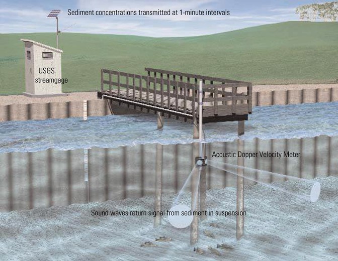
Surrogate monitoring for suspended sediment
Click for fullsize image |
The U.S. Geological Survey (USGS) has deployed instruments that collect continuous turbidity and acoustic back-scatter data at sites where suspended sediment concentration [SSC] is sampled through traditional techniques. Relating SSC to this continuous “surrogate” data yields estimates of continuous SSC that reveal the real-world dynamics of this fundamentally important water-quality measure. Real-time, continuous sediment stations have been developed on the Knife, Zumbro, Blue Earth, and Minnesota Rivers through partnerships with the Minnesota Pollution Control Agency, Minnesota Department of Natural Resources, U.S. Army Corps of Engineers, and the Lower Minnesota Watershed District. Surrogate relations currently are being developed for eight additional sites on the Minnesota, Mississippi, and St. Croix Rivers in cooperation with the Legislative-Citizen Commission on Minnesota Resources Environment and Natural Resources Trust Fund. Real-time sediment data are available through the USGS National Real-Time Water Quality website (nrtwq.usgs.gov).
Contact: Joel Groten ([email protected]).
New study uses surrogate measures for suspended sediment and bedload
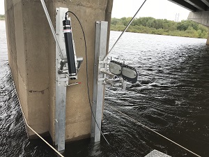
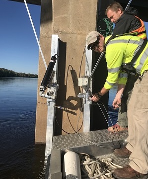
In 2017, our office began a four-year study in cooperation with the U.S. Army Corps of Engineers, the USGS Grand Canyon Monitoring and Research Center, and Northern Arizona University to better understand sediment transport from the Chippewa River in western Wisconsin to the Mississippi River downstream of Lake Pepin. Dual-frequency acoustic velocity meters and an echologger array have been deployed at the Chippewa River at Durand, Wisc.
Data from the acoustic velocity meters will be related to suspended sediment concentration data to distinguish contributions of different particle sizes to suspended sediment loads. Data from the echologger array will be compared to physically-collected bedload samples and data obtained from multibeam surveys of the river channel to estimate bedload contributions to total sediment loads. The U.S. Army Corps of Engineers plans to use results of this study to better predict and prepare for channel closures in the Mississippi River commercial navigation channel caused by sediment deposition from the Chippewa River.
Contact: Jeff Ziegeweid ([email protected]).
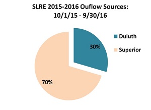
Measuring the complex hydrology of the St. Louis River Estuary
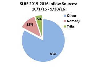
Flows in the St. Louis River Estuary (SLRE) are affected by inflows from multiple tributaries as well as by water exchanges with Lake Superior through two connecting ship entries. Five index-velocity gages were installed in 2015 with funds from the Great Lakes Restoration Initiative to continuously monitor water levels, velocity profiles and discharge in the SLRE.
Water budget calculations for 2016 indicate significant contributions to the water balance from the St. Louis, Nemadji and Pokegama Rivers as well as from the SLRE tributaries near Duluth, MN. These data provide the most detailed quantification of discharge from the SLRE to the nearshore of Lake Superior.
Click for fullsize image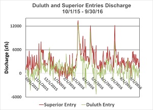 |
High flow events from tributaries have produced complex patterns of discharge into Lake Superior. In 2016, inflow events in March and late April produced outflows from the estuary that quickly changed to a mixture of inflows of lake water through the Duluth Entry and discharge through the Superior Entry.
Observations of changing flow directions and seasonal variation in storm events illustrate why monitoring discharge in both the Duluth Ship Canal and Superior Entry helps us understand how the St. Louis River affects the nearshore of Lake Superior.
Contact: Richard Kiesling ([email protected]).
New study: water-quality concerns in Pipestone National Monument
Photo courtesy of the
National Park Serive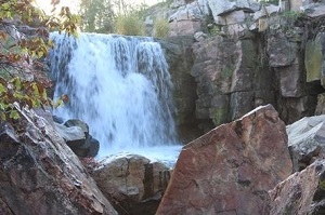 |
Pipestone Creek is listed as impaired and deemed unsuitable for swimming and wading, particularly due to the presence of animal waste. However, Pipestone Creek, which flows through Pipestone Monument, and Winnewissa Falls are considered sacred to Native Americans who bathe in the waters, possibly putting them and other Monument visitors at risk of disease. The USGS and the National Park Service are planning a study to identify water-quality concerns in Pipestone Creek, at Winnewissa Falls viewing area, and in the Pipestone quarries. Work will begin this spring.
Contact: Victoria Christensen ([email protected]).
National publications of interest
Computing continuous loads for the tributary nutrient and sediment monitoring program on the Great Lakes
Water quality (WQ) in many Great Lake tributaries has been degraded (increased nutrient and sediment concentrations) due to changes in their watersheds, resulting in downstream eutrophication. As part of the Great Lakes Water Quality Agreement, specific goals were established for loading of specific constituents (e.g., phosphorus). This new paper develops surrogate relationships to monitored nutrient and sediment data across thirty tributaries to the Great Lakes. Results provide a better understanding of short-term variability and long-term changes in loading affecting the environmental health of the Great Lakes, compared to traditional regression techniques that employ only flow and seasonality parameters.
Link to paper
Contact: Dale Robertson ([email protected]).
The Quality of the Nation's Groundwater: Results from national-scale groundwater monitoring
The U.S. Geological Survey is near the midpoint in the ambitious undertaking to survey the quality of the nation's largest drinking-water resources. This new science feature highlights four new Principal Aquifer studies that are part of this national assessment. Two of the intensely studied Principal Aquifers are of relevance to Minnesota and surrounding states--the Glacial aquifer system and the Cambrian-Ordovician aquifer system--these new fact sheets summarize several comprehensive data sets and interpretive publications on key water quality measures, including trace elements, radionuclides, nitrate, VOCs and pesticides. In the Glacial aquifer system, trace elements were commonly detected at concentrations above human health benchmarks. In the Cambrian-Ordovician aquifer system, radioactive constituents were commonly detected above human health benchmarks. In both aquifer systems, elevated detections of nutrients were infrequent, but more than half of sampled wells had exceedances of non-health benchmarks that cause aesthetic problems, such as staining, taste, or odor.
A related study highlights important new understanding regarding the presence of elevated radionuclides in the Cambrian-Ordovician aquifer. Low oxygen levels and high dissolved minerals are among factors responsible for high concentrations of radium in untreated water from the Cambrian-Ordovician aquifer.
News release
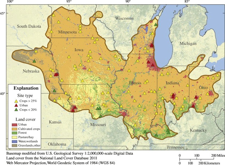
Complex mixtures of dissolved pesticides show potential aquatic toxicity in a synoptic study of Midwestern U.S. streams
Click for fullsize image |
Aquatic organisms in streams are exposed to pesticide mixtures that vary in composition over time in response to changes in flow conditions, pesticide inputs to the stream, and pesticide fate and degradation within the stream. A synoptic study was conducted at 100 streams during May–August 2013 to characterize mixtures of dissolved-phase pesticides and degradates in Midwestern streams. This study documents the most complex pesticide mixtures reported in discrete water samples in the U.S. and, using multiple lines of evidence, predicts that pesticides were potentially toxic to non-target aquatic life in about half of the sampled streams. See Link to paper for more information.
Contact: Lisa Nowell ([email protected]).
Sediment chemistry and sediment toxicity to macroinvertebrate communities in wadeable streams of the Midwest
Sediment chemistry, sediment toxicity, and macroinvertebrate communities were evaluated at 99 wadeable stream sites across 11 states in the Midwestern United States during the summer of 2013 to assess elevated contaminant levels in stream sediment across a large agricultural landscape. This evaluation included polycyclic aromatic hydrocarbons (PAHs), organochlorine compounds, polychlorinated biphenyls (PCBs), polybrominated diphenyl ethers (PBDEs), trace elements, and current-use pesticides; and a mixture assessment based on the ratios of detected compounds to available effects-based benchmarks. Sediments were tested for toxicity with the amphipod Hyalella azteca, the midge Chironomus dilutus, and, at a few sites, with freshwater mussels. Sediment concentrations infrequently exceeded benchmarks for aquatic health, which was generally consistent with low rates of observed toxicity. However, the benchmark-based mixture score and the pyrethroid insecticide bifenthrin were significantly related to observed sediment toxicity. The sediment mixture score and bifenthrin were also significant predictors of the upper limits of several univariate measures of the macroinvertebrate community. The sediment mixture score and bifenthrin have weak, but significant, influence on the observed invertebrate community composition. Together, these three lines of evidence (toxicity tests, univariate metrics, and multivariate community analysis) suggest that elevated contaminant concentrations in sediments, in particular bifenthrin, is limiting macroinvertebrate communities in several of these Midwest streams. See link to paper for more information.
Contact: Patrick Moran ([email protected]).
|
New publications from the USGS in Minnesota
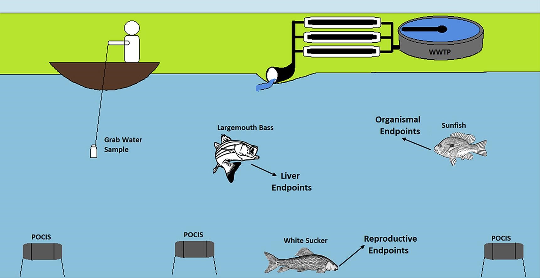
Contaminants of Emerging Concern in Great Lakes tributaries
Click for fullsize image |
A study conducted by USGS, U.S. Fish and Wildlife, and St. Cloud State University characterized the presence of contaminants of emerging concern (CECs) and potential effects to fish in U.S. tributaries to the Great Lakes. Surface water and sediment samples were collected from 12 tributaries in Wisconsin, Illinois, Michigan, Ohio, and New York. CECs such as pharmaceuticals and flame retardants often co-occurred and were indicative of local point sources. Concentrations of some chemicals exceeded benchmarks, indicating that the potential to affect fish and/or macroinvertebrate health was likely. Concurrent with water sample collection, bluegill sunfish were assessed for indices indicative of contaminant exposure in 6 tributaries. Fish were either resident fish collected directly from the tributaries or laboratory-reared fish that were caged for 14 days in the tributary of interest. Many of the fish showed signs of stress, however no direct relationship between adverse effects and specific CECs or classes of CECs was determined. Results from this study can help inform restoration and support management efforts within the Great Lakes Basin.
Findings from this study are reported in three recent papers. The first paper describes patterns of occurrence of CECs in water and streambed sediment. The second paper describes biological consequences of exposure in caged fish. The third paper describes biological consequences of exposure in resident fish and chemical analysis results from Polar Organic Chemical Integrative Samplers (POCIS).
Contact: Sarah Elliott ([email protected]).
Media coverage: St Cloud State TODAY coverage | Minnesota Public Radio coverage
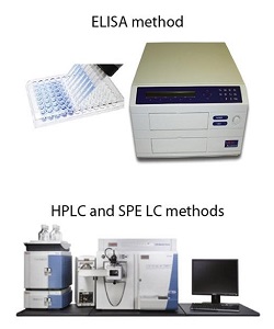
Use of ELISA as a screening tool for Contaminants of Emerging Concern
Sulfamethoxazole and carbamazepine are frequently detected in the environment and can be used as indicators of a wastewater influence. A semi-quantitative analytical method (enzyme-linked immunosorbent assay or ELISA) is available for determination of these compounds and offers a relatively inexpensive and time efficient alternative to mass-spectrometry methods for screening environmental samples. Data produced using both ELISA and mass spectrometry-based methods were compared to assess agreement between methods. False positive and false negative results were minimal. Although ELISA tests for a given chemical may exhibit cross-reactivity with similar chemicals, this study showed agreement between ELISA and mass spectrometry-based methods, with no apparent bias. Results indicate that ELISA provides a cost-effective alternative for screening environmental samples for sulfamethoxazole and carbamazepine.
Link to paper
Contact: Sarah Elliott ([email protected]).
New study quantifies groundwater discharge to Mississippi River in the I-94 corridor
The Interstate 94 Corridor has been identified as 1 of 16 Minnesota groundwater areas of concern because of its limited available groundwater resources. The U.S. Geological Survey, in cooperation with the Minnesota Department of Natural Resources, completed six seasonal and annual groundwater balances for parts of the Interstate 94 Corridor surficial aquifer to better understand its long-term (next several decades) sustainability. A high-precision Mississippi River groundwater discharge measurement was completed at low-flow conditions to better inform these groundwater balances. The recharge calculation methods using two separate approaches were used to inform the groundwater balances.
Calculated groundwater discharges ranged from 1.45 to 5.06 cubic feet per second per mile, a ratio of 27.7 to 96.4 percent of the measured groundwater discharge. Ratios of groundwater pumping to total recharge ranged from 8.6 to 97.2 percent, with the longer-term groundwater balances ranging from 12.9 to 19 percent. Methods presented in the report establish the framework for future groundwater modeling efforts.
Contact: Erik Smith ([email protected]).
Weathering of Oil in a Surficial Aquifer
Click for fullsize image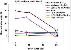 |
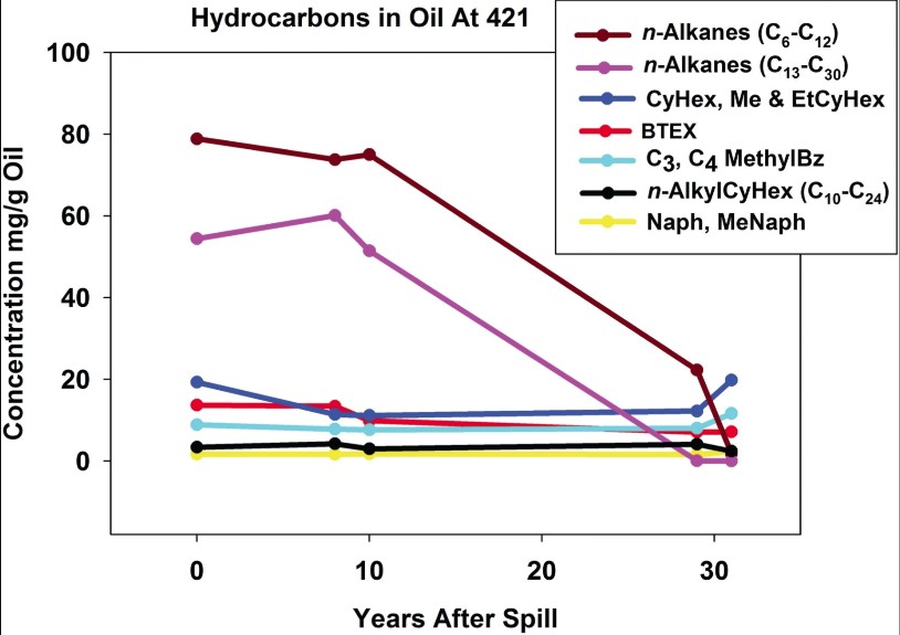
What happens to crude oil that's left in the ground for nature to clean up? A new paper examines weathering and degradation of crude oil over 30 years at the National Crude Oil Spill Fate and Natural Attenuation Research Site near Bemidji, MN. Crude oil contains many classes of compounds which are removed from the spilled oil at different rates. The figure to the right is an example of how concentrations of different classes of compounds changed through time at well 421 at the Site. Short-chained n-alkanes, originally the highest concentration in oil, are almost gone after 30 years whereas cyclohexane, methyl and ethylcyclohexane (CyHex, Me & EtCyHex) concentrations have slightly increased through time. The weathering of oil in the groundwater depends on many factors and is variable within the oil body. One implication for water quality is that although there has been significant degradation of the oil, some components will remain for the long term and continue to be a source of contamination to the groundwater. Overall, the oil chemistry indicates that the oil mass has been reduced by 18% to 31% over 30 years.
Link to paper
Contact: Jared Trost ([email protected]).
Comparability of river suspended-sediment sampling and laboratory analysis methods
Accurate measurements of suspended sediment concentration, a leading water-quality impairment in many Minnesota rivers, are important for managing and protecting water resources. However, water-quality standards for suspended sediment in Minnesota are based on grab field sampling and total suspended solids (TSS) laboratory analysis methods that may under-represent concentrations of suspended sediment in rivers. The U.S. Geological Survey, in collaboration with the Minnesota Pollution Control Agency, collected concurrent grab and equal-width or equal-discharge increment samples at eight sites to compare results obtained using different combinations of field sampling and laboratory analysis methods.
Grab field sampling and TSS laboratory analysis results were biased substantially low compared to EWDI sampling and SSC laboratory analysis results, respectively. Grab field sampling and TSS laboratory analysis methods fail to capture most of the sand being transported by the stream, with less of a difference for fine sediment. However, strong correlations between SSC and TSS provides the opportunity to develop site specific relations to address transport processes not captured by grab field sampling and TSS laboratory analysis methods. See report for more information.
Contact: Joel Groten ([email protected]).
Staff Notes
Farewell Ron Wencl
Ron Wencl, USGS Geospatial Information Liaison in Minnesota, retired after 38 years of Federal service with the U.S. Navy and the USGS. Ron was recognized in October with the Minnesota Geographic Information System/Land Information System Consortium's Lifetime Achievement award.
One of the many testimonials of Ron's service to the geospatial data community is copied here:
Ron was an essential partner and promoter of getting Minnesota elevation data that was derived from LiDAR into the National Elevation Dataset and in the updated digital topographic maps for Minnesota. The data is now available to the entire geospatial community and more importantly the public. --Dan Ross, Minnesota Chief Information Officer
Congratulations on your retirement, Ron. We'll miss your booming voice.
Welcome Anna Baker
Anna Baker recently joined the USGS Minnesota office as a full-time Hydrologist following the defense of her master's thesis. Her master's work focused on examining the role of sediment in driving phosphorus dynamics in the Le Sueur River basin. Though she remains fascinated by sediment chemistry and surface water quality, she is excited to be returning to her roots in focusing on groundwater-surface water interactions. She is working with Tim Cowdery on the development of a groundwater model that will explore the influence of iron mining on the hydrology of the upper St. Louis River Basin, an effort that is being undertaken in collaboration with the Fond du Lac Band of Lake Superior Chippewa.
Andrew Berg--Civil Servant of the Year
Andrew Berg was named our 2018 Civil Servant of the Year. Andrew is the one of the most professional and meticulous hydrologic technicians many of the Minnesota USGS staff have ever worked with. We feel absolutely confident work completed by Andrew is to the highest standards. In 2017, Andrew was integral to successful data collection efforts for several large projects, including the southeast Minnesota drainage impacts on recharge project, Bemidji oil-spill site, and the confining beds project. Andrew is a quiet leader, both in the field and in the office. Congrats Andrew!
Jim Stark hired as Director of the Legislative Water Commission
Jim Stark, emeritus scientist and retired Director of the USGS's Minnesota Water Science Center, could not stay retired. Jim was hired in March as Director of the Legislative Water Commission. The LWC reviews water policy and reports, and makes recommendations to assist the legislature in formulating water-related legislation. We're sure that Jim's wealth of knowledge and professional contacts on water issues in Minnesota will serve the LWC well.
|