Recharge Processes
on the Trout Creek and Cottonwood Creek Alluvial Fans, North-Central Nevada
by Russ Plume (rwplume@usgs.gov)
Trout and Cottonwood
Creeks are ephemeral tributaries of the Humboldt River in north-central Nevada
(Figs. 1 and 2). Because they are typical of numerous streams that drain small
watersheds in the Humboldt River Basin, the site of these two watersheds was
chosen as one of five study sites for ground-water recharge processes on
alluvial fans by the USGS Southwest Ground-Water Resources Project (http://az.water.usgs.gov.swgwrp/Pages/Overview.html).
The Humboldt River Basin Assessment (http://nevada.usgs.gov/humb/)
also supports the Trout-Cottonwood study. The objectives of the study, which
runs from 1999 to 2003, are: (1) to quantify ground-water recharge that results
from mountain block runoff along the two stream channels and from precipitation
that falls directly on the alluvial fan, and (2) to quantify subsurface
ground-water flow from the mountain block into adjacent alluvial-fan deposits.
Altitudes of both
watersheds range from about 1,340 m (4,400 ft) along the edge of the Humboldt
River flood plain to 2,500 m (8,200 ft) in the headwaters areas on Battle
Mountain. From the headwaters, each stream flows northwest and north in a
rugged canyon that is incised into faulted and fractured cherts, shales,
siltstones, sandstones, quartzites, and subordinate limestones of Paleozoic
age. At the mountain front, both streams turn to the northeast and flow about
11 km (7 mi) across a broad, gently sloping alluvial fan to the Humboldt River
flood plain. During years of at least average winter precipitation on Battle
Mountain, flows of Trout and Cottonwood Creeks may reach the Humboldt River in
late spring to early summer. During drought years, the flows may not even reach
the alluvial fan-mountain block contact.
Measurement of streamflow,
soil and water temperature, soil moisture, and the chloride content of the
unsaturated zone will provide four independent estimates of recharge rates on
the alluvial fan. Mining companies have installed several monitoring wells in
the mountain block and alluvial fan. Water levels, hydraulic properties, and
chloride analyses of ground water from these wells will be used to estimate
subsurface flow across the alluvial fan-mountain block contact.
In spring of 2000, the
study is in the early phase of data collection. Because of funding limitations,
much of the study emphasizes Trout Creek. Miscellaneous measurements of
streamflow in late spring and early summer 1999, and in 2000, provided an
initial indication of the potential timing and magnitude of flows in both
streams, and of flow losses across the alluvial fan. Present data collection
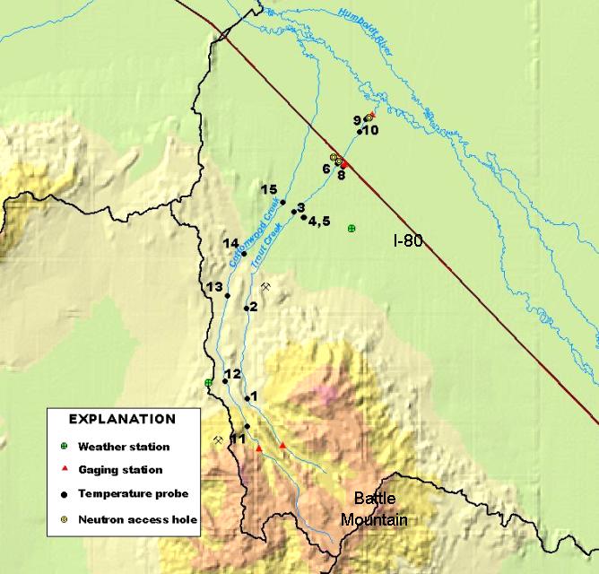
includes: (1) continued streamflow measurements at nine sites; (2) continuous
measurement of streamflow at five gaging stations; (3) measurement of
soil-surface and runoff temperature using Onsett temperature probes at 13
sites; (4) measurement of infiltration temperatures at depths of 10, 20, 50,
100, 150, and 200 centimeters using thermocouples at four sites; and (5)
collection of meteorological data and chloride dryfall and wetfall at two
weather stations. Data collection will continue for the next two runoff seasons
(2001-02). The report of study findings will be completed and released by 2003.
For more information,
contact Dave Prudic (775-887-7611) or Russ Plume (775-887-7612).
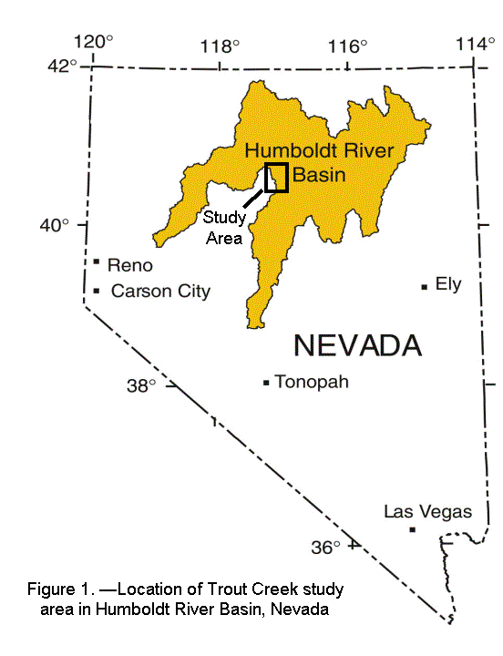
Figure 2. —Study area data
collection sites. 2.--