Minnesota Water Science Center Newsletter
Winter 2011-2012
U.S. Geological Survey
Minnesota Water Science Center
2280 Woodale Drive
Mounds View, MN 55112
http://mn.water.usgs.gov
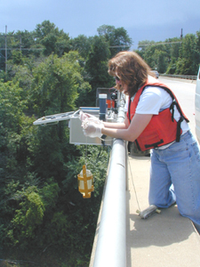
Employee Spotlight-Vicki Christensen
 |
Spring Flood Outlook
With most of Minnesota experiencing below normal precipitation since August, most streams in Minnesota have receded to normal- or below-normal streamflow rates for this time of year. This is illustrated by recent streamflow conditions compared to historical for the Minnesota River near Jordan. This graph shows recent streamflow conditions compared to historical for the Minnesota River near Jordan. As of late January 2012, nearly all of Minnesota was experiencing moderate- to severe-drought conditions. Probabilistic flood forecasts issued for rivers in Minnesota by the National Weather Service (NWS) generally indicate a below-normal chance of flooding. Probabilistic flood forecasts (using USGS streamgage data) for rivers near the Twin Cities can be accessed on the NWS web site. Flood potential can change quickly, so stay tuned.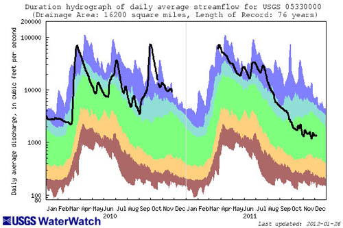
A Minnesota Legacy
Tom Winter worked for the U.S. Geological Survey for 37 years. Although Tom relocated to Colorado in 1973, he always cherished his roots in Minnesota. The Fort Snelling area was one of the family's favorite recreation areas for several generations. Tom recalled that his parents would often take out-of-town visitors to Pilot Knob to see Fort Snelling and the confluence of the Mississippi and Minnesota Rivers. Tom wanted to do something special at Fort Snelling that would be a lasting tribute to his parents and his brother Joseph. With a small inheritance he received when his brother died, he decided to create The Joseph and Marie Winter Family Fund for Historic Fort Snelling-a pooled fund that he hoped to build into an individual named fund over time.Tom passed away suddenly in 2010. To honor him, his children-Mark and Mike Winter, and Shelley Hall-decided to complete the pledge their father had made to bring the fund to $50,000. In addition to completing the fund, they also wanted to remember their father at Fort Snelling. In 2011, Tom's family and friends gathered at Fort Snelling to dedicate an oak tree (his favorite tree) in the picnic area overlooking the bend in the Mississippi River gorge. Family members plan to continue contributing to the fund to honor Tom and their family's history in Minnesota.
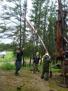
Bemidji Research Site - June 11-12, 2012
 |
The symposium will include several elements:
- Technical presentation of results
- Development of a successful, long-term, cooperative, interdisciplinary research site
- Natural attenuation processes
- Innovative investigation techniques
- A panel discussion, which will include remediation practitioners, regulators, and researchers sharing ideas about how to foster communication and bring academic research results into practice
- A session to brainstorm future communication ideas
- How can remediation practitioners and regulators better communicate knowledge gaps to academic researchers, to foster new research directions?
- How can academic researchers better communicate important results to remediation practitioners and regulators?
Contact: Mindy Erickson - Site Manager
White Bear Lake Project Update
 |
Total groundwater extraction rates increased from high-capacity wells in the White Bear Lake area from 1980 to 1990 in the study area, but have fluctuated since 1990. Over the past 30 years, municipal water use accounts for 87 percent of the total groundwater extraction, with 90 percent of the total groundwater extraction occurring from the Prairie du Chien/Jordan aquifer. The largest groundwater extraction rates occur in the cities of White Bear Lake and Oakdale, with annual extraction rates in Oakdale gradually increasing from 375 million gallons in 1980 to 887 million gallons in 2010. Over the past 9 years, groundwater extraction rates have increased in some municipalities north of White Bear Lake, with a substantial increase in total groundwater extraction north of the lake. Seasonal trends in municipal pumping rates are being analyzed. Other study activities include creating potentiometric contours for glacial and bedrock, determination of major ion chemistry of White Bear Lake, and analysis of isotope data for surface-water, precipitation, groundwater, and lake-sediment pore water samples.
Contact: Perry Jones
New project Highlight: Groundwater Recharge
Groundwater recharge is one of the most important unknowns for estimating water budgets, calibrating groundwater models, and assessing contaminant transport, aquifer replenishment, and water-quality protection. Recharge is highly variable both spatially and temporally, making accurate estimates at a regional scale difficult to ascertain. Point estimates of recharge are not appropriate for regional-scale models, and multi-year hydrologic assessments based on static recharge estimates can lead to large miscalculations in the overall water budget. Several techniques currently exist to estimate variable recharge rates. However, consideration must be given for not only the most appropriate method for quantifying the recharge rates but also the ease of use and the availability of the required input data. The objectives of a new study by the USGS, in cooperation with the MPCA, are to provide a reasonable statewide estimate of recharge using the Soil-Water-Balance (SWB) model, validate the simulation results, and conduct a parameter sensitivity analysis to identify the most sensitive model parameters. For the purposes of this application of the SWB model, the simulation results will be conducted on selected watershed basins in the State and compared against previously established recharge estimates. Using a gridded data structure, these new temporally and spatially distributed recharge estimates can be easily integrated into regional groundwater-flow models.Contact: Erik Smith
USGS Topographic Maps Online - New and Old
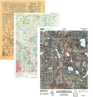 |
US Topo maps are available free on the Web through the USGS Store. Each map quadrangle is constructed in PDF format from key layers of geographic data-orthoimagery, roads, geographic names, contours, and hydrographic features-found in The National Map. New US Topo maps were produced for Minnesota in 2010. The complete series of USGS Historical Topographic Maps for Minnesota also is available for viewing and download.
Contact: Ron Wencl
Precision Conservation: Technology Redefining Local Water Quality Practices
Conference sponsored by the Freshwater Society, March 29
Precision conservation targets scarce resources to the spots on the landscape where they will do the most good. Learn about the latest technology -- much of it based on LiDAR scanning - that pinpoints "sweet spots" where runoff, erosion and pollution are disproportionately great and the potential for improvement is disproportionately great. The conference will feature talks by: Dave White, Chief of the Natural Resources Conservation Service; Dr. Dave Mulla from the University of Minnesota; and water-quality planners and practitioners from SWCDs and watershed districts across the state.Learn more and register at www.freshwater.org
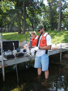
Monitoring Sediment in Streams
Sediment enriched rivers and streams pose substantial environmental and economic challenges for State agencies and local governments. A rekindling of interest in fluvial sediment has resulted in substantial growth in USGS's sediment program. Understanding sediment transport relations are critical for flood level computations, fish habitat assessments, development of total maximum daily load (TMDL) criteria, river restoration plans, and effectively managing and protecting water resources. Excessive sedimentation is the primary transport mechanism of toxic organic chemicals, heavy metals, and nutrients, and is the leading impairment in Minnesota's rivers and streams, affecting more than 5,800 miles of streams throughout the State. Sediment will likely be listed as the main stressor in nearly all impaired biota TMDLs. Because of this, collecting both suspended-sediment concentrations (SSC) and bed-load sediment concentrations are needed to understand the timing, frequency, and magnitude of total sediment transport, and its relation with streamflow.The absence of sediment data commonly is attributed to the difficulty, expense, training requirements, and timeliness of event flows. Sediment sampling involves deploying cumbersome reel and crane systems with heavy samplers often during adverse conditions. Because sediment concentrations can vary substantially with stream depths, widths, and velocities, specific training is needed to obtain samples that accurately represent SSC in the stream. The emphasis to better understand sediment transport relations by the Minnesota Pollution Control Agency (MPCA) and the Minnesota Department of Natural Resources (MDNR) is in part, due to the relation between sediment transport and stream geomorphology, which in turn, is directly linked to river restoration and stream ecological health. The current cadre of eight sediment sampling sites in Minnesota is built on an existing network of USGS and DNR streamgages. A new collaborative study among USGS, MPCA, and the MDNR will likely increase the number of sampling sites within the next year.
New tools and techniques for use in characterizing sediment in streams have become available and are being incorporated into the network. The new tools involve the use of continuous turbidity monitoring and hydroacoustic technology. Continuous turbidity monitoring is being used at locations on the Zumbro River, Des Moines River, Rice Creek, and South Branch Buffalo River. In most cases, continuous turbidity monitoring is an improvement over the use of streamflow to predict SSC. Continuous turbidity monitoring provides real-time SSC monitoring and yields important information related to water-quality criteria for TMDL development. Hydroacoustics is a nonintrusive technique that uses sound waves to measure SSC. Hydroacoustics monitoring is planned for the Minnesota River. Additionally, two sites on the Root River are in the planning stages for a "supergage." This supergage will provide continuous measurements of streamflow, SSC, and nitrate concentrations using high-resolution sonar backscatter, optics, and ultraviolet light. In addition to collaborating with the MPCA and MDNR, the USGS has partnered with the U.S. Army Corps of Engineers, Rice Creek Watershed District, and the Wild Rice River Watershed to improve understanding of both sediment and bed-load transport rates using both traditional and newer technologies.
Contact: Chris Ellison
The following journal article has been published
"Temporal changes in aquatic-invertebrate and fish assemblages in streams of the north-central and northeastern US," by Jonathan G. Kennen, Daniel J. Sullivan, Jason T. May, Amanda H. Bell, Karen M. Beaulieu, and Donald E. Rice. This article is available online. This article is the second in a series of ecological trends reports from the National Water-Quality Assessment (NAWQA) Program's major river basin studies.Article Abstract: Many management agencies seek to evaluate temporal changes in aquatic assemblages at monitoring sites, but few have sites with ecological time series that are long enough for this purpose. Trends in aquatic-invertebrate and fish assemblage composition were assessed at 27 long-term monitoring sites in the north-central and northeastern United States. Temporal changes were identified using serial trend analysis. Sites with significant serial trends were further evaluated by relating explanatory environmental variables (e.g., streamflow, habitat, and water chemistry) to changes in assemblage composition. Significant trends were found at 19 of 27 study sites; however, differences in the sensitivity of the aquatic fauna to environmental stressors were identified. For example, significant trends in fish assemblages were found at more sites (15 of 27) than for aquatic-invertebrate assemblages (10 of 27 sites). In addition, trends in the invertebrate assemblage were most often explained by changes in streamflow processes (e.g., duration and magnitude of low- and high-flows, streamflow variability, and annual rates of change), whereas trends in the fish assemblage were more related to changes in water chemistry. Results illustrate the value of long-term monitoring for the purpose of assessing temporal trends in aquatic assemblages. The ability to detect trends in assemblage composition and to attribute these changes to environmental factors is necessary to understand mechanistic pathways and to further our understanding of how incremental anthropogenic alterations modify aquatic assemblages over time. Finally, this study's approach to trends analysis can be used to better inform the design of monitoring programs as well as support the ongoing management needs of stakeholders, water-resource agencies, and policy makers.
For additional information please contact the lead authors (Jonathan Kennen, Dan Sullivan), or the Surface Water Status and Trends Coordinator (Charlie Crawford).
USGS Scientific Investigations Report 2011-5200 has been published
 |
This report is available online.
Report Abstract: Trends in loads and concentrations of suspended sediment and suspended sand generally were downward for stations within the Mississippi River Basin during the 60-, 34-, and 12-year periods analyzed. Sediment transport in the lower Mississippi River has historically been, and continues to be, most closely correlative to sediment contributions from the Missouri River, which generally carried the largest annual suspended-sediment load of the major Mississippi River subbasins. The closure of Fort Randall Dam in the upper Missouri River in 1952 was the single largest event in the recorded historical decline of suspended-sediment loads in the Mississippi River Basin. Impoundments on tributaries and sediment reductions as a result of implementation of agricultural conservation practices throughout the basin likely account for much of the remaining Mississippi River sediment transport decline. Scour of the main-stem channel downstream from the upper Missouri River impoundments is likely the largest source of suspended sand in the lower Missouri River. The Ohio River was second to the Missouri River in terms of sediment contributions, followed by the upper Mississippi and Arkansas Rivers. Declines in sediment loads and concentrations continued through the most recent analysis period (1998-2009) at available Mississippi River Basin stations. Analyses of flow-adjusted concentrations of suspended sediment indicate the recent downward temporal changes generally can be explained by corresponding decreases in streams.
The following journal article has been released
"Fate of 4-Nonylphenol and 17β-Estradiol in the Redwood River of Minnesota," by Jeffrey H. Writer, Joseph N. Ryan, Steffanie H. Keefe, and Larry B. Barber. This article is in press with Environmental Science and Technology and currently is available online.Article Abstract: The majority of previous research investigating the fate of endocrine-disrupting compounds has focused on single processes generally in controlled laboratory experiments, and limited studies have directly evaluated their fate and transport in rivers. This study evaluated the fate and transport of 4-nonylphenol, 17β-estradiol, and estrone in a 10-km reach of the Redwood River in southwestern Minnesota. The same parcel of water was sampled as it moved downstream, integrating chemical transformation and hydrologic processes. The conservative tracer bromide was used to track the parcel of water being sampled, and the change in mass of the target compounds relative to bromide was determined at two locations downstream from a wastewater treatment plant effluent outfall. In-stream attenuation coefficients (kstream) were calculated by assuming first-order kinetics (negative values correspond to attenuation, whereas positive values indicate production). Attenuation of 17β-estradiol (kstream = -3.2 ± 1.0 day-1) was attributed primarily due to sorption and biodegradation by the stream biofilm and bed sediments. Estrone (kstream = 0.6 ± 0.8 day-1) and 4-nonylphenol (kstream = 1.4 ± 1.9 day-1) were produced in the evaluated 10-km reach, likely due to biochemical transformation from parent compounds (17β-estradiol, 4-nonylphenolpolyethoxylates, and 4-nonyphenolpolyethoxycarboxylates). Despite attenuation, these compounds were transported kilometers downstream, and thus additive concentrations from multiple sources and transformation of parent compounds into degradates having estrogenic activity can explain their environmental persistence and widespread observations of biological disruption in surface waters.
USGS Scientific Investigations Report 2011-5208 has been published
 |
Report Abstract: The U.S. Geological Survey and the National Park Service cooperated on a study to determine the occurrence of wastewater indicator compounds including nutrients; organic wastewater compounds (OWCs), such as compounds used in plastic components, surfactant metabolites, antimicrobials, fragrances, and fire retardants; and pharmaceuticals in the St. Croix National Scenic Riverway in Minnesota and Wisconsin. Samples of treated wastewater effluent from two wastewater-treatment plants (WWTPs), located in St. Croix Falls, Wisc. (SCF-WWTP) and Taylors Falls, Minn. (TF-WWTP), were collected from 2007 to 2008. During this time, surface-water and bed-sediment samples from the St. Croix River below Sunrise River near Sunrise, Minn., upstream from the two WWTPs (Sunrise site), and from the St. Croix River above Rock Island near Franconia, Minn., downstream from the WWTPs (Franconia site), also were collected. The Franconia site was selected because of the two large WWTP discharge points and the presence of mussel beds in this area of the St. Croix River.
A variety of OWCs and pharmaceuticals were detected in wastewater effluent from both WWTPs. Compounds detected varied between the two WWTPs and varied over time from samples collected at each site. The concentration and numbers of OWCs detected were greater in the wastewater effluent samples from SCF-WWTP (38 OWCs and 7 pharmaceuticals detected) than from TF-WWTP (20 OWCs and 3 pharmaceuticals detected). Four endocrine active compounds, compounds known to affect the endocrine systems of fish-4-nonylphenol, 4-nonylphenol diethoxylate, acetyl hexamethyl tetrahydronaphthalene, and hexahydrohexamethyl cyclopentabenzopyran- also were detected in effluent samples from both WWTPs. Concentrations of phosphate flame retardants were greater in effluent from SCF-WWTP than from TF-WWTP with the concentration of tris(2-butoxyethyl) phosphate greater than 200 micrograms per liter. Seven OWCs, including one endocrine active compound, and two pharmaceuticals were detected in surface-water samples from the Sunrise site. Twelve OWCs and three pharmaceuticals were detected in surface-water samples from the Franconia site. Eighteen OWCs were detected in bed-sediment samples from the Sunrise site, whereas 21 OWCs were detected in bed-sediment samples from the Franconia site. Eight pharmaceuticals were detected in bed-sediment samples from both sites.
The results of this study indicate that aquatic biota in the St. Croix River are exposed to a wide variety of organic contaminants that originate from diverse sources including WWTP effluent. The data on wastewater indicator compounds indicate that exposures are temporally and spatially variable and that OWCs may accumulate in bed sediment. These results also indicate that OWCs in water and bed sediment increase downstream from discharges of wastewater effluent to the St. Croix River; however, the presence of OWCs in surface water and bed sediment at the Sunrise site indicates that potential sources of compounds, such as WWTPs or other sources, are upstream from the Taylors Falls-St. Croix Falls area.
USGS Data Series 663 report published
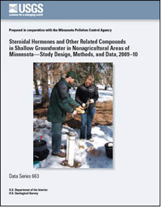 |
Report Abstract: The U.S. Geological Survey, in cooperation with the Minnesota Pollution Control Agency, completed a study on the occurrence of steroidal hormones and other endocrine active compounds in shallow groundwater in nonagricultural areas of Minnesota during 2009-10. This report describes the study design and methods, and presents the data collected on steroidal hormones and other related compounds. Environmental and quality-control samples were collected from 40 wells as part of this study. Samples were analyzed by the U.S. Geological Survey National Water Quality Laboratory for 16 steroidal hormones and 4 other related compounds, of which all but 2 compounds are endocrine active compounds. Most of the water samples did not contain detectable concentrations of any of the 20 compounds analyzed. Water samples from three wells had detectable concentrations of one or more compounds. Bisphenol A was detected in samples from three wells, and trans-diethylstilbestrol was detected in one of the samples in which bisphenol A also was detected.