Minnesota Water Science Center Newsletter
Summer 2012
U.S. Geological Survey
Minnesota Water Science Center
2280 Woodale Drive
Mounds View, MN 55112
http://mn.water.usgs.gov
I-94 Growth Corridor Update
 |
In order to assess groundwater sustainability in the I-94 growth corridor, a 4-year, collaborative effort between the Minnesota Department of Natural Resources (DNR) and the U.S. Geological Survey (USGS) will provide a foundation to inform local agency partners and communities in planning for sustainable future land and water use. The USGS will collect continuous groundwater levels from representative sites in the Corridor and gather water use data to assist in a groundwater mass-balance analysis of the surficial aquifer of the Anoka Sand Plain. The information developed will build a foundation for future work that can aid corridor communities in making management decisions to sustainably meet the needs of the growing population. The focus on sustainability will help characterize the groundwater balance - the full inventory and all major flows and exchanges - that can be used to support human and ecosystem needs now and in the future.
Contact: Erik Smith
Minnesota Water Resources Conference, October 16-17, 2012, Saint Paul River Centre
Save the date for the Minnesota Water Resources Conference. This annual conference presents innovative and practical water-resource engineering solutions, management techniques, and current research about Minnesota’s water resources. The conference provides an opportunity to address – 1) lessons learned from the implementation of engineering projects; 2) best practices discovered in the design and application of water resource management techniques, 3) implications of water policy decisions, and 4) research on current and emerging issues. The conference facilitates interaction among engineers, water resources managers, researchers, and local, State and Federal agency staff.
Northern Minnesota Flooding, June 19-20
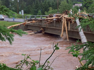 |
Rain fell across the divide of three major basins: Lake Superior and parts of the headwaters of the Mississippi and St Croix River Basins. Tributaries in these basins have different physical settings, causing different stream responses to the heavy rains. Tributaries immediate to Lake Superior in the Duluth area have high relief and bedrock channels. These streams peaked first with very high velocities (observed velocities of as much as 16 feet per second) and caused severe damage to roads and infrastructure in the Duluth area. Upland areas draining to Lake Superior contain lakes and wetlands that may have delayed the time to peak and the duration of the flood peaks. Similarly, delayed peaks were observed in the Mississippi River near Aitkin, located downstream from large areas of wetlands and lakes. A table of streamgage with notable flood peaks and their provisional values is below.
Basin |
Station number |
Station name |
Peak |
Peak flow, cubic feet per second |
Rank of peak flow |
Years |
Lake |
04015330 |
Knife River near Two Harbors, Minnesota |
12.65 |
Not yet determined |
1 |
37 |
Lake |
04024000 |
St. Louis River at Scanlon, Minnesota |
16.62 |
45,300 |
1 |
104 |
Mississippi |
05227500 |
Mississippi River at Aitkin, Minnesota |
18.71 |
15,100 |
2 |
112 |
Mississippi |
05242300 |
Mississippi River at Brainerd, Minnesota |
17.61 |
17,900 |
1 |
24 |
St. Croix |
05336700 |
Kettle River below Sandstone, Minnesota |
17.96 |
23,300 |
1 |
45 |
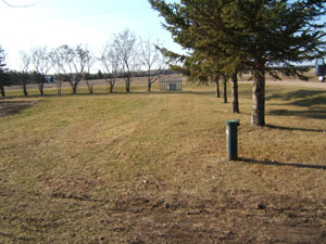
White Bear Lake Update
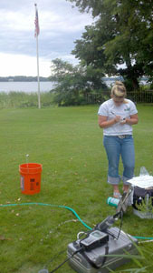 |
Contact: Perry Jones
LCCMR Update
In July the Minnesota Legislative-Citizen Commission on Minnesota Resources (LCCMR) completed this year’s competitive process for making recommendations about funding for special environment and natural resources projects. The LCCMR’s recommendations to the 2013 Legislature provide a total of approximately $36.6 million from the Minnesota Lottery generated Environment and Natural Resources Trust Fund to 48 projects to begin in 2013. The selected projects address an array of issues facing Minnesota’s land, water, fish, and wildlife. Several proposals that include involvement by the USGS Minnesota Water Science Center or the USGS Upper Mississippi River Environmental Sciences Center were recommended for funding. These include projects with focus on lake ecosystems (in partnership with the Minnesota Department of Natural Resources) , background water-quality characterization in northeastern Minnesota prior to potential mining (in partnership with the Natural Resources Research Institute), control of invasive mussels, and prairie wetland restoration (in partnership with the Red Lake Watershed District). The LCCMR’s recommendations will now go before the 2013 Legislature for consideration and approval. Work for recommended projects will begin on July 1, 2013, when the funds become available.
National Research Program
Each year the USGS National Research Program offers lectures on various topics to selected field offices. The Minnesota Water Science Center is pleased to announce the next lecture by Brian Pellerin on September 27, 2012. The lecture will be held at the Minnesota Water Science Center. Following the morning presentation we will have an informal pizza lunch at the office to provide a time to talk informally with Chris. Please let us know if you plan to attend and if you are interested in staying for lunch. Details are included at the end of this note. A presentation summary and information about Brian follows:
Seeing the light: Applications of in-situ optical sensors for high frequency water quality monitoring and research
Brian A. Pellerin
A challenge for accurately measuring the sources, loads and cycling of dissolved organic matter (DOM) and nutrients is making measurements at the time scales in which changes occur in aquatic systems. Traditional approaches for data collection (daily to monthly discrete samples) are often limited by high analytical and field costs, difficult site access, and logistical challenges, particularly for long-term sampling at a large number of sites. The ability to make optical measurements (absorbance and fluorescence) in-situ has been known for more than 50 years, but much of the work using commercially-available sensors in rivers and streams has taken place in only the last few years. Relatively simple optical measurements made in-situ are being incorporated into several USGS research and monitoring programs, resulting in advanced understanding of constituent loads, sources, and cycling in freshwater systems. This talk will present several examples from rivers and streams that highlight the application of continuous optical measurements for understanding DOM and nutrient dynamics at intervals of minutes to hours, as well as proxy measurements for constituents that are significantly more difficult and expensive to measure at high frequencies such as methylmercury and trihalomethane.
Short bio: Received B.S. (1998) and Ph.D. (2004) from the University of New Hampshire, M.S. (2000) from the University of Maine. - The Ph.D. degree was in the interdisciplinary Natural Resources and Earth Systems Science program and focused on the hydrology and nutrient biogeochemistry of small urban watersheds. Brian has been at the USGS California Water Science Center since 2004 as a National Research Council post-doctoral researcher (2004-2007) and Soil Scientist/Research Soil Scientist (2007-present). Most of Brian’s current work is on the use of in situ optical sensors for carbon and nutrients in small watersheds and large coastal rivers across the country.
Professional Development Credit: There will be a sign-up sheet at the lecture for those who are interested in applying for one hour Professional Development credit by the Minnesota Board of Architecture, Engineering, Land Surveying, Landscape Architecture, Geosciences, and Interior Design (AELSLAGID). We need an estimate before the meeting about who plans to attend. Please contact Lindsay Forbes by email ([email protected]) or by phone/voicemail (763-783-3100) with your name and affiliation. Please let us know if you plan to attend by the Monday preceding the lecture.
Also, please let Lindsay know if you are interested in having lunch with Brian. The cost will be $5.00.
Directions to the Minnesota Water Science Center
Employee Spotlight: Lisa Syde-Hagen
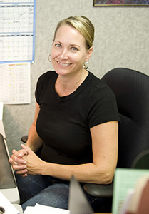 |
Lisa is a vital Administrative Section employee and is responsible for maintaining the Center's funding data, processing of proposals and Joint Funding Agreements. Lisa plays a key role in the development of the Common Service Rate workbook which provides an important aspect to understanding the financial status of the Center. Lisa serves as the Property Officer and contact, and as the Contracting Officers Representative, provides advice and recommendations for major procurements including preparation and submission of all documents and justifications. Lisa has received several Special Service Awards for her work and is a valuable asset to the Center's Administrative support staff.
Midwest Groundwater Conference, October 1-3, 2012, Earle Brown Heritage Center
The Midwest Groundwater Conference will be held in Minneapolis this year. This annual meeting is held at the invitation of a participating State. The conference provides an opportunity for hydrogeologists, geologists, engineers, students, and others studying groundwater resources in their respective States to meet and exchange ideas, discuss mutual problems affecting the Midwest, and summarize results of field and laboratory studies. Registration is now open. For details, please visit: http://www.mwgwc.org

Areas of Elevated Contaminants in Groundwater Determined from Regional Assessment in the Midwest
At least one contaminant was found at levels of human-health concern in about one third of untreated groundwater samples collected from wells in the Cambrian-Ordovician aquifer system, according to a recent report by the U.S. Geological Survey. When radon concentrations greater than 300 picocuries per liter are included, 64 percent of wells sampled contain a contaminant concentration above a human-health benchmark.
The Cambrian-Ordovician aquifer system is ranked ninth in the Nation for public supply water withdrawals from principal aquifers. The aquifer supplies water to many parts of the northern Midwest, including areas of Minnesota, Wisconsin, Illinois, Iowa, Missouri, and the Upper Peninsula of Michigan, as well as the major cities of Minneapolis and Chicago.
Many of the public and private wells sampled contain natural or manmade contaminants, including radium, radon, boron, strontium, manganese, barium, nitrate, pesticides, and volatile organic compounds. Radon and radium are naturally occurring radioactive elements and known carcinogens. The deeper parts of the aquifer system in Illinois, Iowa, and eastern Wisconsin are vulnerable to high concentrations of radium, boron, and strontium. The shallow areas of the aquifer system in Minnesota, Wisconsin, and the Upper Peninsula of Michigan are vulnerable to radon and manganese. The study was conducted as part of an ongoing systematic assessment of some of the Nation’s most important aquifer systems by the USGS National Water-Quality Assessment (NAWQA) Program. Radon-222 and radium were most frequently measured at concentrations greater than human-health benchmarks, but geographic distributions were related to different depths of the aquifer system. Nitrate was detected at a concentration greater than 1 milligram per liter in 21 percent of the wells sampled. Nine different pesticides were detected in wells from 2002 through 2007, but usually at concentrations substantially below human-health benchmarks. The report is available online.
New report! Seasonal Patterns in Nutrients, Carbon, and Algal Responses in Wadeable Streams within Three Geographically Distinct Areas of the United States, 2007–08
By Kathy E. Lee, David L. Lorenz, James C. Petersen, and John B. Greene
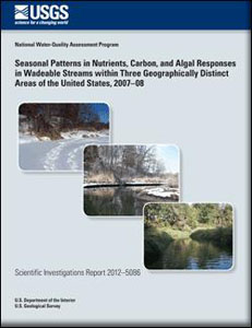 |
Full citation: Lee, K.E., Lorenz, D.L., Petersen, J.C., and Greene, J.B., 2012, Seasonal patterns in nutrients, carbon, and algal responses in wadeable streams within three geographically distinct areas of the United States, 2007–08: U.S. Geological Survey Scientific Investigations Report 2012–5086, 55 p.
Full Report
Contact: Kathy Lee
Updating the Minnesota Water Science Center's Science Plan
Each year, the Minnesota Water Science Center conducts a review of the Center’s Science Plan. This plan is developed by senior technical staff from the Center, technical specialists, and partners. The plan formalizes the current State water issues and the general direction and need for new projects. The plan presents priority issues consistent with the national and regional roles of the USGS and applied to the hydrologic, environmental and cultural settings of Minnesota and the Upper Midwest. As local issues change, the Center modifies the plan in accordance with local issues and USGS priority science issues. One of the priority issues in the revised plan focuses on mining. A short summary of that priority issue is included below. The vision and goals of the plan, as articulated below, focus our efforts on mining-related programs in cooperation with the Legislative-Citizens Commission on Minnesota Resources and Minnesota, Pollution Control Agency, USDA National Forest Service and the USGS Midwest Area. Your comments about this priority issue would be appreciated.
Environmental Effects of Mining
The discovery, extraction, and management of the Nation's mineral resources are vital to the health and well-being of the people of the United States. The value of raw nonfuel minerals mined in the United States was $74 billion in 2011, up from $66 billion in 2010 (U.S. Geological Survey, 2012). Mineral materials processed domestically accounted for more than $575 billion in the U.S. economy in 2007. Growing societal needs for metals will require effective and targeted science related to mineral resources, their extraction, and the effects of their extraction on the surrounding environment.
Based on the most current available data (2008) Minnesota ranks first among all States in iron ore production and fifth for industrial sand and gravel production (U. S. Geological Survey, 2010). In 2011, Minnesota’s raw nonfuel mineral production was valued at $3.43 billion (U.S. Geological Survey, 2010). In addition to iron ore mining, Minnesota contains significant copper, nickel, platinum group metals and gold ore, perhaps the largest unexploited resources of these metals in the United States (Peterson and Albers, 2007). Several large deposits are currently undergoing evaluation or are in the permitting stage.
However, environmental concerns for existing water quality and the sensitive ecosystems of northeastern Minnesota can be at odds with proposed mining development. Concerns related to metal extraction include exposure of sulfide-bearing rocks that can result in elevated metal concentrations in water, potential for destruction of wetlands, degradation of stream aquatic health, and detrimental changes in surface and groundwater by mine dewatering and construction of tailings and other settling ponds (Lottermoser, 2010). Such environmental concerns can be addressed by sound science, societal buy-in, and modern mining methods.
The USGS can provide effective and targeted science to establish the current regional pre-mining baseline geochemistry of the region and create tools to predict effects of proposed mining on water quality. This science will allow Federal, State, local, and tribal entities to make sound public policy based on unbiased scientific data.
In 2010, 13 million metric tons of sand were sold or used in the United States for hydraulic fracturing in natural gas and oil wells (U.S. Geological Survey, 2012). Nearly three-quarters of this “frac sand” is mined in the Midwest and shipped to oil and gas fields in Texas, Pennsylvania, and North Dakota. In southeastern and south central Minnesota, the St. Peter, Jordan, and Wonewoc Sandstones meet the specifications required for hydraulic fracturing. Mining of these units can result in removal of hills and bluffs, water-quality issues, and air and noise pollution.
Vision:
The USGS will provide robust, unbiased scientific data to address environmental issues related to current and proposed mining activities in Minnesota.
Specific goals:
Develop an interdisciplinary approach to data collection in existing and potential mining areas that integrates disciplines and expertise available within the Minnesota Water Science Center.
Establish collaborative relationships with State and Federal partners, tribes, and representatives of mining companies that will emphasize the USGS as a source of the valuable, unbiased science needed for reliable land-management decisions.
Transfer technologies and information to our science partners in such a way that decisions emphasize science.
Continue work with the USGS Midwest Area on the Midwest Mining Initiative.
Contact : Perry Jones