Minnesota Water Science Center Newsletter
Fall 2010
U.S. Geological Survey
Minnesota Water Science Center
2280 Woodale Drive
Mounds View, MN 55112
http://mn.water.usgs.gov
Passing of Tom Winter
Thomas C. Winter, Scientist Emeritus with U.S. Geological Survey (USGS), died at his home on October 8th. Although retired in 2007, Tom never left his USGS home and continued to actively pursue research on lake and wetland hydrology and groundwater/surface-water exchange. His death was sudden and unexpected; the shock and loss will be felt throughout USGS and the broader hydrogeological and limnological communities.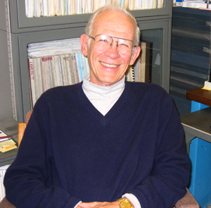 Tom was born and raised in West St. Paul. After receiving BS and MS degrees in geology at the University of Minnesota in 1958 and 1961, Tom began his career with part-time employment with USGS and the University of Minnesota Limnological Research Center. Tom made considerable contributions to the field of palynology until he found permanent employment with USGS in the St. Paul office. Tom spent his early career as a hydrologist drilling hundreds of test holes across the State and interpreting the glacial history of Minnesota. After serving as Minnesota assistant district chief, Tom returned to graduate school at the University of Minnesota to study hydrogeology and the effect of groundwater on lake hydrology. Just prior to finishing his PhD, Tom obtained what he considered to be the best possible position with USGS, working as a research hydrologist with the National Research Program. Over the next 30 years, Tom's reputation as a preeminent leader in the field of lake and wetland hydrology, and groundwater/surface-water exchange, was firmly established world-wide. Tom lived that definition, as evidenced by the many national and international awards he received during and following his tenure with USGS, including the Geological Society of America's Meinzer Award, Society of Wetland Scientists' Lifetime Achievement Award, National Ground Water Association's M. King Hubbert Award, and the USGS Superior, Meritorious, and Distinguished Service Awards. Tom was a fellow of both the Geological Society of America and the Society of Wetland Scientists and a member of the American Geophysical Union and National Ground Water Association. His service to USGS, the hydrogeology and limnology communities, and the Public, will be sorely missed.
Unprecedented Fall Flooding
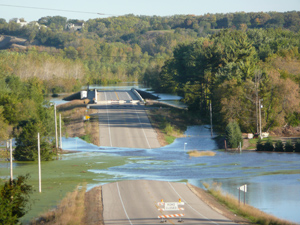 On September 22-23, the largest flood event since 2007, hit southern Minnesota. More than six inches of rain fell over a 5,000 square mile area of southern Minnesota, and rainfall totals of more than eight inches were reported. For many river monitoring locations, stream flow was the highest ever seen during an autumn flood event. Record flooding occurred on the Le Sueur, Minnesota, Straight, Cannon, and Zumbro Rivers. Preliminary analysis indicates that September was the wettest September in Minnesota's modern climate record, with the southern one-third of the State typically recording more than 10 inches of precipitation for the month. USGS crews made many streamflow measurements during September. These measurements ensure that streamflow reported on the Web is accurate and helpful for National Weather Service predictions of flood peaks. The USGS Water Watch and Flood Watch Web sites can be used to track flooding. The USGS WaterAlert service can provide immediate notification via text messages or emails about floods or other flow conditions at USGS gaging stations in Minnesota or other States.
Contact: Dave Lorenz
On September 22-23, the largest flood event since 2007, hit southern Minnesota. More than six inches of rain fell over a 5,000 square mile area of southern Minnesota, and rainfall totals of more than eight inches were reported. For many river monitoring locations, stream flow was the highest ever seen during an autumn flood event. Record flooding occurred on the Le Sueur, Minnesota, Straight, Cannon, and Zumbro Rivers. Preliminary analysis indicates that September was the wettest September in Minnesota's modern climate record, with the southern one-third of the State typically recording more than 10 inches of precipitation for the month. USGS crews made many streamflow measurements during September. These measurements ensure that streamflow reported on the Web is accurate and helpful for National Weather Service predictions of flood peaks. The USGS Water Watch and Flood Watch Web sites can be used to track flooding. The USGS WaterAlert service can provide immediate notification via text messages or emails about floods or other flow conditions at USGS gaging stations in Minnesota or other States.
Contact: Dave Lorenz
New Nutrient Enrichment Effects Report Is Published
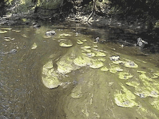 We are pleased to announce the publication of a paper from the Nutrient Enrichment Effects (NEET) topical study that is part of the National Water-Quality Assessment (NAWQA) Program. This paper examines the influence of nutrients and stream habitat on benthic and seston chlorophyll and presents a conceptual model illustrating why streams or regions deviate from expected patterns. The full citation of the paper is: Munn, M., Frey, J., and Tesoriero, A., 2010, The influence of nutrients and physical habitat in regulating algal biomass in agricultural streams: Environmental Management, DOI 10.1007/s00267-010-9435-0. Additional information and publications related to the NAWQA Nutrient Enrichment Effects Team at http://wa.water.usgs.gov/neet/.
 Contact: Kathy Lee
Report Released on Estimates of Peak Streamflows
Estimates of peak-flow magnitudes for 1.5-, 2-, 5-, 10-, 25-, 50-, 100-, and 500-year recurrence intervals are presented for streamflow stations in Minnesota, based on data through water year 2005. The peak-flow frequency information was subsequently used in regression analyses to develop equations relating peak for selected recurrence intervals to various basin and climatic characteristics. Regional regression equations were developed for selected recurrence intervals in each of six regions in Minnesota. The regression equations can be used to estimate peak at ungaged sites. The region of influence regression technique dynamically selects streamflow stations with characteristics similar to a site of interest.Techniques for Estimating the Magnitude and Frequency of Peak on Small Streams in Minnesota Based on Data through Water Year 2005 (SIR 2009-5250) by David L. Lorenz, Chris A. Sanocki, and Matthew J. Kocian
Contact: Dave Lorenz
New report on the quality of the water from public-supply wells
About 105 million people in the United States--more than one-third of the population--receive their drinking water from public water systems that use groundwater as their source. Although the quality of finished drinking water (after treatment and before distribution) from these public water systems is regulated by the U.S. Environmental Protection Agency (USEPA) under the Safe Drinking Water Act, long-term protection and management of groundwater, a vital source of drinking water, requires an understanding of the occurrence of contaminants in untreated source water. Sources of drinking water are vulnerable to a wide variety of human-made and naturally occurring contaminants, including many that are not regulated in drinking water under the Safe Drinking Water Act.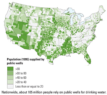 In this study, chemical water-quality conditions were assessed in source (untreated) groundwater from 932 public-supply wells and in source and finished water from a subset of 94 wells. The public wells were located in 41 States and withdraw water from parts of 30 regionally extensive water-supply aquifers, which constitute about one-half of the principal aquifers in the United States. As many as 337 naturally occurring and human-made chemical contaminants were assessed in this study. More than one in five source-water samples from public wells contained one or more contaminants at concentrations greater than human-health benchmarks. Contaminants from natural sources accounted for about three-quarters of contaminant concentrations greater than human-health benchmarks in source-water samples. Contaminants that originate entirely or primarily from human-made sources accounted for about one-quarter of contaminant concentrations that were greater than human-health benchmarks in source-water samples. Human-made contaminants were detected in nearly two-thirds of the samples, predominantly in samples from unconfined aquifers. Mixtures of two or more contaminants at concentrations greater than one-tenth of individual human-health benchmarks were dominated by inorganic contaminants. The most complex mixtures in source water-those with the greatest number of contaminants-were most often detected in samples from unconfined aquifers.
Toccalino, Patricia L.; and Hopple, Jessica A., 2101,Quality of Water from Public-Supply Wells in the United States, 1993-2007, Overview of Major Findings: U. S. Geological Survey Circular 1346, 58 p.
StreamStats Online for Minnesota
StreamStats for Minnesota is a Web-based Geographic Information System that provides users with access to an assortment of analytical tools that are useful for water-resources planning and management, and for engineering design applications, such as the design of bridges. StreamStats allows users to easily obtain streamflow statistics, drainage-basin characteristics, and other information for user-selected sites on streams. StreamStats users can choose locations of interest from an interactive map and obtain information for these locations. If a user selects the location of a U.S. Geological Survey (USGS) data-collection station, the user will be provided with a list of previously published information for the station. If a user selects a location where no data are available (an ungaged site), StreamStats will delineate the drainage-basin boundary, measure basin characteristics and estimate streamflow statistics for the site. These estimates assume natural flow conditions at the site. Streamstats is available at http://water.usgs.gov/osw/streamstats/index.html. The streamflow estimates are based on the USGS Scientific Investigations Report "Techniques for Estimating the Magnitude and Frequency of Peak on Small Streams in Minnesota Based on Data through Water Year 2005" Scientific Investigations Report 2009-5250.Contact: Chris Sanocki
Cooperative Study of Emerging Contaminants in Minnesota Lakes
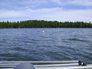 The journal "Total Science of the Environment" has released online access to a USGS-authored journal article documenting emerging contaminants in lakes in Minnesota with evidence of endocrine disruption in fish. The article "Anthropogenic tracers, endocrine disrupting chemicals, and endocrine disruption in Minnesota lakes" presents research results from a joint research project by St. Cloud State University, the Minnesota Pollution Control Agency, and the USGS. USGS participants in the study included Larry Barber and Jeff Writer from the National Research Program and Richard Kiesling from the Minnesota Water Science Center.
 USGS Press Release
Contact: Richard Kiesling
Instant Information Now Available about Minnesota Water Conditions
Now you can receive instant, customized updates via text messages or email about water conditions by subscribing to WaterAlert, a new service from the USGS. Whether you are watching for floods, interested in recreational activities or concerned about the quality of water in your well, WaterAlert allows you to receive daily or hourly updates about current conditions in rivers, lakes and groundwater when they match conditions of concern to you. WaterAlert allows users to receive updates about river , groundwater levels, water temperatures, rainfall, and water quality at any of more than 9,500 sites aross the United States where USGS collects real-time water information. This information is crucial for managing water resources, including during floods, droughts and chemical spills. WaterAlert users start at http://water.usgs.gov/wateralert and select a specific site. Users then select the preferred delivery method (email or text message), whether they want hourly or daily notifications, which data values they are interested in, and the threshold for those values. Users can set the system to alert them when conditions are above a value, below a value, and between or outside of a range.
The USGS Announces Three New Web Data Retrieval Services For Water Data
Web Retrievals for Real-Time Data for Instantaneous Values--Users now have the ability to retrieve USGS real-time instantaneous values for multiple sites with a single request. The service provides data in Extensible Markup Language (XML) and tab-delimited (RDB) file format. Users can select data from multiple sites using a broad set of filters, such as by State, county, watershed and a latitude/longitude box. This new web service can benefit users with programs that download tab-delimited real-time data.Learn more about the service at: http://waterservices.usgs.gov/rest/WOF-IV-Service.html.
Experiment with the service at: http://waterservices.usgs.gov/rest/WOF-IV-Test-Tool.html. Site Information Web Retrievals--Users can request basic information about a specific USGS hydrological site or a range of sites within a given latitude and longitude. These sites can be filtered for active, inactive or real-time only sites. Results can be filtered by site types such as surface water, groundwater or atmospheric. A number of XML-based output formats are provided, including two that ease the display of sites on Google Maps and Google Earth.
Learn more about the service and test it at: http://waterservices.usgs.gov/rest/USGS-Site-Test-Tool.html. Daily Values Web Retrievals-This service has been available for some time, but has moved from "beta" to production status. Daily values are derived by summarizing time-series data for each day for the period of record. Retrievals are available by either REST (Representational State Transfer) or SOAP (Simple Object Access Protocol) retrieval protocols. You can learn more about the service and test it at: http://waterservices.usgs.gov/rest/USGS-DV-Service.html.
Contact: James Fallon
New Journal Article Entitled "Cyanotoxin Mixtures and Taste-and-Odor Compounds in Cyanobacterial Blooms from the Midwestern United States" Published
A journal article on cyanobacterial blooms in the Midwestern United States by Jennifer Graham, Keith Loftin, Mike Meyer, and Andy Ziegler has been published in Environmental Science & Technology. The article also is a headline on the Toxic Substances Hydrology Program Web page. The Web page includes a summary of the study, a link to the journal article, a link to the press release, Frequently Asked Questions, and links to additional information.Contact: Jennifer L. Graham, Kansas Water Science Center
Endocrine Active Chemicals and Biological Responses
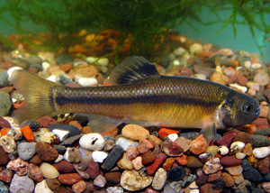 We are pleased to announce a new publication summarizing fourteen years (1994-2008) of research and monitoring of endocrine-active chemicals and biological responses in Minnesota. Endocrine active chemicals have been identified in wastewater-treatment plant effluent and surface waters downstream from discharge of wastewater-treatment plant effluent throughout Minnesota. Although concentrations typically are low, endocrine disruption has been detected in wild fish at sites downstream from wastewater-treatment plant effluent. Endocrine active chemicals and endocrine disruption also have been detected at sites with no wastewater effluent discharge, which indicates that other potential sources exist. We acknowledge important contributions to this report by St. Cloud State University, Minnesota Department of Health, Minnesota Pollution Control Agency, Minnesota Department of Natural Resources, Metropolitan Council Environmental Services, and the University of Minnesota.
 More information on contaminants of emerging concern is available at http://mn.water.usgs.gov/projects/CED/index.html
Contact: Kathy Lee
Most Rivers Across the United States are Altered by Land and Water Management, Leading to Ecological Degradation
A new USGS assessment provides the most geographically extensive analysis to date of streamflow alteration. Findings show that the amount of water flowing in streams and rivers has been significantly altered from land and water management in nearly 90 percent of waters that were assessed in the nationwide USGS study. Flow alterations are a primary contributor to degraded river ecosystems and loss of native species whose survival and reproduction are tightly linked to specific flow conditions. These consequences also can affect water quality, recreational opportunities, and the maintenance of sport fish populations.Flows are altered by a variety of land- and water-management activities, including reservoirs, diversions, subsurface tile drains, groundwater withdrawals, wastewater inputs, and impervious surfaces, such as parking lots, sidewalks and roads. The severity and type of streamflow alteration varies among regions, due to natural landscape features, land practices, degree of development, and water demand. Differences are especially large between arid and wet climates. In wet climates, watershed management is often focused on flood control, which can result in lower maximum and higher minimum . Extremely low flows are the greatest concern in arid climates, in large part due to groundwater withdrawals and high water use for irrigation. For direct access to the journal article in pdf format, please go to: http://water.usgs.gov/nawqa under "Featured headlines."
Contact: Daren Carlisle, 703-648-6890
Wetlands Workshop Held With Tribal Partners
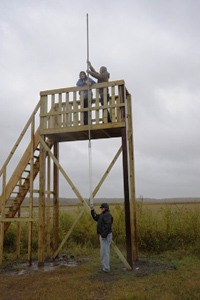 The U.S. Geological Survey, Fond du Lac Band of Lake Superior Chippewa, and Great Lakes Indian Fish & Wildlife Commission held a three-day workshop September 22-24 demonstrating techniques and tools used to characterize wetland vegetation and hydrology and assessing the effects of land-use and climate change on wetlands. Twenty-one scientists from government agencies, universities, and private companies presented technical information, data-collection methods, and research results on wetland topics on the first two days of the workshop. A field trip to the Stoney Brook Watershed was done on the third day of the workshop, demonstrating lake coring, groundwater-level monitoring, surface-water modeling, and other environmental research activities conducted in or for the watershed.
Presentation Summaries
Contact: Perry Jones
Estimated Use of Water in the United States in 2005
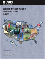 Estimates of water use in the United States indicate that about 410 billion gallons per day (Bgal/d) were withdrawn in 2005 based on a new USGS report. This total is slightly less than the estimate for 2000 and about 5 percent less than total withdrawals in the peak year of 1980. Freshwater withdrawals in 2005 were 349 Bgal/d, or 85 percent of the total freshwater and saline-water withdrawals. Fresh groundwater withdrawals of 79.6 Bgal/day in 2005 were about 5 percent less than in 2000, and fresh surface-water withdrawals of 270 Bgal/day were about the same as in 2000. Withdrawals for thermoelectric-power generation and irrigation, the two largest uses of water, have stabilized or decreased since 1980. Withdrawals for public-supply and domestic uses have increased steadily since estimates began. USGS Circular 1344.
Contact: Jim Stark