New publications from the USGS in Minnesota
Groundwater pumping and precipitation affect lake levels in Northeast Metropolitan Area
It has long been recognized that lake and river levels rise and fall in response to increasing or decreasing precipitation. However, understanding the effect of groundwater pumping on surface water levels is a much more challenging problem given the complexities of groundwater and surface-water interactions. The USGS recently completed a multi-year study of groundwater and surface-water interactions in the Northeast Metropolitan Area of the Twin Cities, a region with numerous lakes and considerable urbanization.
The latest report from this study describes the development of a new model that incorporates the best available geologic data in the region to examine lake-level changes in the context of climatic data and pumping. Results of the modeling study indicate that groundwater withdrawals are important for some of the lakes in the Northeast Metro, in particular deeper lakes in more urban parts of the study area. More details are available in a recent technical announcement.
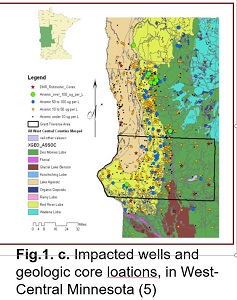
Sources and Mechanisms of Release of Arsenic in Drinking Water Aquifers
Arsenic contamination affects groundwater systems across the globe. Arsenic is released from aquifer sediments to groundwater when biogeochemical conditions in aquifers fluctuate. A new paper examines solid-phase sources and geochemical mechanisms of arsenic release in aquifers of the Des Moines Lobe glacial advance, particularly at the aquifer-aquitard interface. A microprobe X-ray absorption spectroscopy approach was applied to drill core samples to identify the solid-phase speciation of arsenic in aquifer, aquitard, and aquifer-aquitard interface sediments. In two of the three locations studied, glacial sediment forming the aquitard is the source of arsenic to the aquifer sediments. The findings show that glacial sediments at the interface between aquifer and aquitard are geochemically active zones for arsenic. The diversity of arsenic release mechanisms is consistent with the geographic heterogeneity observed in the distribution of elevated-arsenic wells.
University of Minnesota doctoral student Sarah Nicholas was lead author on the paper, which included two authors from the USGS Minnesota office, Melinda Erickson and Laurel Woodruff. The paper was published in Geochimica et Cosmochimica Acta. Contacts: Brandy Toner, (toner@umn.edu), and Melinda Erickson (merickso@usgs.gov)
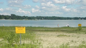
Blue-green Algae and Fish Habitat Suitability at Two Minnesota Lakes Dominated by Agricultural Land-use
Predictive water-quality models are useful to better manage and mitigate loss of fish habitat due to summer blue-green algal blooms. The USGS, in collaboration with the Minnesota Department of Natural Resources, developed CE-QUAL-W2 water-quality models for two Minnesota sentinel lakes — Madison Lake and Pearl Lake — to assess algal community dynamics, in particular the timing of blue-green algal blooms, as well as quantify fish habitat suitability for agricultural land-use dominated lakes. The new report presented model simulations that provide potential explanations for persistently large total phosphorus concentrations in Madison Lake, key differences in nutrient concentrations between the two lakes, and summer blue-green algal bloom persistence. Fish habitat suitability simulations for cool-water and warm-water fish indicated that, in general, both lakes contained a large proportion of good-growth habitat and a sustained period of optimal growth habitat in the summer, without any periods when habitats were lethal due to low oxygen and/or high temperature. Contact: Erik Smith, (easmith@usgs.gov).
Microplastics in the St. Croix and Mississippi Rivers
Plastic fragments, films, beads, and fibers
1 millimeter of a microscope's viewing area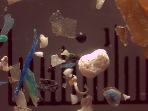 |
Microplastics, tiny particles of plastic that come from sources such as soaps, synthetic clothing, and textiles, are an emerging concern in the aquatic environment. Recent research, led by the USGS's Austin Baldwin, found plastics in every water, sediment, fish, and mussel sample collected as part of this study. This work is highlighted in a National Park Service Resource Brief.
New approach to P loading in the Red River
A new paper by Karen Ryberg, USGS-North Dakota, uses a structural equation modeling approach to examine phosphorus loads in the Red River of the North. The structural equation model representing loads at six sites in the basin shows that climate and agricultural practices explain almost 60% of the annual total phosphorus load in the Red River of the North basin. The modeling process and the unexplained variance highlight the need for better ancillary long-term data for causal assessments. Contact: Karen Ryberg (kryberg@usgs.gov)
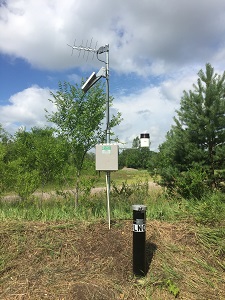
Continuous, Real-time Climate Response Network Wells Instrumented
Tim Cowdery and Andrew Berg recently installed equipment to continuously monitor groundwater level, groundwater temperature, and precipitation at monitoring wells in Big Lake, MN and Windom, MN. These data are transmitted in real-time and are available at USGS 435239095074801 and USGS 452012093412701. These sites are now part of the USGS Climate-Response Network, a network of wells used to monitor the effects of drought and climate variability on groundwater levels. In addition to examining trends driven by climate variability, high-quality groundwater level records that are precise to one-hundredth of a foot are useful for examining important hydrologic fluxes such as groundwater recharge.
Staff Notes
Welcome Alyssa Witt
Alyssa Witt |
Alyssa Witt has completed a dual-major M.S. in Geology and Environmental Science at Iowa State University. Alyssa was a student employee for our office while completing her M.S. thesis research on recharge rates in confined aquifers in central and northeastern Minnesota. Upon graduation, Alyssa has been converted from a student employee to a full-time hydrologist at USGS. She plans to continue working on water sustainability and aquifer contamination issues. Alyssa is continuing work on our confined aquifer study, as well as working on groundwater issues for American Indian communities within Minnesota.
Welcome Erin Coenen
Erin Coenen |
Erin received her B.S. degree with a major in Environmental Sciences, Policy, and Management and a minor in Water Sciences from the University of Minnesota - Twin Cities in May 2017. Erin started as a student employee with the USGS in June of 2014. Upon graduation, Erin was converted from a student employee to a full-time hydrologic technician at USGS. Erin will serve as a field crew lead for the Sediment Program, and she will continue to support projects in other focus areas within the Minnesota Water Science Center.
Erik Smith--Civil Servant of the Year
Erik Smith |
Erik Smith was named our 2017 Civil Servant of the Year. In addition to Erik's consistent high-level job performance, Erik represents the USGS well outside the office. For several years, Erik led volunteers at the Irondale High School STEAM career fair, participated on the State's Drainage Management Team, and other outside meetings. Erik participates on our Employee Recognition Team, and relates to co-workers regardless of their team, grade, or job classification. His humor helps to raise his co-workers' spirits.
|
Significant National publications
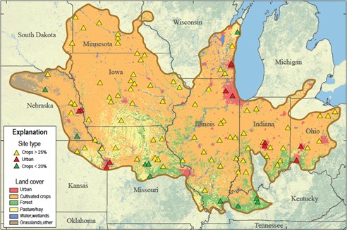
Pesticides in Midwestern Streams
More than 180 pesticides and their byproducts were detected in small streams throughout 11 Midwestern states, some at concentrations likely to harm aquatic insects, according to a new report by the U.S. Geological Survey.
On average, 52 pesticide compounds were detected in each stream. At least one pesticide in at least half of the 100 streams sampled exceeded a threshold predicted to cause harm to aquatic insects and other stream organisms. Pesticides were not measured at levels predicted to be toxic to fish in most streams.
Whereas numerous pesticides were detected at low levels, only a few—atrazine, acetochlor, metolachlor, imidacloprid, fipronil, and organophosphate insecticides—were predicted to be major contributors to toxicity. The first three are widely used agricultural herbicides, and the latter three are insecticides used in both residential and agricultural settings.
This is one of the most extensive assessments of pesticides in streams to date: 1,200 samples were collected at 100 Midwest streams over a 12-week period during the 2013 growing season and analyzed for 228 pesticide compounds. This study is one component in the first in a series of five USGS regional stream quality assessments. Contact: Lisa Nowell, (lhnowell@usgs.gov)
New Tools for Sediment Fingerprinting
Fine sediment is a major pollutant in aquatic ecosystems worldwide, which degrades systems through light attenuation, burial, and transport of sorbed contaminants. Excess sediment also affects reservoir storage capacity, channel conveyance, and drinking water. Additionally, sediment is commonly associated with many of the U.S. Environmental Protection Agency's top causes of impairment of U.S. waters on the 303(d) list. Effectively managing these sediment problems necessitates developing approaches for identifying the significant sources of sediment. The USGS recently announced three publications on sediment source assessments and sediment budgets that highlight the sediment fingerprinting approach and are now available online:
- A Manual to Identify Sources of Fluvial Sediment. Prepared in cooperation with the USGS Chesapeake Bay Program and EPA, this manual highlights approaches to construct a sediment budget, including the sediment fingerprinting approach.
- The Sediment Source Assessment Tool (Sed_SAT) Sed_SAT is a program to assist those using the sediment fingerprinting approach to apportion the source of watershed-derived fine-grained sediment. The program also was prepared in cooperation with the USGS Chesapeake Bay Program and EPA.
- Accompanying Sed_SAT is a Users' Guide, Determining the Sources of Fine-Grained Sediment Using the Sediment Source Assessment Tool (Sed_SAT).
In addition to researchers from the USGS's Maryland and Wisconsin offices, Dave Lorenz (retired from USGS Minnesota office) co-authored the Sed_SAT program and user's guide. We have a very active fluvial sediment program in Minnesota, and are interested in applying these new tools to solve sediment-source questions in Minnesota's rivers.
In related news, a new Techniques and Methods report published earlier this year details continuous-flow centrifugation methods that may aid sediment fingerprinting studies.
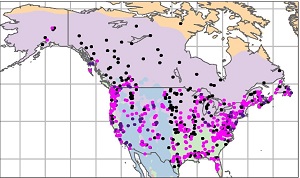
Study Links Major Floods in North America and Europe to Multi-Decade Ocean Patterns
The number of major floods in natural rivers across Europe and North America has not increased overall during the past 80 years, a recent study has concluded. Instead researchers found that the occurrence of major flooding in North America and Europe often varies with North Atlantic Ocean temperature patterns. This new study is by far the largest scale analysis of major flood trends for watersheds that are minimally disturbed by human activities. It provides vital information to help understand the most common and widespread of all natural hazards on Earth—a hazard that causes substantial losses of life and property.
"This study is unique in that it examined trends in major floods only—those with 25-year or longer return periods—that typically cause the most damage to infrastructure," said USGS research hydrologist Glenn Hodgkins, who led an international team of scientists in the study. "We examined historical streamflow data from more than 1,200 diverse but minimally altered watersheds across two continents."
The study included 537 stream gages from the USGS's Hydro-Climatic Data Network. Watersheds that were subject to confounding human influences on flooding, such as urbanization and reservoir regulation, were screened out of this study. Three Minnesota sites were included in the analysis (Wild Rice River at Twin Valley, Middle River at Argyle, and Little Fork River at Littlefork). See the News Release for more detail and a link to the paper.
National report on water quality trends in streams
Scientific Investigations Report
2017-5006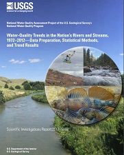 |
Since passage of the Clean Water Act in 1972, Federal, State, and local governments have invested billions of dollars to reduce pollution entering rivers and streams. To understand the return on these investments and to effectively manage and protect the Nation's water resources in the future, we need to know how and why water quality has been changing over time. As part of the U.S. Geological Survey's National Water-Quality Program, data from the U.S. Geological Survey, along with multiple other Federal, State, Tribal, regional, and local agencies, have been used to support the most comprehensive assessment conducted to date of surface-water-quality trends in the United States. The new report details methods and nearly 12,000 individual trend results. Contact: Lori Sprague (lsprague@usgs.gov)
NAGT Interns
Our office welcomed a total of five National Association of Geoscience Teachers interns this summer. NAGT Interns are top students from their geology field camps, as identified by their professors, and include both recent graduates, and returning college seniors.
Trevor Dusza
Trevor Dusza |
Trevor worked this summer on a project compiling U.S. Forest Service water-quality data for northeastern Minnesota. Trevor also participated in several field trips, focusing on surface water-groundwater interactions in northeastern MN, and geophysical surveys of lake sediments in reservoirs and the St. Louis River estuary. Trevor returns to the University of Wyoming this fall to complete a B.S. in Geology, with a minor in Geographic Information Systems.
Sarah Ostertag
Sarah Ostertag |
Sarah earned a B.S. in Geology, with a minor in International Relations, from Wheaton College in Illinois. In addition to field work at the USGS's Bemidji Crude Oil research site, Sarah has compiled information for a national analysis and map of petroleum spill sites that could affect water resources and public health. Sarah expanded her GIS skills greatly on this project. Sarah plans to work for one or two years, before returning to graduate school most likely in geology. She also has an interest in public policy related to water and mineral resources.
Schuyler Robinson
Schuyler Robinson |
Schuyler earned a B.S. in Geology from Brigham Young University-Idaho. Schuyler had a "crash course" in groundwater modeling this summer, developing the initial MODFLOW groundwater model for Litchfield confining units study site. Schuyler plans to continue with hydrology and groundwater modeling as he pursues an M.S. in Geology at BYU's main campus in Provo, UT starting this fall. After graduate school, Schuyler is interested in both petroleum geology and hydrology.
Trent Sherman
Trent Sherman |
Trent earned a B.S. in Geology from California State University - Fresno. Trent worked for the Sediment Program at the Minnesota Water Science Center from April through June of 2017. Trent recently was hired as an Engineering Geologist with the California Department of Water Resources, where he will work in support of California's Sustainable Groundwater Act. Trent may pursue graduate studies in fluvial geomorphology in the future.
William Otto
William Otto |
William earned a B.S. in Earth Sciences with Geology Option from Oregon State University. William is working within a multi-institution research project to assess landslide hazards in Minnesota. William currently is analyzing high-resolution data to identify topographic change from airborne lidar surveys taken before and after the devastating 2012 Duluth, MN floods. William also is working on landslide and earthquake hazard research in California and will participate in field work in California in August and September. William is interested in process geomorphology and remote sensing and plans to attend graduate school in fall 2018.
We greatly enjoyed having each of these interns here this summer. Our interns are always a great source of enthusiasm and talent during the summer field season, and make valued contributions to earth science.
|