Minnesota Water Science Center Newsletter Fall 2015 |
U.S. Department of Interior U.S. Geological Survey Minnesota Water Science Center 2280 Woodale Drive Mounds View, MN 55112 http://mn.water.usgs.gov |
||||||||
Dave Lorenz is retiring
Please join us, at Como Park Golf Club, to celebrate with Dave and Vicky. January 22, 2016 from 5:00 to 10:00 p.m. 1431 Lexington Parkway North St. Paul, MN 55103
A light dinner will be served at 6:00 pm
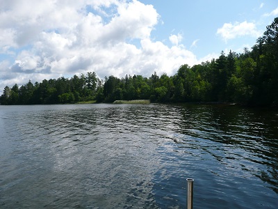
Please send a check, for $20 per person, by January 15 to: New Algal Bloom Study in Voyageurs National Park
Christensen, V.G., Maki, R.P., and Kiesling, R.L., 2011, Relation of nutrient concentrations, nutrient loading, and algal production to changes in water levels in Kabetogama Lake, Voyageurs National Park, northern Minnesota, 2008–09: U.S. Geological Survey Scientific Investigations Report 2011–5096, 50 p. Christensen, V.G., Maki, R.P., and Kiesling, R.L., 2013, Evaluation of internal loading and water level changes: implications for phosphorus, algal production, and nuisance blooms in Kabetogama Lake, Voyageurs National Park, Minnesota: Lake and Reservoir Management, 2 (3) 202-215. For more information on the study, contact Victoria Christensen, [email protected] Using Chemistry to Track Lake Sturgeon Life Histories
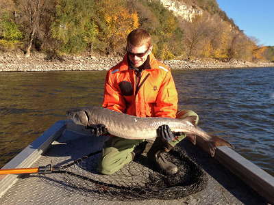
To better understand movement patterns of lake sturgeon in Minnesota’s waters, the USGS Minnesota Water Science Center is conducting two studies that use water and pectoral fin ray chemistry to track migratory histories of this unique fish. Pectoral fin rays are bony structures containing annual rings that can be counted to determine the age of sampled fish. Fin rays can be collected non-lethally during fishery surveys. Composed mostly of calcium, fin rays include traces of other metals such as strontium and barium. By examining the relations between trace metals in fin rays and the chemistry of waters throughout large drainage basins, we hope to determine the migratory history of the fish (Phelps and others, 2012). The first study aims to better understand the connectivity of lake sturgeon populations in the St. Croix and Mississippi Rivers. Understanding movement of sturgeon between these two river basins will provide important insights into how sturgeon populations may be affected by proposed invasive carp barriers. The second study is being conducted in the five lakes and six major tributaries of Namakan Reservoir in northern Minnesota (USA) and southern Ontario (Canada). The goal of the study is to determine the proportion of the sturgeon population that can be attributed to each spawning tributary in order to assess the potential effects that proposed hydropower operations on the Namakan River in Ontario may have on the sturgeon population. Data collection for both studies is complete and data analysis will begin in 2016. Both studies are funded by National Park Service-USGS Partnerships. Collaborators include the St. Croix National Scenic Riverway, Mississippi National River and Recreation Area, USGS Upper Midwest Environmental Sciences Center, Minnesota Department of Natural Resources, Missouri Department of Conservation, Voyageurs National Park, and South Dakota State University. Auer, N.A., 1996, Importance of habitat and migration to sturgeons with emphasis on lake sturgeon: Canadian Journal of Fisheries and and Aquatic Sciences, v. 53, no. 1, p. 152-160. Phelps, Q.E., Whitledge, G.W., Tripp, S.J., Smith, K.T., Garvey, J.E., Herzog, D.P., Ostendorf, D.E., Ridings, J.W., Crites, J.W., Hrabik, R.A., Doyle, W.J., and Hill, T.D., 2012, Identifying river of origin for age-0 Scaphirhynchus sturgeons in the Missouri and Mississippi rivers using fin ray microchemistry: Canadian Journal of Fisheries and Aquatic Sciences, v. 69, no. 5, p. 930-941. Rochard, E., Castelnaud, G., and Lepage, M., 1990, Sturgeons (Pisces: Acipenseridae); threats and prospects: Journal of Fish Biology, v. 37, suppl. A., p. 123-132. For more information on these studies, contact Jeff Ziegeweid, [email protected] U.S. Rivers Show Historical Increases in Nitrate with Few Signs of Improvement in Recent Decades
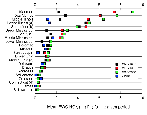
Stets, E.G., Kelly, V.J., and Crawford, C.G., 2015. Regional and temporal differences in nitrate trends discerned from long-term water quality monitoring data: Journal of the American Water Resources Association (JAWRA), vol. 51 (5), p. 1394-1407. DOI: 10.1111/1752-1688.12321. For more information contact Ted Stets, [email protected] or Lori Sprague, [email protected]. |
John Bumgarner--Moving on to the Land of Enchantment
Kathy Lee, New Deputy Director of the Toxic Substances Hydrology Program
Kathy started with the USGS in Kansas in 1992, and has been in the Minnesota office since 1995. In her 20-year tenure here, Kathy has conducted numerous studies of the sources, fate, and biological effects of contaminants in Minnesota's waters. She built a highly collaborative research program, working with other agencies, university researchers, and researchers across the USGS. Kathy continues to live in Grand Rapids, but now reports to USGS Headquarters in Reston, VA. Kathy's scientific leadership will serve her well in this new position and she will be missed in the USGS Minnesota Water Science Center’s day-to-day operations. Assessing the Water Quality and Oxy-thermal Habitat Dynamics of Lake St. CroixThe St. Croix River Basin has experienced substantial land-use changes since the beginning of European settlement. These land-use changes within the St. Croix River Basin, in particular the lower 25 miles that make up Lake St. Croix, have increased nutrient loads and degraded water quality in Lake St. Croix. In 2008, Lake St. Croix was designated as an impaired water body by Minnesota and Wisconsin for excess phosphorus (Minnesota Pollution Control Agency, 2013). Efforts by National Park Service (NPS) Centennial Strategies Initiative and other multi-agency efforts to improve water quality have led to reduced total phosphorus concentrations. However, despite decreasing phosphorus loads, algal biomass measured as chlorophyll in Lake St. Croix have not decreased as expected (Lafrancois and others 2009; MPCA 2013). As part of the NPS Centennial Strategies Initiative, the USGS Minnesota Water Science Center, in cooperation with the NPS, is developing a predictive water-quality model to assess the water quality and habitat dynamics of Lake St. Croix. Part of the goal was to evaluate the potential underlying causes of the systemic nature of the algal blooms. Both hydrodynamics and water-quality characteristics will be simulated using the CE-QUAL-W2 model. The CE-QUAL-W2 model addresses the interaction between nutrient cycling, primary production, and trophic dynamics to predict responses in the distribution of temperature and oxygen in lakes. This study also will include modeling different load reduction scenarios to evaluate the effects on water quality, fish habitat, and the magnitude and timing of algal blooms. For more information contact Erik Smith at [email protected] or Richard Kiesling at [email protected]. Lafrancois, B. M., S. Magdalene, and D. K. Johnson. 2009. Recent water quality trends and a comparison to sediment-core records for two riverine lakes of the upper Mississippi River basin: Lake St. Croix and Lake Pepin. Journal of Paleolimnology 41(4):603–622. doi 10.1007/s10933-008-9294-3. Minnesota Pollution Control Agency, 2013, Implementation plan for the Lake St. Croix nutrient total maximum daily load, at http://www.pca.state.mn.us/index.php/view-document.html?gid=18736 USGS Testing a Novel Technology for Measuring Arsenic in Minnesota Groundwater Samples
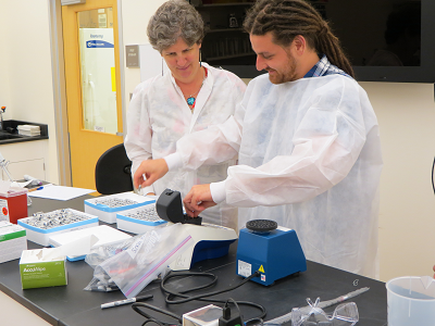
In July 2015, USGS established a collaboration with the German Helmholtz Center for Environmental Research , which will augment the current arsenic research study. The purpose of the collaboration is to test the potential application of the Helmholz Center’s ARSOlux biosensor as a novel, quick-turnaround test of arsenic concentrations in Minnesota well water used for drinking water. The new arsenic test method is less expensive than traditional methods and can give semi-qualitative results the same day. Biosensor results will be compared to analyses completed by the MDH Public Health Laboratory to gauge comparability to current methods.
The arsenic biosensor is a promising technology for reliable, cost-effective, and rapid field applications so that researchers and well owners can more quickly assess health risks associated with high arsenic concentrations in drinking water wells. This study would be the first application of the ARSOlux biosensors in the United States. For more information about the current arsenic research project or general questions about arsenic in Minnesota groundwater, contact Dr. Mindy Erickson, [email protected]. New USGS Study Indicates that Rivers had a Natural Potential to Remove Nitrogen from the WaterA new article published in the journal Nature Geoscience describes the work of USGS scientists and collaborators from the University of Texas at Austin working throughout the Mississippi River Basin. The article establishes the river’s own potential to decrease its load of nitrate and identified how certain basic river management practices could increase that potential. "Increasing nitrogen concentrations, mostly due to the runoff of agricultural fertilizers, in the world's major rivers have led to over-fertilization of waters downstream, diminishing their commercial and recreational values," said William Werkheiser, USGS Associate Director for Water. "Understanding the natural potential of rivers themselves to remove nitrogen from the water, and boosting that potential, is a promising avenue to help mitigate the problem." Beneath all streams and rivers is a shallow layer of sediment that is permeated by water exchange across the sediment surface. This thin region in the sediment beneath and to the side of the stream is referred to by scientists as the "hyporheic" zone, from Greek words meaning "under the flow." "We’ve found in previous studies,” said Jesus Gomez-Velez, lead author of the article "that the flow of stream water through this thin zone of sediment enhances chemical reactions by microbes that perform denitrification, a reaction that removes nitrogen from the aquatic system by converting it to nitrogen gas." A USGS post-doctoral scientist at the time of the study, Gomez-Velez is now an assistant professor at the New Mexico Institute of Mining and Technology. The research team determined that throughout the Mississippi River network exchange between sediments directly beneath streams and rivers (vertical exchange) has denitrification potential that far exceeds exchange with bank sediments (lateral exchange). "Rivers with more vertical exchange are more efficient at denitrification, as long as the contact time with sediment is matched with a reaction time of several hours," observed co-author Jud Harvey, the USGS team leader for the study. The study findings indicate that managing rivers to help avoid the sealing of streambeds with fine sediments, which decreases hyporheic flow, would help exploit the valuable natural capability of rivers to improve their own water quality. Other river management and restoration practices that protect permeable river bedforms could also boost efficiency, such as reducing fine sediment runoff to rivers. However, typical river channel restoration strategies that realign channels to increase meandering would not be as effective because a comparatively small amount of water and river nitrate are processed through river banks compared with river beds. Although not yet tested in the model, allowing natural flooding over river banks onto floodplains may also be an effective means of processing large amounts of river water to remove nitrogen before it reaches sensitive coastal waters. Gomez-Velez, J.D., J.W. Harvey, M.B. Cardenas, and B. Kiel, 2015, "Denitrification in the Mississippi river network controlled by flow through river bedforms, Nature Geoscience, doi: 10.1038/ngeo2567. | ||||||||
| |||||||||
|
*Any use of trade, firm or product names does not imply endorsement by the U.S. Government. | |||||||||