Laurel Woodruff Honored by Institute on Lake Superior Geology
Laurel Woodruff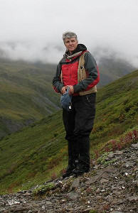 |
Research Geologist Laurel Woodruff (Eastern Mineral and Environmental Resources Science Center, co-located in our Mounds View office) was awarded the Sam Goldich Medal at the 60th Annual Meeting of the Institute on Lake Superior Geology in Hibbing, Minnesota. The award recognizes Laurel’s career-long contributions to understanding the geology of the Lake Superior region as well as service to the Institute.
Link: 2014 Goldich Medal citation
Products and Reports
New Report on Flood-Inundation Maps for the Mississippi River in St. Paul
A new report by Christiana Czuba and others describes the development of digital flood-inundation maps for a 6.3-mile reach of the Mississippi River in St. Paul. These inundation maps were developed through a multi-agency effort by the USGS in cooperation with the U.S. Army Corps of Engineers and the National Weather Service (NWS). The inundation maps depict estimates of the areal extent and depth of flooding corresponding to selected water levels (stages) at the USGS streamgage at the Mississippi River at St. Paul. The NWS forecasted peak-stage information at the streamgage may be used in conjunction with the maps developed in this study to show predicted areas of flood inundation. These maps, along with information regarding current stage at the USGS streamgage and forecasted stages from the NWS, provide enhanced flood warning and visualization of the potential effects of a forecasted flood for the city of St. Paul and its residents. The maps also can aid in emergency management planning and response activities, such as evacuations and road closures, as well as post-flood recovery efforts.
Full Report
Direct links to the flood-inundation maps for the Mississippi River at St. Paul:
USGS: http://wim.usgs.gov/fimi/?siteno=05331000
NWS: http://water.weather.gov/ahps2/inundation/inundation_google.php?gage=STPM5
The maps also can be accessed through the USGS Flood Inundation Mapping Science Web site at
http://water.usgs.gov/osw/flood_inundation/ and the NWS Advanced Hydrologic Prediction Service site at http://water.weather.gov/ahps/inundation.php.
Water Quality and Algal Community Dynamics of Three Minnesota Sentinel Lakes
A new report by Erik Smith and others describes the development of predictive water-quality models to assess water quality and habitat dynamics for three “super-sentinel” deep-water lakes in Minnesota. Currently in Minnesota, a large-scale effort by the Minnesota Department of Natural Resources (MNDNR) called "Sustaining Lakes in a Changing Environment (SLICE)" monitors a network of lakes as sentinels of environmental change. The SLICE program focuses on monitoring basic watershed, water quality, habitat, and fish indicators for 24 Minnesota sentinel lakes across a gradient of ecoregions, depths, and nutrient levels with the aim to develop diagnostic indicators of lake ecosystem health. As part of this effort, the USGS, in cooperation with the MNDNR, developed predictive water-quality models to assess water quality and habitat dynamics for three “super-sentinel” deep-water lakes in Minnesota. The three lakes (Lake Carlos in Douglas County, Elk Lake in Clearwater County, and Trout Lake in Cook County) were assessed under recent (2010–11) meteorological and water quality conditions using the mechanistic, hydrodynamic CE-QUAL-W2 model.
The CE-QUAL-W2 models successfully addressed the interaction between nutrient cycling, primary production, and trophic dynamics to predict responses in the distribution of coldwater fish habitat based on temperature and oxygen profiles in lakes. The models successfully tracked the seasonal development of mid-water column (known as meta-limnetic) low oxygen “bottlenecks” in Lake Carlos fish habitat as well as mid-water column algae biomass peaks that develop in Elk Lake in early summer. The models have been used to "hindcast" the development of historical habitat bottlenecks in Lake Carlos using historical meteorological data for years when coldwater fish kills were observed by MNDNR field personnel. For more information about the USGS Sentinel Lakes program, or to participate in monitoring for responses to climate change, please contact Richard Kiesling ([email protected]), Minnesota Water Science Center Limnology Specialist and Project Chief.
Full Report
Soil Geochemistry Survey of the Nation
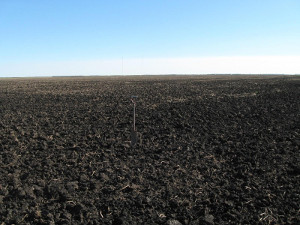
The U.S. Geological Survey has completed a low-density (1 site per 1,600 square kilometers, 4,857 sites) geochemical and mineralogical survey of soils in the conterminous United States as part of the North American Soil Geochemical Landscapes Project. The sampling protocol for the national-scale survey included, at each site, a sample from a depth of 0 to 5 centimeters, a composite of the soil A horizon, and a deeper sample from the soil C horizon or, if the top of the C horizon was at a depth greater than 1 meter, a sample from a depth of approximately 80-100 centimeters. The <2-millimeter fraction of each sample was analyzed for a suite of 45 major and trace elements by methods that yield the total or near-total elemental content. The major mineralogical components in the samples from the soil A and C horizons were determined by a quantitative X-ray diffraction method using Rietveld refinement. Sampling in the conterminous United States was completed in 2010, with chemical and mineralogical analyses completed in May 2013.These data provide an estimate of the abundance and spatial distribution of chemical elements and minerals in soils of the conterminous United States and represents a baseline for soil geochemistry and mineralogy against which future changes may be recognized and quantified. All geochemical and mineralogical data were released in 2013 as USGS Data Series 801. A set of geochemical and mineralogical maps created from the interpolated point data have been released as USGS Open-File Report 1082 and as an interactive website.
Contact: Laurel Woodruff ([email protected])
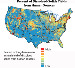
New Report on Dissolved Solids in the Nation's Streams
This new report provides science-based information on where dissolved solids concentrations are elevated and on the dominant sources contributing to these conditions. Maps of concentrations, yields, and loads of dissolved solids in streams are available on the online, interactive decision support tool. The online tool can also be used to evaluate dissolved-solids loads to any user-selected watershed outlet or to predict how changes in selected sources of dissolved solids within a selected watershed may change loadings to the watershed outlet.
Contact: David Anning ([email protected])
Press Release
Full Report
Mercury Trends in Northern Minnesota
Mark Brigham in Voyageurs National Park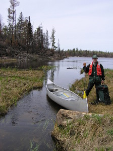 |
A new journal article by Mark Brigham and others describes mercury trends in northern Minnesota, including two National Atmospheric Deposition Program monitoring sites and four remote lakes in Voyageurs National Park. Wet deposition of mercury decreased considerably in northern Minnesota from 1998 to 2012. Wet deposition of sulfate and hydrogen ion—also important in the aquatic mercury cycle—also decreased during the same period. Consistent with decreases in these atmospheric pollutants, two of four study lakes in Voyageurs National Park also showed considerable decreases in methylmercury in water and year-old perch. However, in a third lake, methylmercury levels increased in water and fish; a fourth lake showed no consistent trend. The research was featured in several news stories, including this story in MinnPost.
Contact: Mark Brigham [email protected])
Full Report
Continuous Nitrate Monitoring
The USGS continues to explore the many uses of continuous nitrate monitoring in our water resources.
Read more about the many examples across the Nation and relevance to drinking water supplies, wastewater, land-management practices, and tracking nitrogen loads to key estuaries. http://water.usgs.gov/coop/features/real-time.nitrate.summary.pdf
Impact of Climate Variability on Runoff in the North-Central United States
A new journal article by Karen Ryberg and others explores the impact of climate variability on runoff in the north-central United States. Large changes in runoff in the north-central United States have occurred during the past century, with larger floods and increases in runoff tending to occur from the 1970s to the present. The attribution of these changes is a subject of much interest. Long-term precipitation, temperature, and streamflow records were used to compare changes in precipitation and potential evapotranspiration (PET) to changes in runoff within 25 stream basins. The basins studied were organized into four groups, each one representing basins similar in topography, climate, and historical patterns of runoff. Precipitation, PET, and runoff data were adjusted for near-decadal scale variability to examine longer-term changes. A nonlinear water-balance analysis shows that changes in precipitation and PET explain most of the multidecadal spatial/temporal variability of runoff and flood magnitudes, with precipitation being the dominant driver. Historical changes in climate and runoff in the region appear to be more consistent with complex transient shifts in seasonal climatic conditions than with gradual climate change. A portion of the unexplained variability likely stems from land-use change.
Full Report
New Report Assesses Gaps in Streamflow Information
A new report by Julie Kiang and others evaluates how well the USGS streamgage network meets needs for streamflow information by assessing the ability of the network to produce various streamflow statistics at locations that have streamgages (gaged) and locations that do not have streamgages (ungaged). The report analyzes where there are gaps in the network of gaged locations, how accurately useful statistics can be calculated with a given length of record, and whether the current network allows for estimation of these statistics at ungaged locations. The results of the report indicate that there is variability across the Nation’s streamflow data-collection network in terms of the spatial and temporal coverage of streamgages. In general, the eastern United States has better coverage than the western United States. The arid southwestern United States, Alaska, and Hawaii were observed to have the poorest spatial coverage, using the dataset assembled for this study. With the exception of Hawaii, these areas also tended to have short streamflow records. Differences in hydrology lead to differences in the uncertainty of statistics calculated in different regions of the country.
Full Report
New Findings on the Effects of Urbanization on Streams Help Direct Protection Actions
The USGS National Water-Quality Assessment (NAWQA) Program recently released results of a study to better understand the effects of urban development on streams and aquatic life in different regions of the country. The report describes differences observed in metropolitan areas, the reasons for these differences, and the implications for stream protection and restoration. The report also describes a new innovative tool that can assist decision makers at all levels of government in evaluating how improvements to one or more stream conditions can increase the likelihood of reaching stream goals.
Each American effectively occupies about 20 percent more developed land for housing, schools, shopping, roads, etc., than they did only 20 years ago. To address the challenge, many local governments, businesses, and citizen coalitions are seeking cost-effective approaches to protect and restore urban streams. At the same time, the U.S. Environmental Protection Agency (EPA) is promoting the use of “green infrastructure” and developing rules to reduce urban runoff. In addition, the Department of Interior, U.S. Department of Agriculture, and EPA along with seven other Federal agencies support an interagency Urban Waters Federal Partnership actively working to restore urban streams in 10 cities across the country. Results of this nationwide study and details about the effects of urbanization on the nine metropolitan areas can be found in a new USGS publication titled, "Effects of urban development on stream ecosystems in nine metropolitan study areas across the United States." Management strategies used throughout the United States to reduce the effects of urban development on stream ecosystems are described in a new USGS report written in partnership with the Center for Watershed Protection in Maryland titled, "Strategies for Managing the Effects of Urban Development on Streams."
New Report on the Ecological Health of the Nation's Streams
A new report describes the results of a national analysis of data on the roles of hydrology, and water and sediment chemistry on the health of aquatic communities in streams that was made possible by the hard work of the many ecologists and hydrologists in USGS Science Centers and headquarters that worked on the NAWQA program over the last 20 years. Links to the reports, fact sheet, press release, FAQs, and other information are posted on the project website.
Contact: Daren Carlisle ([email protected])
New USGS Web Page About Neuroactive Pharmaceuticals in Minnesota Rivers
A team of scientists from the USGS and the University of Colorado measured seven neuroactive pharmaceutical compounds in treated wastewater and downstream receiving waters at 24 sites across Minnesota. The analysis of samples collected upstream and downstream from wastewater treatment plants indicated that wastewater treatment plants were the major source of these chemicals. These neuroactive pharmaceuticals include antidepressants, anti-seizure compounds, and mood stabilizers. The seven compounds (bupropion, carbamazepine, citalopram, fluoxetine, gabapentin, lamotrigine, and venlafaxine) were detected at concentrations ranging from tens of parts per trillion to parts per billion. Metabolites (byproducts of biochemical transformation) of these compounds also were measured, and metabolites of bupropion, carbamazepine, and venlafaxine were measured commonly, often at comparable concentrations to their parent compounds. Metabolite to parent ratios were used to evaluate transformations among the various sites, and the ratios in wastewater were much lower than those reported for urine from human patients, indicating that the metabolites are relatively more labile than the parent compounds in the wastewater treatment plants and streams. Results from this study provide a statewide benchmark for the occurrence of antidepressants, which are potential environmental contaminants of concern, and indicate that further understanding of the environmental fate and impacts of these compounds is warranted. The research was supported by the USGS Toxic Substances Hydrology Program and the Minnesota Pollution Control Agency.
http://toxics.usgs.gov/highlights/neuroactive.html
|
Employee Recognition: John Bumgarner - New Center Investigations Chief
John Bumgarner |
The Minnesota Water Science Center (Center) welcomes Johnathan Bumgarner, P.G. (Texas), as the Center’s Investigations Chief. John earned B.S. and M.S. degrees in Geological Sciences from the University of Texas at Austin and is a licensed Professional Geologist in the State of Texas. Prior to joining the USGS in 2010, John was an environmental consultant where his major projects included groundwater assessments, vadose zone contaminant fate and transport modeling, watershed and water-quality modeling, environmental flow assessments, contaminant source allocations, and contaminated sediments. John joined the USGS in March 2010, as a Hydrologist in the USGS Central Texas Program Office in Austin where he conducted a water-resources assessment of transboundary aquifers in cooperation with the Mexican government, conducted an Edwards-Trinity aquifer resources assessment in Pecos County, performed watershed modeling and conducted brush management studies in the upper Guadalupe Basin, and conducted a watershed assessment of the Pecos River. In 2012, John moved to San Antonio from Austin to the position of Studies Chief in the USGS South Texas Program Office where he was responsible for coordinating the scientific, technical, and administrative direction of water-resources investigations in South and West Texas, including those conducted in cooperation with local, State, and Federal agencies. He was involved in a variety of projects including those with focuses in geologic mapping, watershed modeling, hydraulic fracturing, emerging contaminants in surface-water resources, aquifer assessments, groundwater-flow and streamflow-depletion modeling, evapotranspiration, and contaminated sediments. John joined the USGS Minnesota Water Science Center in June 2014, as the Investigations Section Chief, to serve in a similar capacity for Minnesota as he did for South and West Texas. John, his wife Michelle, and daughter Bean are excited about their new community and are looking forward to exploring the cities and countryside of their new home State.
Josh Larson named Civil Servant of the Year
Katie Barnella with Josh Larson |
Josh Larson was named the Center’s Civil Servant of the Year in May and was given special recognition as an outstanding public servant by the Twin Cities Federal Executive Board. Josh Larson’s performance as a hydrologic technician has been exceptional. He is motivated, organized, and has excellent time-management skills. In the past year, he has assumed additional responsibilities beyond the scope typically assigned to hydrologic field technicians. Josh has stepped up to the challenge of planning, managing, and collecting critical water-quality data in support of a national water-quality assessment program. Additionally, Josh is quick to help others complete their winter field trips and summer maintenance trips with a cheerful attitude. The equipment he deploys in the field is always organized and well planned out. When it comes to the annual streamgaging records processing, his records are always well organized, accurate, and completed ahead of schedule. He has invigorated the Grand Rapids field office with his leadership skills and has carved out time to mentor younger hydrologic technicians.
Jeff Stoner Rides off into Retirement
Jeff Stoner bracing for retirement |
On May 29, Jeffrey Stoner was honored at a reception hosted by the Minnesota Water Science Center as he retired from the Federal service and from his role as Science Coordinator for the Midwest Region at the end of May. Jeff, who has degrees in geological engineering and civil engineering, began his USGS career in Montana. He has participated in numerous studies of groundwater, water quality, geophysics, and hydrology in Montana, Pennsylvania, Minnesota, and North Dakota. As a supervisor, he guided scientists in a variety of hydrologic investigations and USGS water programs. He was the project manager for the Red River of the North National Water-Quality Assessment (NAWQA) study unit in Minnesota, North Dakota, and South Dakota. Jeff also was the leader of the nutrients national synthesis project for the NAWQA Program. In 2002, he became the District Chief for the Minnesota District. In 2008, he helped to stand up the newly formed North Central Area and became the Science Program Officer for that Area. He also acted as Center Director of the Northern Prairies Research Center and later as Regional Executive for the North Central Area. When the USGS re-aligned areas in 2010, Jeff accepted the role as Science Coordinator for the Midwest Region and continued to assist science centers with opportunities for regional scientific research and assessments. A highlight has been working on a recruitment team for Hydrologic Technicians with partner technical colleges. Jeff served as U.S. Co-chair of the River Water Pollution Board of the International Joint Commission, and as a member of the Rainy—Lake of the Woods Watershed Board. He was president of the Minnesota Ground Water Association in 2007. He is a certified professional hydrogeologist recognized by the American Institute of Hydrology and is a licensed Professional Geologist in the State of Minnesota.
Need a Break?
Try taking this water quiz from the Freshwater Society, and read their new report on groundwater sustainability. Freshwater Society: www.freshwater.org*
Center Program Updates
Bemidji Field Season
USGS scientists drilling a new well at the
Bemidji Research Site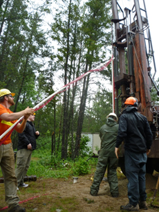 |
The USGS recently entered into a new 5-year Memorandum of Understanding (MOU) with Enbridge Energy, Limited Partnership (Enbridge), the Minnesota Pollution Control Agency (MPCA), and Beltrami County. The MOU continues the voluntary and cooperative venture to maintain the long-term research site in Beltrami County for research concerning the fate of crude oil in the environment at the National Crude Oil Spill Fate and Natural Attenuation Research Site (site). The collaborative effort aims to promote valuable research while also protecting the environment. The site was featured in two recent news stories, just weeks ahead of another busy field season: In Bemidji, a research site reveals secrets of an oil spill, from StarTribune on June 15, 2014, and At an old Minnesota oil spill site, scientists discover oil-eating microbes, from Minnesota Public Radio on June 4, 2014. The 2014 field season is scheduled for July 21 – August 1. This summer's project topics range from developing improved, less-invasive methods for assessing biodegradation to better understanding secondary arsenic mobilization to exploring ways to remediate and rehabilitate water-repellent soil. We expect 30 or more researchers, who will be working on more than a dozen different projects during the annual action-packed field season.
New Projects Started with Funding from the LCCMR
The Center is involved in new and newly continued projects funded by the Environmental and Natural Resources Trust fund through the Legislative and Citizens Commission on Minnesota Resources. A short description of the new projects follows:
Hydrologic Study of Glacial Confining Units
Confined glacial aquifers provide water to many residents in Minnesota. An important factor affecting the long-term sustainable availability of water from these aquifers is infiltration through overlying glacial till confining units. Few data exist, however, on the vertical hydraulic properties and infiltration rates through till. The lack of detailed infiltration and hydraulic data hinders the State's efforts to define the sustainability of confined aquifers. The proposed study will increase understanding of the role of till confining units in water supply and the hydrologic cycle, resulting in more appropriate management decisions in glacial drift areas.
Watershed Water Budgets
Sustainable groundwater management requires knowledge of the water budget. The water budget is the quantity of water that is flowing through the hydrologic system as well as the amount of groundwater in aquifers (storage). The proposed pilot study will calculate the water budgets, including the groundwater and surface-water flow components, for selected watersheds in St. Louis and Goodhue Counties. The goal of the proposed study is to provide information for proactive water management in two areas undergoing mining exploration.
USGS National Research Program Guest Lecture - September 10, 2014
The Minnesota Water Science Center is pleased to host a National Research Program Lecture. The lecture will be held at the Center, in Mounds View, at 10:30 am. Please email Lindsay Forbes ([email protected]) if you would like to attend. The lecture, by Dr. Kate Campbell, is titled: "Mining, microbes, and models: integrating microbal iron oxidation, precipitation, and biogeochemical modeling, with application to acid mine drainage at Iron Mountain Mine, California."
Lecture description: Acid mine drainage (AMD) is a major environmental concern because of high concentrations of acidity (low pH), sulfate, iron, and other elements. One important process affecting AMD chemistry is microbial Fe(II) oxidation. As Fe(II) oxidizes, a variety of Fe(III)-bearing minerals can precipitate, affecting the immobilization of elements such as Cu and Zn, as well as redox cycling of trace elements such as As and Sb. Precipitation can also cause costly management problems when it interferes with treatment efforts. An example of this problem occurred at the Iron Mountain Mine, California, where a pipeline carrying AMD developed scaling because of Fe(II) oxidation and Fe(III) precipitation inside the pipe. The scale accumulation clogged flow and caused spillage of AMD, requiring expensive periodic cleaning of the pipeline.
Laboratory Fe(II) oxidation experiments were conducted using synthetic AMD with Fe(II)-oxidizing bacteria, and compared to experiments using natural AMD from Iron Mountain. Changes in pH, Fe(II), Fe(III), and trace elements were measured over time. The precipitates formed were characterized, and the microbial community was identified. Water samples and scale collected from four locations along the pipeline also were characterized.
We developed a geochemical model to evaluate our understanding of coupled biotic and abiotic processes in AMD. Key processes included in the model are equilibrium reactions for all measured constituents, microbial Fe(II) oxidation kinetics, Fe(III) hydrolysis and polymerization, mineralogy, solubility, Fe(III) precipitation kinetics, and As(III) oxidation. This work highlights the utility of geochemical models as a means of improving quantitative descriptions of fundamental biogeochemical processes in AMD. Based on the geochemical model and laboratory experiments, we developed a potential mitigation strategy for the scaling problem that avoids costly pipeline maintenance.
KATE M. CAMPBELL
Kate M. Campbell is a biogeochemist with the National Research Program, U.S. Geological Survey, Boulder, Colorado. She received a BS in Chemistry from Georgetown University and an MS and PhD in Environmental Engineering from the California Institute of Technology. She worked on bioremediation of uranium for her postdoctoral work at the USGS in Menlo Park, California before joining the chemical modeling of acid waters group. Her research focuses on abiotic and biotic redox chemistry of natural waters, including acid rock drainage, geothermal waters, and groundwaters; biogeochemical modeling of kinetically controlled processes, especially iron, arsenic, antimony, and uranium redox chemistry; coupled biotic-abiotic controls on microbial ecology in geothermal and mining environments; and novel sampling techniques for redox processes for field application.
Kate Campbell, NRP Central Region, Boulder, CO, [email protected], (303)541-3035
Products and Reports Cont.
New Study Finds Contaminants of Emerging Concern in Minnesota Groundwater
A study of contaminants of emerging concern (CECs) in ambient groundwater in urbanized areas of Minnesota was completed by the U.S. Geological Survey in cooperation with the Minnesota Pollution Control Agency. A total of 123 water samples were collected from 118 wells located in different land-use settings. The sampled wells primarily were completed in vulnerable sand and gravel aquifers (surficial and buried glacial aquifers) or vulnerable bedrock aquifers such as the Prairie du Chien-Jordan aquifer. Samples were analyzed at U.S. Geological Survey laboratories for steroidal hormones, human-use pharmaceutical compounds, human- and animal-use antibiotics, and a broad suite of organic chemicals associated with wastewater. During this study, 35 distinct CECs out of 125 CECs analyzed were detected among 123 water samples collected. The number of detections of CECs in individual water samples ranged from 0 to 10. The three wells in proximity to landfills had the most CEC detections. One or more CECs were detected in a total of 43 samples (35 percent); no CECs were detected in 80 samples. All detections in this study were less than established health-based water-quality standards, but only 14 of the 35 chemicals detected have established water-quality standards. Four of the six most frequently detected chemicals-azithromycin, diphenhydramine, tributyl phosphate, and lincomycin—have no health-based water-quality standards or benchmarks.
The antibiotic sulfamethoxazole was the most frequently detected CEC. Most of the detections of sulfamethoxazole were in samples from domestic wells or monitoring wells located in areas where septic systems or potentially leaking centralized sewers are prevalent. Tris(2-chloroethyl) phosphate [(FYROL CEF)], the only chemical detected at a concentration nearing a health-based water quality standard, and bisphenol A, detected second most frequently, were both detected most frequently in wells in proximity to closed landfills.
These results were featured by Minnesota Public Radio in the June 2014 story Chemicals spreading in Minnesota groundwater.
Contact: Mindy Erickson ([email protected]).
Full Report
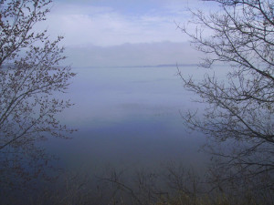
Mississippi Webcam is Now Available
We have added a link to the City of St. Paul's river webcam on our gage home page for Mississippi River at St. Paul. We considered adding a webcam at the USGS streamgage as part of our Flood Inundation Mapping project for St. Paul, but have discovered that the City of St. Paul gage provides a good view of the river. To find the link from the USGS gage webpage, look for "City of St. Paul Webcam" under the station-specific text in the upper one-third of the page: http://waterdata.usgs.gov/mn/nwis/uv/?site_no=05331000
It can also be found on the City of St. Paul's website: http://www.stpaul.gov/index.aspx?NID=4592
|