
Minnesota Water Science Center Newsletter
Spring 2013
U.S. Geological Survey
Minnesota Water Science Center
2280 Woodale Drive
Mounds View, MN 55112
http://mn.water.usgs.gov
Report on Groundwater and Surface-Water Interactions near White Bear Now Available Online
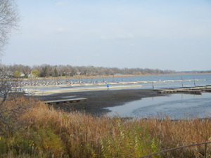 |
The U.S. Geological Survey, in cooperation with the White Bear Lake Conservation District, the Minnesota Pollution Control Agency, the Minnesota Department of Natural Resources, and other agencies and private organizations, have completed a study to characterize the hydrology of White Bear Lake. The study indicated that a combination of lower precipitation and an increase in groundwater withdrawals can explain the changes in the lake level. The relation between average annual lake-level and annual precipitation changed from 1978-2002 to 2003-11, requiring an average of 4 more inches of precipitation per year to maintain the lake level.
Annual and summer groundwater withdrawals from the Prairie du Chien-Jordan aquifer more than doubled from 1980 through 2010. Study results indicated groundwater withdrawals had a greater effect than precipitation on water levels in the White Bear Lake area since 2003. The recent (2003–2011) decline in White Bear Lake reflects the declining water levels in the Prairie du Chien-Jordan aquifer.
Groundwater-level and lake-level measurements during the study indicate groundwater was potentially flowing into White Bear Lake from glacial aquifers to the northeast and south, and lake water was potentially discharging from White Bear Lake to the glacial aquifer in other areas as well as to the Prairie du Chien-Jordan aquifer. Groundwater levels in the Prairie du Chien-Jordan aquifer underlying White Bear Lake are approximately 0 to 19 feet lower than surface-water levels in the lake.
Water-quality analyses of well-water, precipitation, and lake-water samples indicate wells down gradient from White Bear Lake receive a mixture of surface water and groundwater. The greatest surface-water contributions are in wells closest to White Bear Lake, and White Bear Lake is the likely source of the surface-water contributions to those wells.
Full Report
Contact: Perry Jones 763-783-3253
Employee Highlight-Chris Ellison: Civil Servant of the Year
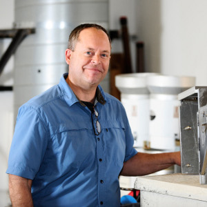 |
Chris encourages his staff to think of new ways to expand the scope of the sediment program. He began a sediment bed load analysis laboratory at the University of Minnesota and a geomorphology study with the city of Duluth. Chris has worked with Gustavo Merten, a professor from Brazil, who currently works at the University of Minnesota, and has made partnerships and developed studies with the Minnesota Department of Natural Resources and the Minnesota Pollution Control Agency. Chris maintains his positive attitude regardless of the situation, which is helpful in keeping those who work with him motivated. He is willing to help others even if it means working late into the day or on the weekend.
Contaminants of Emerging Concern Research and Monitoring at the MNWSC
The USGS Minnesota Water Science Center (MNWSC) is engaged in scientific studies to understand the occurrence, fate, and effects of contaminants of emerging concern in surface water, groundwater, wastewater, and drinking water throughout Minnesota and surrounding Great Lakes States. These studies are accomplished through involvement in the USGS Toxics Substances Hydrology Program, in cooperation with other Federal agencies such as U.S. Fish and Wildlife Service and National Park Service, and in cooperation with local State agencies (Minnesota Departments of Health and Natural Resources, Minnesota Pollution Control Agency, Metropolitan Council Environmental Services, and multiple drinking water and wastewater facilities) and Universities (St. Cloud State University, University of Minnesota, University of St. Thomas) through the USGS Cooperative Water Program.
What are Contaminants of Emerging Concern?
Contaminants of emerging concern (CECs) is a term used to describe a broad group of chemicals including prescription drugs (serotonin inhibitors, anti-anginals, antibiotics, stimulants, relaxants), over-the-counter medications (caffeine, ibuprofen, diphenhydramine), reproductive hormones (17β-estradiol, testosterone, estrone), synthetic hormones (17α-ethynyl estradiol, mestranol), personal-care products (synthetic musk’s, triclosan, flavors), surfactants (alkylphenols), plastic components (bisphenol A), flame retardants (triphenyl phosphate), and an array of other chemicals.
Where are the Sources and Pathways of CECs?
 |
What Have We Learned?
 |
What are Current and Future Directions?
The MNWSC has several ongoing studies to address the occurrence, fate, and effects of CECs in Minnesota water resources including characterization of fish responses to wastewater effluent in the St. Croix River Basin, occurrence of CECs in Great Lake’s tributaries, characterization of CECs in shallow groundwater, and fate of CECs in lake ecosystems.
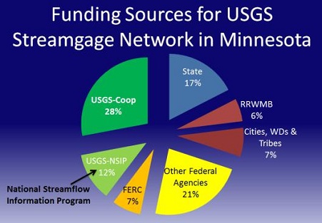
The Importance of Streamgages in Minnesota
Uses of streamflow information touch citizens’ lives daily. Streamgages, like bridges and dams, are a vital part of the Nation’s water infrastructure. In Minnesota, the streamgage network is the result of cooperative efforts by the U.S. Geological Survey (USGS), the U.S. Army Corps of Engineers, Minnesota Department of Natural Resources, the Minnesota Department of Transportation, the Minnesota Pollution Control Agency, the Metropolitan Council of the Twin Cities, the Red River Watershed Management Board, Tribes, and local watershed agencies, counties, and cities. This network provides reliable streamflow information: flood warnings and forecasts; drinking water management; water withdrawals; hydroelectric production; wastewater discharges; reservoir releases; legal and treaty obligations for interstate and international waters; preservation of aquatic habitats; water-quality standards; recreation; infrastructure designs for highways, bridges, culverts, dams, and levees; and for scientific investigations of streamflow trends, ecosystem health, and climate change.
 |
Endangered Streamgages:
Unfortunately, funding challenges continue to erode the national streamgage network. Since 1990, more than 600 USGS streamgages with records of more than 30 years have been discontinued across the Nation. More than 350 streamgages are currently threatened or endangered for closure due the Federal budget sequestration. In Minnesota, more than a dozen streamgages have been discontinued in the past decade. Confronted by this challenge, USGS and its partners are committed to continually seek new avenues of support and innovation that promotes more cost-effective monitoring.Flood Warnings, Forecasting, and Outlook:
USGS streamgages transmit streamflow data so that information is publicly available in real time (updated hourly). The information includes data for the full range of streamflow conditions, which are critical to protect and minimize loss of life and property from flood hazards, and to plan for the mitigation of droughts.USGS streamgage information is used by the National Weather Service (NWS) to forecast floods and issue warnings to protect lives and property. The U.S. Army Corps of Engineers (USACE) takes flood-control measures based on USGS streamgage information. Local agencies prepare for floods based on USGS river measurements.USGS staff in Minnesota are preparing for this spring’s flood threat, which currently appears greatest in the Red River Basin. Rapid temperature increases or rains falling on deeply frozen soils could exacerbate flooding anywhere in the State.
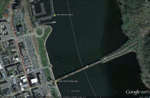
Streamgage Data Used for Flood-Inundation Warning System for the City of St. Paul:
The public and emergency planners can better understand the consequences of flood forecasts in terms of areas that will be inundated.Using hydraulic modeling and digital elevation data, flood inundation maps depict estimates of the area and depth of flooding corresponding to water levels observed at the USGS streamgage for the Mississippi River at St. Paul, and will be available to the public through the NWS at http://water.weather.gov/ahps/. The maps aid in emergency management planning and response activities, such as evacuations and road closures, as well as for post-flood recovery efforts.
USGS Streamgage Data Used to Estimate the Probabilities of June 2012 Floods in Northeast Minnesota:
Long-term streamflow data are critical to understanding the magnitude, probabilities, and trends of floods. In cooperation with the Federal Emergency Management Association (FEMA) and other Federal and State agencies, the USGS published a report documenting the frequency and magnitude of June 2012 floods in northeast Minnesota (http://pubs.usgs.gov/sir/2012/5283/). Many USGS streamgages recorded peaks of record, some with annual exceedance probabilities of less than 0.2 percent; also referred to as recurrence intervals greater than 500 years. Flood inundated areas also were surveyed and documented for selected communities.Consistent and Broad Records of Streamflow Increase Knowledge:
One of the highest priorities of the USGS is to maintain the stability of the streamgage network in recognition that long-term, consistent, systematically collected information is paramount to track climate and land-use changes; improve flood forecasting models; and monitor flows in rivers that serve heavily populated areas or that sustain vital aquatic communities. Such data become more critical as our population grows, driving more need to sustain water for competing priorities. A robust network is also vital to support ongoing USGS science that provides critical streamflow estimates at ungaged locations, which is essential because it is not economically feasible to measure all rivers and streams at all the most important locations.Due to recent budget cuts as a result of sequestration, USGS will discontinue operation of as many as 375 streamgages nationwide. Additional streamgages may be affected if partners reduce their funding that supports USGS streamgages. Even though the operation of most streamgages is now highly automated, the streamgages still require periodic maintenance to ensure physical stability and for instrument calibration, communication adjustments, and battery replacement. The USGS is working to identify which streamgages will be impacted and will post this information as it becomes available.
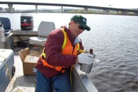
Current Water-Quality Studies in the St. Croix River Watershed
Stillwater, MN, streamgage:
 |
Sampling at Apple, Willow, and Kinnickinnic Rivers:
Water-quality data are being collected from several Minnesota tributaries to Lake St. Croix by State and local partners. However, recent nutrient data collections for the three largest Wisconsin tributaries to Lake St. Croix have been limited to seasonal sampling by the National Park Service and the USGS. Federal Highway Administration mitigation funds from the Wisconsin Department of Natural Resources are planned to reestablish streamflow and water-quality monitoring at the Willow River and to begin routine nutrient sampling at all three rivers. These data will enhance the computation of nutrient loads to Lake St. Croix, allowing the USGS and St. Croix Basin Team partners to evaluate progress in implementing nutrient management plans in the basin.
Lake St. Croix continuous water-quality monitoring:
Previous nutrient-loading models for Lake St. Croix assumed that oxygen-rich environments were present throughout the lake. Recent monitoring has revealed periods of no oxygen (anoxia) in deep areas of Bayport, Troy Beach, Black Bass, and Kinnickinnic pools. Continuous monitoring of dissolved oxygen, temperature, and algal abundance in surface and deep waters in the two lower pools of the lake will track algal bloom formation and provide data necessary for water-quality model validation.
Productivity and Fish Habitat responses to Changes in Nutrient Loading and Climate in Lake St. Croix:
The USGS Minnesota Water Science Center is developing a hydrodynamic, biophysical water-quality model for Lake St. Croix in cooperation with the National Park Service and the Science Museum of Minnesota St. Croix Research Station. The CE-QUAL-W2 model can be used to simulate Lake St. Croix responses to current climate and land-use conditions in the watershed using estimated nutrient loads and measured inflow and outflow. The model will incorporate internal nutrient loading from the deep, anoxic pools in the lake while simulating algal responses to nutrient availability along the entire length of the lake. In addition, the model can be used to simulate seasonal changes in temperature and dissolved oxygen habitat for fish and other aquatic organisms. The model can be used to assess lake ecosystem response to a 20-percent phosphorus load reduction under implementation lake management plans and be linked with nutrient loading estimates from the a watershed model developed by the Science Museum of Minnesota St. Croix Research Station.
Contact: Richard Kiesling 763-783-3131