Minnesota Water Science Center
MN PUBLICATIONS
ABOUT THE MINNESOTA
|
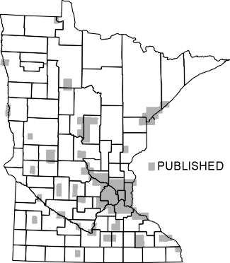
The U.S. Geological Survey (USGS) maps, describes, and seeks to understand Minnesota's mineral, water, and biological resources. The USGS is known for impartial data collection and data interpretation that enable resource planners and others to make informed decisions. Today's issues are more pressing than ever-- understanding natural hazards to minimize their effects on life and property, the continuing need for mineral- and water-resource development, and understanding the effects of human activities on water resources. As the Nation's leading natural-science agency, the USGS works with other Federal agencies and State and local agencies in addressing these issues. Watershed districts; soil- and water-conservation districts; Tribal governments; mining industries; educators; city, county, regional, State, and Federal planning agencies; consulting firms; crop consultants; farmers; and other private citizens use USGS maps, interpretive reports, and data to manage Minnesota's resources. Economic growth and development in Minnesota depend, in part, on the availability of local sources of minerals for use in industry and manufacturing and for maintaining and upgrading transportation networks. Raw materials, such as sand and gravel, are needed by State agencies and private industrial and construction firms to construct roads and buildings. To ensure continued growth and development of industry, new sources of construction materials and other mineral resources must be identified because existing supplies are limited and because land-use constraints rule out exploitation of some geologic resources. Minnesota not only contains identified resources of iron, copper, and nickel, the State also has potential for developing gold, zinc, platinum, and other minerals of local, national, and global importance. Extraction and processing of these mineral resources could form the basis for enhanced local and regional economies. The USGS is developing an integrated digital geologic, geochemical, geophysical, and mineral-resource database and assessment of undiscovered mineral resources in the State. This database can be used to address regional land use, environmental, and mineral-resource issues. A recent product, prepared in cooperation with the Minnesota Geological Survey, is the digital geologic bedrock map for Minnesota, Wisconsin, and Michigan. Maps and reports in digital and paper form assist Federal, State, and local land-management agencies to ensure adequate supplies of minerals at low cost and to promote sound management of the region's substantial mineral resources. The USGS statemap Program is supporting detailed geologic mapping at the 1:24,000 scale of an area of rapidly expanding population southwest of Minneapolis. The Program provides digitized geologic data for use by planners and resource managers in dealing with land-use issues including well-head protection, septic-system regulation, open-space set-asides, sand and gravel resource protection, and flood-related zoning. Water is a significant economic and recreational resource of Minnesota, making the State well known as ``The Land of 10,000 Lakes.'' During 1995, about 79 percent of all Minnesotans obtained their domestic supplies from ground water and nearly 750 million gallons of ground water were withdrawn every day. During the past 20 years, ground-water withdrawals from glacial and bedrock aquifers in Minnesota have increased, particularly for irrigation in areas of sandy soils. Irrigated acreage in many sandy areas increased by a factor of 10 during the 1970's, according to the soil and water conservation districts. Anticipated future changes in land use, population, and economic development also will increase ground-water withdrawals. Because of these increased demands, State and local agencies are concerned about the effects of drought on water supplies, long-term sustainable yields of wells, effects of pumping on ground- and surface-water levels, and interferences among nearby wells pumping from the same aquifer. 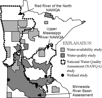 Figure 1. Selected water-resources investigation study areas in Minnesota, 1980-1997 (click to view full-sized image). The USGS is the leading Federal agency in Minnesota that collects and interprets water-resource data and information used by resource managers, planners, and the general public. To define the availability of water for public, irrigation, and industrial supplies, the USGS monitors streamflow, lake levels, and ground-water levels at many locations and has studied numerous aquifers in Minnesota (fig. 1). These studies have mapped and quantified water supplies for Minneapolis, St. Paul, Rochester, Moorhead, and other cities. Typically, the studies describe the effects of present and future ground-water withdrawals on the levels and quality of ground water and streams. Some specific uses of the USGS studies by cities, counties, and regional groups include development of ground-water protection plans, enhancement of water-supply systems, and evaluation of the possible effects of urban development. Some study results were instrumental in helping water-resource managers evaluate the vulnerability of local ground-water resources to contamination. Tribal officials of the Grand Portage Indian Reservation used results of a USGS study to develop alternative community water supplies from Lake Superior. Expansion of urban and industrialized areas and development of agricultural resources during the past 50 years have adversely affected some water resources. State and local water managers and the citizens of Minnesota are concerned about the effects of human activity on the quality of Minnesota's streams and ground water. There is increased emphasis on relating land use to effects on water quality of streams and aquifers, not only within a drainage basin, but in downstream basins as well. Consequently, many of the most recent requests for USGS assistance have been related to water-quality issues. Of particular interest to water managers are the water-quality effects of applying nutrients and pesticides to agricultural crops.
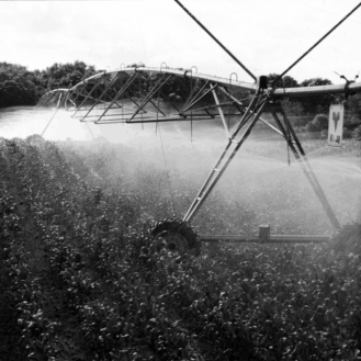
To determine the quality of water in Minnesota's streams and lakes, the USGS maintains 4 surface-water-quality stations, 2 sediment stations, 12 lake stations, and 1 precipitation station. The USGS also has completed numerous studies of ground-water quality. The USGS studies water quality at scales that range from a farm field (fig. 2) to regional drainage basins in the 12-State Midwest Corn Belt. Ongoing regional studies of water quality cover most of the major drainage basins in Minnesota. A study of the Minnesota River Basin determined how suspended sediment, agricultural chemicals, and bacteria impair use of the river water. The effects of conventional and improved farming practices on water quality are being examined in several farm-field studies. The results of one study have shown that as much as one-third of the nitrogen applied to a typical corn crop in sandy soils reaches the ground water. The USGS also is studying the environmental effects of an oil spill near Bemidji that is similar to other sites of contamination across the Nation. The results of this study may help reduce the costs of cleaning oil-contaminated ground water. The results of USGS water-quality studies provide water managers with essential information needed to make ground-water management decisions throughout Minnesota. State regulatory agencies are using the results of USGS studies to develop new agricultural best-management practices for farmers to reduce stream and ground-water contamination. The USGS is evaluating hydrologic changes due to changes in agricultural practices, such as adding vegetative and woody buffer strips in cropland watercourses. Tribal officials used study results to develop plans to close existing landfills, to site new landfills, to assess the health of a large lake, to evaluate mercury contamination of a major river, to assess nitrate contamination of ground- and surface-water resources from a large feedlot operation, and to develop a pesticide-control ordinance. Networks of USGS monitoring wells in many of the aquifers in Minnesota are now used by State and local groups to monitor water quality. A critical factor in understanding water quality is the ability to make comparisons among different locations through time. Nationally consistent and comparable information is needed to make valid statements about regional and national water-quality conditions now and in the future. Assessments are needed that identify the natural and human factors that affect the quality of the Nation's surface- and ground-water resources. The USGS National Water-Quality Assessment (NAWQA) Program was established to address these needs. NAWQA studies in the Red River of the North and the Upper Mississippi River Basins investigate nonpoint- and point-source water-quality issues in Minnesota and adjacent States. Within the Red River of the North Basin, the quality of water in streams and surficial aquifers is dependent on geology, soils, and hydrology. Only small amounts of agriculturally applied pesticides and nutrients have reached streams and shallow ground water. Streams draining areas with much cropland have the highest concentrations of nutrients. Although differences in fish communities appear to be governed by natural environment factors, chemicals associated with modern industrial sources were widely detected in fish and stream sediment in the basin.
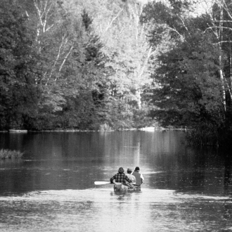
The results of sampling in the Upper Mississippi River Basin suggest that urban use contributes to elevated concentrations of nutrients and several pesticides and synthetic organic compounds in ground water and streams. Nutrient concentrations in streams and rivers generally are related to land use, and concentrations are greatest in the St. Croix River, a National Scenic Waterway. The results of the NAWQA study along the St. Croix National Scenic Waterway (fig. 3) will benefit the National Park Service in managing this scenic recreational area. The NAWQA studies are prompting cooperation among State agencies in Minnesota, North Dakota, and Wisconsin and various Provincial and Federal agencies in Canada to consider consistent, basin-wide approaches to monitoring water quality in the Red River of the North and the Upper Mississippi River Basins. The quantity and quality of streamflows in most of Minnesota are controlled by ground water during periods of low rainfall. State and local agencies are concerned about the effects of ground-water withdrawals on streamflow and stream-water quality. There also is concern that contamination within the aquifers or the streams could adversely affect public water supplies. Water managers can benefit from additional information about how streams are affected by ground-water withdrawals from adjacent aquifers and about how poor water quality in these aquifers affects streams. The USGS has studied the interaction of ground water and streamflow at several sites in Minnesota. One study found that, during the 1988-89 drought, the Mississippi River did not lose water to the adjacent ground-water system. The city of Minneapolis and the U.S. Army Corps of Engineers used results of this study to plan for future droughts. The USGS is studying interaction of the Rock River with the surrounding alluvial aquifer because sources of contamination to the river are present upstream from ground-water-supply wells in Luverne. State and local water managers are benefiting from significant project results about how ground-water quality is affected as a result of inducing flow from the Rock River into the aquifer, which is one of the largest and most productive alluvial aquifers in southwestern Minnesota. Recent USGS work in the Red River of the North Basin used chemical dating methods to determine the age of water in a shallow aquifer. The youngest water was near the surface of the aquifer, which also had the highest concentration of nitrate. The results have strong implications for nitrate transport in ground water, and the results may be useful for resource managers and planners for devising ground-water protection strategies. The USGS is studying how existing and restored wetlands in agricultural and other landscapes can store flood water, settle suspended soil particles, and alter or remove fertilizer and pesticides by plant uptake and microbial action. The USGS studies provide water managers in Federal and State agencies with a better understanding of how efficiently restored wetlands can reduce flooding and improve water quality. Such information will help water managers identify locations where wetland preservation and restoration can strike the best balance between ecological and economic imperatives. Coastal wetlands of Lake Superior protect the drinking water and shoreline communities of Minnesota. Many processes have been interacting to cause the deterioration of Lake Superior's wetlands since the glaciers melted. Histories of wetlands along the Minnesota coast are included in a geographic information system map that is being prepared for Lake Superior. Use of the map to monitor the changes in the wetlands through time will provide a predictive tool for land-use planners, political jurisdictions having to sort out conflicting best-management practices, and scientists trying to understand the geological limits of biodiversity. Hydrologic data are needed for hazard warning, hydroelectric power, irrigation, management, operation, planning, pollution abatement, water-resource development, water supply, and wildlife management. To address the needs of water managers and the citizens of Minnesota, the USGS operated 170 daily- or partial-record streamflow-gaging stations in 1997 (fig. 4). Data from these stations are added to a national data base each year for easy access. Floods throughout the State threaten lives and property, annually cause millions of dollars in property damage and remediation costs, and disrupt commerce. The damage to bridges and other structures caused by channel scour or migration during a flood can cost millions of dollars. Because many of Minnesota's cities are adjacent to rivers, knowledge of probable flood discharges and river elevations is needed for designing new bridges or near-stream housing developments. 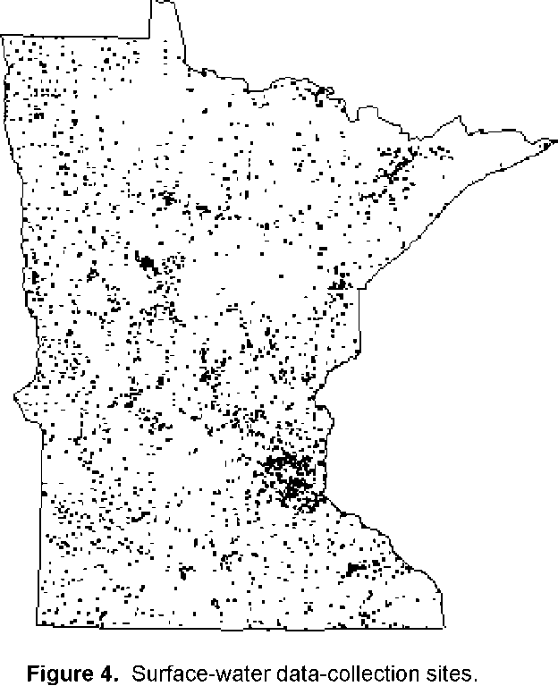 Figure 4. Surface-water data-collection sites (click to view full-sized image).
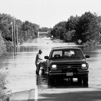
The 1988-89 drought and the 1993 flood (fig. 5) are two recent natural disasters that illustrate the need for the long-term, consistent hydrologic information obtained by the USGS. During the 1988-89 drought, the Minnesota Department of Natural Resources required continuous streamflow information throughout the State to protect fish and guard against excessive water use. In addition, USGS data were used by the U.S. Army Corps of Engineers to manage and operate their locks, dams, and reservoirs and were used by many cities to manage their water supplies and sewage-treatment plants. During the 1993 flood, the U.S. Weather Service depended on the USGS for accurate and continuous water-flow data to forecast flooding and prevent or minimize damage to public and private property. Among the most popular and versatile products of the USGS are its topographic maps at the scale of 1:24,000 (one inch on the map represents 2,000 feet on the ground). This scale is useful for civil engineering, land-use planning, natural resource monitoring, and other technical applications. Minnesota is covered by 1,725 of these maps, which have long been favorites with the general public for outdoor uses, including hiking, camping, exploring, and back-country fishing expeditions. Since 1991, Minnesota's Land Management Information Center (LMIC) has cooperated with the USGS to update more than 100 topographic maps (fig. 6). The USGS has produced statewide coverage of digital raster graphics (DRG's), through cooperation with other agencies. These products can be as used an accurate base for a geographic information system. The DRG's are available for all 1:24,000-, 1:100,000-, and 1:250,000-scale topographic maps in the State.
The USGS and LMIC have cooperated to produce statewide digital orthophoto quads (DOQ's). These digital images provide a ``snapshot'' of the Earth's surface that has the accuracy of a topographic map. The DOQ data are available for most counties in the State on CD-ROM's. Also, the USGS has produced digital elevation models that cover the State at 1:24,000 scale. The Department of the Interior's Federal Geographic Data Committee (FGDC) and the State of Minnesota have actively participated to promote data sharing in the State. The FGDC has recognized the Minnesota Governor's Council on Geographic Information (GCGI) as a cooperating partner in developing of the National Spatial Data Infrastructure. The FGDC also awarded a grant to the LMIC, the GCGI, and the Metropolitan Council of the Twin Cities as part of a Framework Demonstration Project Program to assess multipurpose data requirements. The Lake Superior shoreline in Minnesota and other areas is slowly sinking as a result of residual uplift of the outlet following glacier retreat 9,800 years ago. The lake level is controlled by the outlet at Sault Ste. Marie, Michigan; the outlet is rising more rapidly than most other points along the shore. Consequently, the lake level is rising about 1 inch per decade near Duluth where the Lake has risen as much as 18 feet. Submerged wetlands and forests are evident below the present lake level. Rising lake levels attributable to uplift at the outlet will continue to inundate low-lying areas and river mouths, expand wetlands, and contribute to erosion of exposed and erodible shores. Engineers and water managers in Duluth, and elsewhere along the Lake Superior shoreline, will benefit from results of this study in making management decisions. The Earth Science Information Centers (ESIC's) provide information to the public about USGS programs, products, and technological developments. The ESIC in St. Paul was established under a cooperative agreement with the LMIC. The University of Minnesota's Wilson Library in Minneapolis also is a State ESIC. As part of a national ESIC network, these offices provide information on topics such as cartography, geography, digital data, remote sensing, geology, geophysics, geochemistry, hydrology, geohydrology, aerial photography, and land use. |
![]() U.S. Department of the Interior |
U.S. Geological Survey
U.S. Department of the Interior |
U.S. Geological Survey
URL: http://mn.water.usgs.gov/publications/pubs/stsheet/index.html
Page Contact Information: Webmaster
Page Last Modified: Wednesday, 05-Jan-2011 11:21:17 EST