Employee Highlight: Danny Morel
Hydrologic technician Danny Morel processes water-
quality samples from the St. Louis River estuary on the
shore of Lake Superior. |
Danny Morel has been working at the Minnesota Water Science Center (MN WSC) since the summer of 2014, when he first joined as a USGS-National Association of Geoscience Teachers intern under the mentorship of Perry Jones, a MN WSC hydrologist. Danny’s work has been crucial on a USGS study that will assess the effect of Duluth Complex copper-nickel mining on water quality. Danny attended every field sampling effort since his arrival, managed the water-quality data, and generated maps and plots for the study. Danny also contributed to other studies, including geospatial analysis for the Metro Lakes study and helping our data section with streamflow measurements. In addition to his studies work, Danny coordinated the successful launch of the USGS Science in Minnesota Facebook group, which now has more than 380 followers (and counting!). Outside of work, Danny enjoys hiking, traveling, listening to music, and playing Ultimate Frisbee. A graduate of Macalester College in 2013, Danny will be leaving the MN WSC this fall to continue his studies at the University of California, Santa Barbara, pursuing a Master of Science degree in Geology. We’re sorry to see him go, but wish him the best in his future endeavors. See more about Danny and the USGS Science in Minnesota on Facebook at https://www.facebook.com/usgsmn/.
Tim Cowdery Named the Minnesota Water Science Center’s Employee of the Year
Tim Cowdery (in photo on right) receives the
Minnesota WSC’s employee of the year award |
In May, Tim Cowdery was honored as the MN WSC’s Federal Civil Servant of the Year in a ceremony facilitated by the Twin Cities Federal Executive Committee. Tim, a hydrologist with the MN WSC, was honored, along with fellow recipients from other Federal agencies, at the event in Bloomington, Minnesota.
Dr. Chris Ellison Transfers to Wyoming
On April 13, staff from the MN WSC met after hours for a farewell send-off for Dr. Chris Ellison. Chis has transferred to the Montana-Wyoming Water Science Center in Helena, Montana, to become one of the Investigations Section managers for their Center. Chris has done a tremendous job of building the USGS sediment program. His dedication, skill, and positive attitude will be greatly missed as he takes on new responsibilities in Montana.
Visiting Scientist from Brazil
Visiting scientist, Samuel Costa helping with
sediment measurements |
Scientist Samuel Costa arrived on April 1 from São Paulo, Brazil, to intern at the Center through November. Samuel will then return to Brazil to implement USGS sediment sampling protocols and to improve understanding of sediment transport relations in Brazilian rivers. This internship is the result of collaboration among MN WSC staff and Brazilian scientists on programs related to sediment studies in both Minnesota and Brazil.
Samuel works with Sedimentation Engineering at the Institute for Technological Research - IPT, in São Paulo. He attends the University of Sao Paulo and is working towards a Master’s Degree in Hydraulic Engineering. His most recent projects dealt with soil erosion control, suspended sediment measurements, and reservoir monitoring. He came to the USGS looking forward to learning new methods and techniques for sediment sampling, with a special interest on hydroacoustic technologies as surrogates for measuring sediment loads.
USGS Online Mapper Provides a Decadal Look at Groundwater Quality
Increases in chloride concentrations were observed in 31
groundwater networks across the Nation. The online
mapper examines decadal changes in 24 contaminants,
such as nutrients, pesticides, metals,
and volatile organic compounds.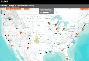 |
A new online interactive mapping tool provides summaries of decadal-scale changes in groundwater quality across the Nation. About 140 million people—almost one-half of the Nation’s population—rely on groundwater for drinking water. Tracking changes in groundwater quality and investigating the reasons for these changes are crucial for informing management decisions to protect and sustain our valuable groundwater resources. The mapper shows how concentrations of 24 contaminants, such as nutrients, pesticides, metals, and volatile organic compounds, are changing over decadal periods in 67 groundwater networks across the Nation. Each network consists of about 20 to 30 wells selected to represent water-quality conditions in a given geographical area, aquifer, and in some cases, a specific land use. The mapping tool is one component of the National Water-Quality Assessment Project’s ongoing efforts to assess, understand, and forecast the quality of the Nation’s groundwater.
ACCESS THE MAPPER: http://nawqatrends.wim.usgs.gov/decadal/
New Publication for Understanding Flow Direction on Border Lakes
USGS field technicians installing an acoustic Doppler
velocity meter (ADVM) between Kabetogama and
Namakan Lakes. 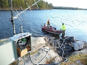 |
A new publication by Victoria Christensen (MN WSC), Eric Wakeman (MN WSC) and Ryan Maki (National Park Service) describes Kabetogama and Namakan Lakes in Voyageurs National Park. Kabetogama Lake historically has had high nutrient concentrations, recurring algal blooms, and elevated levels of a known toxin, Microcystin, which can be harmful to humans, pets, and wildlife. Namakan Lake, however, is relatively pristine. The hydrology of the area is complex and water flows in both directions. Therefore, this study used a modern acoustic Doppler velocity meter to account for wind, waves, and changing flow direction in combination with water analysis to determine flow direction and nutrient transport. Results indicate that Kabetogama Lake water flowed into Namakan Lake as much as 70 percent of the time, which may have a negative effect on the more pristine lake. This study is considered essential to understanding changes in water flow, water quality, and ecological consequences of water-level management and the dams that regulate these waters.
Contact: Vicki Christensen.
Citation: Christensen, V.G., Wakeman, E.S., and Maki, R.P., 2016, Discharge and nutrient transport between lakes in a hydrologically complex area of Voyageurs National Park, Minnesota, 2010-2012: Journal of the American Water Resources Association (JAWRA), v. 52, no. 3, p. 578-591, http://dx.doi.org/10.1111/1752-1688.12412.
Border Waters Rule Curve Review
The above study is just one of the many that the USGS has led that are related to water levels on the border between the United States and Canada. The Rainy-Namakan Lakes Rule Curves Study Board has been reviewing all available rule curve studies to determine the effects on the border lakes. They plan to present their findings in July. Rule curves are bands established by the International Joint Commission that show maximum and minimum allowable water levels. The USGS has been involved in many of the more than 50 studies. Other examples of USGS studies are: Lake Levels and Environmental Variables Related to Fish Mercury Body Burdens, Voyageurs National Park (current study); Trophic State Before and After Implementation of a Revised Water-Level Management Plan; Using Molecular Tools to Understand and Predict Cyanobacterial Harmful Algal Bloom Toxicity in Kabetogama Lake, Voyageurs National Park, Minnesota (current study); Relation of Nutrient Concentrations, Nutrient Loading, and Algal Production to Changes in Water Levels in Kabetogama Lake, Voyageurs National Park; and Evaluation of Internal Loading and Water Level Changes: Implications for Phosphorus, Algal Production, and Nuisance Blooms in Kabetogama Lake.
Contact: Victoria Christensen, vglenn@usgs.gov.
USGS Scientists Present at the National Interstate Technology Regulatory Council Meeting
Researchers at Bemidji Crude-Oil Site |
The National Crude Oil Spill Fate and Natural Attenuation Research Site near Bemidji, Minnesota, was featured in two presentations during the National Interstate Technology Regulatory Council’s (ITRC) meeting April 18-22 in Bloomington, Minnesota. The ITRC develops guidance and training documents used by regulatory agencies to guide sampling and management of contaminated sites in every State. Dr. Barbara Bekins (USGS National Research Program, Menlo Park, CA) presented results from a recent publication about petroleum metabolites in groundwater to a working group on total petroleum hydrocarbons. She also gave an invited presentation about past and current research at the Bemidji site at the meeting’s plenary session. Jared Trost (USGS MN WSC) and Dr. Bekins presented a poster about the Bemidji site as well.
Results from the USGS Crude-Oil Research Site Have Implications for Oil-Plume Remediation
USGS scientists collecting groundwater samples
near Bemidji, Minnesota. |
The USGS has been studying the movement and natural degradation processes associated with crude-oil spills near Bemidji since 1983. Two papers on research from the USGS’s Crude-Oil Research site have recently been published. The first examines water chemistry from two groundwater plumes with residual crude oil sources. This research showed that groundwater concentrations of residual crude oil metabolites exceed concentrations of diesel range organics. This finding has important implications because metabolites are largely unmonitored at crude-oil spill sites, yet pose toxicological threats.
The second paper examined seasonal variations in natural attenuation of crude oil. Natural attenuation of the crude oil plume results from microbial degradation of crude oil in the unsaturated zone. Core ideas from the paper are that contaminant mass loss rates vary seasonally, vadose zone temperatures in the source zone correlate with rates of contaminant respiration, and natural soil respiration and gas transport seasonality affect mass loss estimates. This paper advances the soil carbon dioxide efflux method, which estimates hydrocarbon degradation rates without drilling deep holes into the ground. This non-invasive method is very beneficial at many spill sites with dense subsurface infrastructure or other features that make drilling and coring difficult.
Full citations:
Bekins, B.A, Cozzarelli, I.M, Erickson, M.L., Steenson, R.A., and Thorn, K.A., 2016, Crude oil metabolites in groundwater at two spill sites: Groundwater, http://dx.doi.org/10.1111/gwat.12419.
Contact: Mindy Erickson, merickso@usgs.gov
Sihota, N.J., Trost, J.J., Bekins, B.A., Berg, A., Delin, G.N., Mason, B., Warren, E., and Mayer, K.U., 2016, Seasonal variability in vadose zone biodegradation at a crude oil pipeline rupture site: Vadose Zone Journal, v. 15, no. 5, 14 p., http://vzj.geoscienceworld.org/content/15/5/vzj2015.09.0125.
Contact: Jared Trost, jtrost@usgs.gov
Synthetic Hydrographs for Ungaged Streams
Redwood River near Redwood Falls, Minnesota. Flow
statistics are now available at the StreamStats website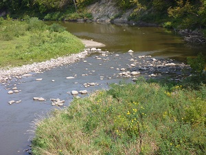 |
Knowing how much water is in a stream is an important part of water-resource management, but streamgages cannot be installed at every location where streamflow data are needed. A new report demonstrates how to use a web-based USGS tool called StreamStats to estimate daily streamflow at ungaged stream locations in Minnesota. The effort is based on work in two reports published in cooperation with the Minnesota Pollution Control Agency.
Full citation:
Lorenz, D.L., and Ziegeweid, J.R., 2016, Methods to estimate historical daily streamflow for ungaged stream locations in Minnesota: U.S. Geological Survey Scientific Investigations Report 2015–5181, 18 p. http://dx.doi.org/10.3133/sir20155181
Ziegeweid, J.R., Lorenz, D.L., Sanocki, C.A., and Czuba, C.R., 2015, Methods for estimating flow-duration curve and low-flow frequency statistics for ungaged locations on small streams in Minnesota: U.S. Geological Survey Scientific Investigations Report 2015–5170, 23 p., http://dx.doi.org/10.3133/sir20155170.
Contact: Jeff Ziegeweid, jrziege@usgs.gov.
|
Mark Brigham Selected as the USGS Minnesota Science Center’s Investigations Section Chief
Mark Brigham |
Mark has been selected as the MN WSC’s Investigations Section Chief. In that capacity, he will manage the MN WSC’s hydrologic studies. Mark has worked at the USGS in Minnesota his entire professional career, starting in 1991 when he was hired out of graduate school to work on the National Water Quality Assessment (NAWQA) Program’s study of water quality in the Red River of the North Basin. This 5-year study examined pesticides, nutrients, and other contaminants in groundwater and surface water, as well as hydrophobic organic and trace-metal contaminants in fish and stream sediments. After working on several studies in Minnesota, he spent 12 years as the team lead for the NAWQA Program’s Mercury in Stream Ecosystems team. This team produced more than 50 papers and reports (http://water.usgs.gov/nawqa/mercury/pubs/). Most recently, Mark served as team lead for the MN WSC’s Biogeochemistry team and managed a study on contaminants of emerging concern in tributaries to the Great Lakes. Outside of work, Mark enjoys canoeing, hiking, and cycling in the great outdoors. He has also coached youth hockey and fastpitch softball, and volunteered at two environmental education non-profit organizations. Mark’s full professional profile is at: http://profile.usgs.gov/mbrigham.
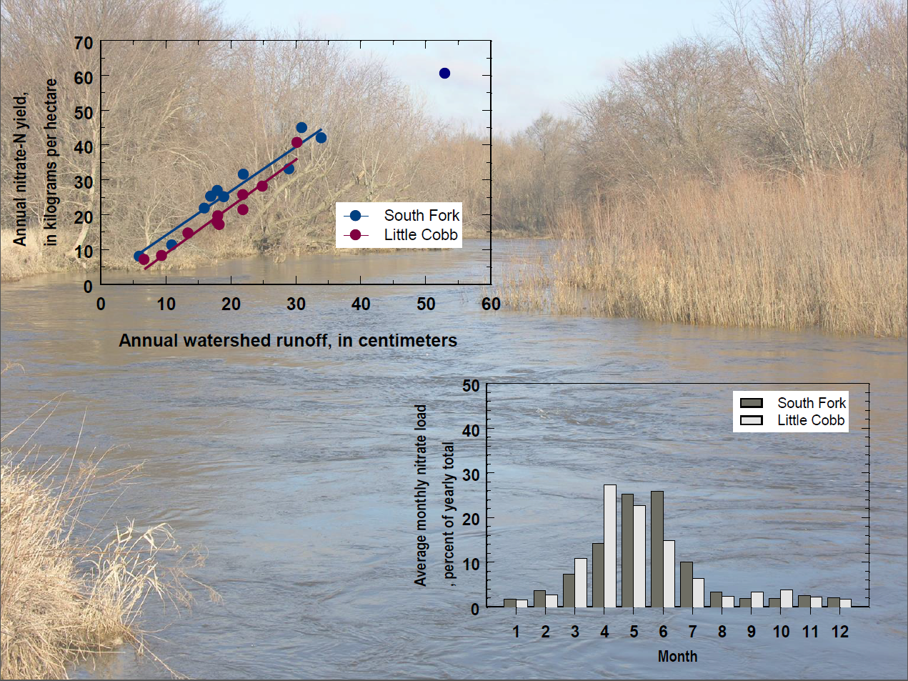
Paired Stream Study Report Released
The Little Cobb River in Minnesota and South Fork Iowa
River in Iowa are compared in a recent USGS publication.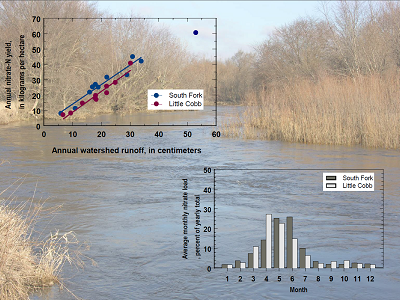 |
Two largely agricultural watersheds, the Little Cobb River in Minnesota and the South Fork Iowa River in Iowa, have been studied over an 11-year period. A new paper by Steve Kalkhoff and others examines nutrient transport in relation to nutrient inputs and precipitation. Despite similar agricultural systems in the two watersheds, the nitrate yield (amount of nitrate transported per acre) in relation to runoff was greater in the South Fork Iowa River watershed, which is the watershed with greater fertilizer use and greater numbers of hogs. About 65 percent of the nitrate and 50 percent of the total phosphorus were transported in the spring (April through June).
Full citation: Kalkhoff, S.J., Hubbard, L.E., Tomer, M.D., and James, D.E., 2016, Effect of variable annual precipitation and nutrient input on nitrogen and phosphorus transport from two Midwestern agricultural watersheds: Science of the Total Environment, v. 559, p. 53-62, http://dx.doi.org/10.1016/j.scitotenv.2016.03.127.
Contact: Steve Kalkhoff, sjkalkho@usgs.gov
Mercury in Rainfall Continues to Decline, but Some Areas in the West Show Recent Uptick
Precipitation collector for the Mercury
Deposition Network |
Mark Brigham, MN WSC, is a coauthor of a recent paper that examined trends in mercury in wet deposition, as well as gaseous mercury concentrations in the atmosphere across the United States and Canada. More than one-half of the sites with data records from 1997–2013 showed significant downward trends in mercury concentration in wet deposition, whereas no sites had significant positive trends. This longer-term decline is consistent with controls on mercury emissions in the United States and Canada. However, more recently (2008-2013), annual mercury deposition rates at many sites have leveled off, and even increased in some areas--particularly in the Rocky Mountains, Plains, and Upper Midwest. The observed shift to more positive or less negative trends in mercury wet deposition seen primarily in the Central-Western regions is consistent with the effects of rising mercury emissions from regions outside the United States and Canada and the influence of long-range transport. The work was led by Peter Weiss-Penzias of University of California-Santa Cruz, with funding from the Electric Power Research Institute, and included scientists from several additional collaborating institutions.
Full citation: Weiss-Penzias, P.S., Gay, D.A., Brigham, M.E., Parsons, M.T., Gustin, M.S., and ter Schure, A., 2016, Trends in mercury wet deposition and mercury air concentrations across the U.S. and Canada: Science of the Total Environment., http://dx.doi.org/10.1016/j.scitotenv.2016.01.061.
Contact: Mark Brigham, mbrigham@usgs.gov
Arsenic in Minnesota Groundwater
Mindy Erickson, speaking to the American
Institute of Professional Geologists.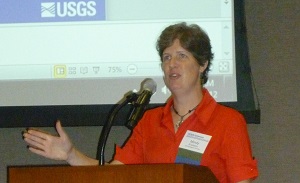 |
In April, Dr. Mindy Erickson presented an invited talk at the Minnesota section of the American Institute of Professional Geologists. The talk, "Arsenic in Minnesota groundwater—Occurrence and relation to hydrogeologic and geochemical factors," presented the purpose and preliminary results from ongoing research related to naturally occurring arsenic in groundwater. The study is being conducted in cooperation with the Minnesota Department of Health.
International Rainy-Lake of The Woods Watershed Forum
Algal bloom in Sullivan Bay, on Lake Kabetogama,
Voyageurs National Park, 2011.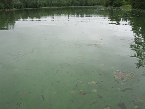 |
In March, USGS scientists participated in the International Rainy-Lake of the Woods Watershed Forum. Dr. Richard Kiesling and Dr. Erik Smith presented an invited keynote talk on the use of predictive models to assess lake ecosystem responses. The talk is based on cooperative research with the Minnesota Department of Natural Resources (Minnesota DNR) funded by the Environment and Natural Resources Trust Fund of Minnesota. Victoria Christensen and Erin Stelzer presented "Using molecular tools to understand and predict cyanobacterial harmful algal bloom toxicity in Kabetogama Lake, Voyageurs National Park, Minnesota," which summarized plans for a new study on cyanobacteria in Voyageurs National Park. Sarah Elliott presented "Assessing the influence of copper-nickel-bearing bedrock on baseline water quality in three northeastern Minnesota watersheds," which highlighted work being completed in collaboration with Natural Resources Research Institute and Minnesota DNR.
Government on Display Expo
USGS Scientists Aliesha Diekoff and James Fallon
participate in Government on Display at the
Mall of America.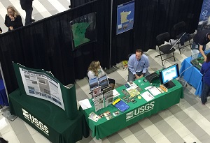 |
The MN WSC coordinated a USGS exhibit at the annual Government on Display Expo at the Mall of America on January 30. The display this year had a laptop and internet connection so visitors could view different USGS web sources, like EarthNow!, which is a great visual tool. The Minnesota Federal Executive Board hosts the event, which is open to the public. The USGS display was located adjacent to exhibits by the National Weather Service and the U.S. Army Corps of Engineers, with approximately 20 agencies participating.
News from the Water Mission Area of the USGS
Funds from the National Groundwater and Streamflow
Information Program were used to upgrade and flood
harden more than five streamgages in Minnesota in 2016,
including this one at the Cottonwood River near New Ulm.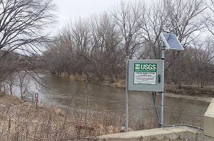 |
The new National Groundwater and Streamflow Information Program comprises two main parts: the Groundwater Network and the National Streamflow Network. The Groundwater Network includes the USGS monitoring networks funded through reimbursable work, the USGS Climate Response Network, and the collaborative National Groundwater Monitoring Network.
The National Streamflow Network includes two USGS Federal funding sources: the Federal Priority Streamgages (FPS, formerly National Streamflow Information Program or NSIP) and the Cooperative Matching Funds (CMF). The CMF and the Cooperator Funds (State, Regional, Tribal, Local, etc.) are jointly administered together as the CMF needs those partner agencies. The other partners in the National Streamflow Network include the U.S. Army Corps of Engineers, the single largest partner of the USGS. Other Federal Agencies, such as the Bureau of Reclamation and the National Park Service, also contribute funding to the network. Finally, other sources of funds include the Federal Energy Regulatory Commission, Cooperative Research and Development Agreements, and private industry.
In Minnesota, the Federal Priority Streamgage network funds approximately 25 percent of the streamgages operated by the USGS, including complete funding of 19 streamgages. The FPS is also used to support the network infrastructure of these priority streamgages. In 2016, more than $45,000 was used to upgrade or flood-harden streamgages at the St. Croix River at Stillwater (05341550), Yellow Medicine River near Granite Falls (05313500), Watonwan River near Garden City (05319500), Cottonwood River near New Ulm (05317000), and Minnesota River at Ortonville (05292000). In addition, a new streamgage for National Weather Service flood forecasting will be installed at the Minnesota River at New Ulm this summer.
Recent USGS Research on Coal-Tar Based Pavement Sealcoat Highlighted in New USGS Fact Sheet—Potential Concerns for Human Health and Aquatic Life
Sealcoat is the black, viscous liquid sprayed or painted on many asphalt parking lots, driveways, and playgrounds to protect the underlying asphalt and enhance its appearance. The coal-tar-based formulation, commonly used across the central and eastern parts of the United States, contains elevated levels of polycyclic aromatic hydrocarbons (PAHs) and related chemicals. Friction from vehicle tires abrades sealcoat into small particles that can be tracked indoors or washed down storm drains and into streams, potentially harming human and aquatic life. USGS research indicates that, for people who live adjacent to coal-tar-sealcoated pavement, ingestion of PAH-contaminated house dust and soil results in an elevated potential cancer risk, particularly for young children. Runoff from coal-tar-sealcoated pavement is acutely toxic to fathead minnows and water fleas, two species commonly used to assess toxicity to aquatic life, and exposure to even highly diluted runoff can damage DNA and impair DNA repair.
Citation: Mahler, B.J., Woodside, M.D., and VanMetre, P.C., 2016, Coal-tar-based pavement sealcoat—Potential concerns for human health and aquatic life: U.S. Geological Survey Fact Sheet 2016–3017, 6 p., http://dx.doi.org/10.3133/fs20163017.
For more information, see http://tx.usgs.gov/sealcoat.html.
Contact: Barbara Mahler, bjmahler@usgs.gov.
Nitrate at Historically High Levels in Some Midwest Streams in 2013-Highest Nitrate Concentrations found in Iowa, Minnesota, and Illinois
High-frequency nitrate sensor on the Mississippi River.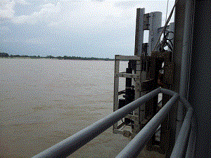 |
Drought periods followed by rainfall caused nitrate levels to increase to the highest ever measured in some Midwest streams during a 2013 study, according to a U.S. Geological Survey report published in the Journal of Environmental Quality. Nitrate, a form of nitrogen, is a common pollutant in U.S. streams and groundwater. Excessive concentrations in streams and lakes can adversely affect biological communities and spur algal growth, which can lead to harmful algal blooms and deplete oxygen in the water causing hypoxia, or "dead zones."
The USGS and the U.S. Environmental Protection Agency collaborated in 2013 to sample 100 small streams across parts of 11 States in the Midwest. The nitrate analysis included comparing 2013 findings to 20 years of nitrate results for more than 1,000 streams across the region.
"The highest nitrate concentrations in 2013 were in streams in Iowa, closely followed by southern Minnesota and central Illinois," said Peter Van Metre, a USGS hydrologist and the lead author of the study. "Drought conditions in 2012 allowed excess nitrogen to build up in the soils until spring rains in 2013 flushed the nitrate into streams, leading to unusually high levels."
Researchers also concluded that the most important source of the nitrate was application of nitrogen-rich fertilizer and manure, primarily for corn production.
Citation: Van Metre, P.C., Frey, J.W., Musgrove, M., Nakagaki, N., Qi, S., Mahler, B.J., Wieczorek, M.E., and Button, D.T., 2016, High nitrate concentrations in some Midwest United States streams in 2013 after the 2012 drought: Journal of Environmental Quality, http://dx.doi.org/10.2134/jeq2015.12.0591.
News release: https://www.usgs.gov/news/rainfall-following-drought-linked-historic-nitrate-levels-some-midwest-streams-2013.
Support for this work was provided by the USGS National Water Quality Assessment Project (NAWQA).
|